Tag Archives: Science

Two hours by car from Cancún’s beaches, the ancient Mayan city of CHICHÉN-ITZÁ in Mexico’s Yucatán jungle offers a view into a lost civilization’s temples, pyramids, and astronomical observatories.

FEATURE image: Chichén-Itzá serpent head sculptures guard a staircase. Author’s photograph.

By John P. Walsh

Serpent head at the base of El Castillo. Author’s photograph.

Cancún’s sandy spit of land at the northern tip of the Yucatán peninsula was uninhabited by the ancient Mayans. It was trodden by the conquistadores and used by pirates as a hide-out. Today, oozing like wet plaster into the Caribbean sea, the beaches are a new jet-age resort. I visited the Yucatán from Chicago for a few days in May 1988.

Though the tourist board in Cancún was telling of more resort development by the mid-1990s, it already boasted of 85 hotels and about 9,000 guest rooms during my trip.

After two days acclimating myself nicely to the Caribbean climate and working my way un poco with the Spanish language, I signed up with a local tour operator for a 12-hour bus tour. The destination was to one of the most famous sites on the Yucatán peninsula and the world: the ancient Mayan archeological site of Chichén-Itzá.

With its mysterious, virtually-intact looming pyramids and temples as well as startling tales of human sacrifice and one of the world’s most accurate cosmic calendar systems—all over 1,000 years old—I was excited to adventure out of the comfort of Cancún’s “Zona Hotelera” into the Yucatán jungle interior.

Setting out from Cancún into the Yucatán jungle

Iguana

The ancient Mayan cities and later Spanish colonial ones that sit on top of them are a stark contrast to the touristy jet-set beaches of Cancún.

An extensive jungle stretches across the Yucatán’s three states of Quintana Roo, Campeche, and Yucatán that are inhabited by human communities as well as wild animals such as jaguars. We frequently saw black-headed, blue-bodied birds called Yucatán jays. We saw iguanas on sun-washed rocks.

Yucatán jays.

I left the hotel and met the bus in Cancún town at 8:00 a.m. Francisco drove the air-conditioned 40-seater as Raúl toted a microphone and told the group about some of the things we were seeing along the way.

They took us out of Quintana Roo’s Cancún to Yucatán’s Chichén-Itzá about 125 miles away. On arrow-straight highway 180 we drove into small local communities along the two-lane road. We would reach Chichén-Itzá out of Valladolid, the Mayan/Spanish colonial city which is sometimes called the most colorful town in Mexico.

Chichén-Itzá’s famous complex of Mayan ruins dates from the Classic period of 600 CE to 1200 CE. Important archeological sites in the Yucatán still await reclamation from the jungle today –such as smaller Cobá in Quintana Roo. Guided tours are recommended for an extensive and remarkably safe visit into these interesting backwater places.

Highway 180: Route From Cancún to Valladolid

Yucatán’s South 180. Author’s photograph.

The bus climbed onto south highway 180 and followed it through villages such as Cocoyol, Catzin, Chemax, Xalaú, and others. Along the route there were thatched-roof dwellings which held patterned hammocks inside. Outside, dogs slinked around and small farm animals sometimes shared the road. The entire Yucatán peninsula is sparsley populated with only a fraction (about 4%) of Mexico’s total population. 

Francisco told us that the thatched-roof dwellings were durable. One such dwelling could last almost 20 years. The huts were made of sticks which we were told kept dwellers cool and comfortable year-round. Raúl said that the average year-round temperature on the peninsula was 93 degrees Fahrenheit. Starting in April, humidity levels rose and the temperature hovered over 100 degrees. Thatched hut dwellings were the predominant local housing we saw from highway 180.

Traditional Mayan homes. Author’s photograph.

With exceptions, the lifestyle of modern Mayans has not strayed from their ancestors’ of the last millennia. Traditional Mayan homes are oval-shaped huts made of sticks bound together to form walls. Palm fronds are laid upon the wood frame for a peaked roof. Inside there is a main room usually with a dirt floor. Hammocks create a sleeping area.

In Valladolid, a Spanish colonial town founded in 1543, there were larger stores. From the bus windows, we saw local women in the huipil, the traditional garment worn by indigenous women from central Mexico to Central America, doing their errands. They outnumbered men on the street who were mostly absent on this sunny and hot May morning in the middle of the week.

Larger Stores in Valladolid. Author’s photograph.
Author’s photograph.

Raúl said the men worked in Cancún during the week for about eight dollars a day, This wage was significantly higher than the $5 a day usually earned on the peninsula. The workers, Raúl said, are “smart” because when they are working, they live at the hotels where they eat, shower, and live rent-free. When they return home to the villages, they bring all of their earnings with them to their families. In most of these outlying towns it requires about $40 per week in income to meet living expenses, whereas workers in Cancún can earn nearly twice that amount.

Iglesia de San Servacio in Valladolid was built in 1545

The Iglesia de San Servacio is in the center of Valladolid on the south side of the main square. It was founded and built by Fr. Francisco Hernandez on March 24, 1545.

In 1705 part of the original church was demolished by order of the Benedictine bishop of Yucatán, Pedro Reyes de los Ríos de Lamadrid (1657-1714). The bishop ordered this partial demolition following the desecration of the sacred building during a political battle in July 1703 known as the “Crime of Mayors.”

San Servacio in Valladolid, Mexico. Author’s photograph.

July 1703: San Servicio desecrated in the “Crime of Mayors”

After Captain Hipólito de Osorno lost political favor in Valladolid he decided, together with his lawyer Pedro Gabriel de Covarrubias, to take refuge in the church of San Servacio.

But the political excitement of the time had reached an uncontrollable situation. In the pre-dawn hours of July 1703, a frenzied mob, led by Valladolid’s newly-elected mayors, Señors Avuso and Tovar, broke into the sacred enclosure.

The lawyer De Covarrubias was killed in the church after being driven through by a spear. His blood spilled on the altar and stained it. The captain was mortally wounded when the mob found him hidden behind the organ. The ruckus in no way benefitted the two new mayors. Both Señors Ayuso and Tovar were found guilty of murder and hanged.

Due to this murder in the cathedral the bishop had it rebuilt in 1706 as it is seen today. The altar’s position was moved to face north and west towards Rome. The church building is located on Valladolid’s main square named after Francisco Cantón Rosado (1833-1917), a conservative governor of Yucatán (1898-1902).

In early 18th Century Yucatán, a Benedictine Bishop and Franciscan Church

The church building’s main façade has a coat of arms carved on stone with arabesques, a royal crown, and a Franciscan cord. There are images of an eagle and a palm that were frequently used in the decoration of Franciscan churches in the Yucatán. Two square-shaped towers rise on either side of the central façade.

Downtown Valladolid. Author’s photograph.

Ancient Mayans are 1,000 years older than the oldest books of the Bible

The Mayan civilization is shrouded in the mists of history. Archeologists, anthropologists and historians have speculated that they originated in about in 2600 BCE in the middle of the Bronze Age (3300 BCE to 1300 BCE). The origins of the Mayans therefore predate the oldest books of the Bible by 1,000 years.

Mayan technical skill extended to complex calendar systems and hieroglyphic writing whose images are in evidence at Chichén-Itzá. Mayan artisans were skillful weavers and potters and artifacts have been found in vast quantities at the site. The ancient Mayans also cleared routes for trade. Their main source of fresh water was from cenotes (sink-holes) and they stored rainwater in reservoirs called chultun.

Mayan civilization was socially complex and technologically evolved

Mayan culture made remarkable advances in mathematics and astronomy. Mayans are known for their impressive urban planning, farming methods, and architectural achievements. All of these impressive achievements are to be seen at Chichén-Itzá in its pyramids, temples, ball courts, palaces, and astronomical observatories.

By 300 BCE Mayan society had evolved into a hierarchical social structure where kings and priests ruled. Stretching from Cancún through the Yucatán, Belize, and Guatemala to the coast of the Pacific Ocean, Mayan civilization was a highly structured society. It consisted of several independent states, each possessed of several classes—a ruling class, warrior class, and agricultural class. The society reached its apex in the Classic period from about 200 CE to 900 CE.

The stone monuments at Chichén-Itzá were built as a ceremonial center during the Classic period. As it continues to impress visitors today, it accomplished the same thing for ancient Mayans over 1,000 years ago.

Toltecs absorb Ancient Mayans in about 900 A.D.

The decline of ancient Mayan civilization started around 900 CE as they began to surrender their independence to the Toltecs who absorbed them. The Toltecs were another pre- Colonial Mesoamerican civilization located in central Mexico that reached its height between around 900 to almost 1200 CE. Though Chichén-Itzá as a ceremonial center would not die for another 250 years, the city became a vestige of itself whose remnants alone of a great civilization survived when conquered by the Spanish colonists in the 15th century.

Chichén-Itzá today

It was hot and humid when we arrived into Chichén-Itzá. Discovered by explorers as early as the 1830’s—and opened to the public in 1922—it was today an impressive and expansive series of ancient stone monuments on a grassy 1200-acre campus carved out of jungle. Do people live further into the jungle? Raúl said about one mile from the road there are small communities of two or three hundred people who live in farther from the main road.

The pyramids and temples of Chichén-Itzá are the Yucatán’s best known monuments. The Mayan city was absorbed by the Toltecs in 987 CE. According to legend, a man named Kukulcan—who is the same figure as Quetzalcoatl from the Toltec capital of Tula —arrived from the west “for the redemption of his people.” In Chichén-Itzá, Kukulcan built this magnificent city which combined the Puuc style of the Mayans and the motifs of the Toltecs, namely, the feathered serpent, warriors, eagles and jaguars.

Maya explorers include American Edward Thompson (1857-1935) and others

Starting in the midnineteenth century and again at the end of the century, there was a range of scientists and explorers associated with the discovery and excavation of the archeological site of Chichén-Itzá that is seen today.

As its great natural water well (or cenote) likely gave Chichén-Itzá its name, one major figure worth considering is the early American explorer Edward Thompson (1857-1935). For most of his adult life Edward Thompson lived and worked at Chichén-Itzá including famously dredging and diving into the sacred well in search of treasure and human remains for evidence of legends of human sacrifices.

A diplomat by profession and an amateur archeologist, Thompson had an indefatigable curiosity about the ancient Mayan ceremonial city and did important work here.

As a young scholar Thompson was inspired by the writings of American explorer and diplomat John Lloyd Stephens (1805-1852). Together with English artist Frederick Catherwood (1799-1845) they were pivotal figures in the rediscovery of Maya civilization in Central America.

Catherwood’s detailed drawings of the ruins of the Maya civilization explored by Stephens led to best-selling books published in the early 1840s such as Incidents of Travel in Central America, Chiapas and Yucatán and Incidents of Travel in Yucatán. These were illustrated works that introduced Europe and the United States to the civilization of the ancient Maya.

Portrait of John Lloyd Stephens, whose Incidents of Travel in Central America, Chiapas and Yucatán was published in 1854. Public Domain.
Lithograph of a maize god by Frederick Catherwood in Views of Ancient Monuments in Central America, Chiapas, and Yucatán published in 1844. Public Domain.

Stephens and Catherwood in turn had been inspired by earlier pioneers of scientists and explorers. Two figures who influenced them were Alexander von Humboldt (1769-1859) and Juan Galindo (1802–1840).

Portrait of Alexander von Humboldt by Joseph K. Stieler (1843). Charlottenhof. Public Domain.
Juan Galindo before 1839. From the book Ancient Maya Cities: The Hidden Wonders in the Forest. Public Domain.

Von Humboldt was a Prussian geographer, naturalist, and explorer whose work in botanical geography led to the development of the field of biogeography. Galindo was an Anglo-Irish military and administrative officer in the short-lived liberal Federal Republic of Central America (1823-1841) and who was actively engaged in Maya archeology.

In 1847 the Caste War of Yucatán broke out limiting access to the Yucatán’s unexcavated ruins. The Caste War restricted the borders of Yucatán and Quintana Roo to all but indigenous Maya for nearly 60 years, making travel to the area dangerous. When the United States appointed Edward Thompson archaeological consul to the Yucatán in 1895 he became one of the first to explore the land since the Caste War.

Edward Thompson, before 1920. Thompson famously dredged and dived the sacred well at Chichén-Itzá and brought up a fortune of gold and jade as well as human skeletons providing evidence for legends of ancient human sacrifice.

Edward Thompson arrived in the Yucatán at Mérida in 1895. He had purchased land in 1894 that included the unexcavated site of Chichén-Itzá. For the next 30 years Thompson dedicated his life to exploring the site.

Thompson dredges Sacred Well

In 1904 Thompson started to explore the bottom of the sacred well— the cenote sagrado. Thompson used divers (including himself) and dredges. Over six years he brought up a fortune in gold, copper and jade as well as a wealth of vases, obsidian glass knives and Maya incense called copal. Thompson did some of his explorations for major American museums such as The Field Museum in Chicago and the Peabody Museum at Harvard University, among others.

From his arrival, the sacred well attracted Thompson’s intense interest. In his 1932 book, People of the Serpent, Thompson stated he became intrigued with the murky waters of the great well as soon as he first saw it from the top of El Castillo.

Though most ancient Maya artifacts as well as its codice books with its written language were destroyed by the local Catholic Church authorities in the 16th century, Thompson read the colonial Spanish accounts of Mayan history.

Spanish Franciscan Fray Diego de Landa (1524-1579), colonial bishop of Yucatán. De Landa later regretted destroying the Maya civilization’s cultural treasures and wrote a history of the Mayas (Relación de las cosas de Yucatán, c. 1566) to make up for his thoughtless, wholesale destruction. Edward Thompson read the bishop’s account of the “cenote,” where Fray Diego detailed the pilgrimages of ancient Maya priests and farmers to the sacred well to “appease the gods.” These pilgrimages included throwing gold and ornaments into the waters. The bishop’s history also told of human sacrifices there as well. Public Domain.

To implement his plan to explore the cenote, Thompson returned to his hometown of Boston where he raised money, took diving lessons, and constructed a specialized diving mechanism. Thompson sent the dredging bucket, winch, tackles, steel cables, derrick and 30-foot boom to Chichén-Itzá.

The dredge buckets brought up ornaments and objects of daily life. Thompson’s and another diver’s plunges discovered more precious treasures, including human skeletons. These discoveries were controversial. The fact that this ancient site was being disturbed brought critics. Further, Thompson was neither a scientist nor academic but simply an enthusiastic amateur. He published his Maya civilization studies in Popular Science Magazine. But these critiques aside, Thompson’s field work virtually single-handedly put Chichén-Itzá on every world explorer’s own bucket list.

Edward Thompson dredged the sacred well at Chichén-Itzá between 1904 and 1910. Public Domain.
Cenote from the platform of El Castillo. This is the view Edward Thompson had when he first became fascinated with the sacred well in the late 1890’s. Photograph by author.

Thompson excavated graves at the Ossario (High Priest’s Temple), the mid-sized step-style pyramid within the Ossario Group complex of Mayan temples found just south of the Kukulkan pyramid series. Thompson’s discoveries offered an outcome not unlike the cenote. In the Ossario pyramid and its cave Thompson found more jade, pottery, human bones, and various other ancient Mayan artifacts.

How Chichén-Itzá’s pyramids were built

Close to Chichén-Itzá Thompson discovered pits with quarried veins of lime gravel that the Mayan’s used for mortar. Nearby he found stones of calcite (to hammer), flint (to pick) and smooth stones used to produce flat surfaces on walls. Ancient Mayan craftsmen had no metal tools, but these stone implements helped scientists to reconstruct how the monumental buildings could be constructed. Thompson also uncovered shards of nephrite (a type of jade) as well as the so-called Mayan “date” stone, known later as the Tablet of the Initial Series. This stone let iconographers decipher the dates of Chichén-Itzá’s Classic period.

In 1926 Thompson’s land was seized by authorities of Mexico’s new nationalist government and Thompson was charged with removing artifacts illegally. It was only in 1944, almost a decade after Thompson’s death, that the Mexican Supreme Court ruled in the North American explorer’s favor.

Major sites at Chichén-Itzá

Visitors climb El Castillo’s steps to the top in May 1988. A visit to the pyramid (Temple of Kukulkan), is a highlight at Chichén-Itzá. Photograph by author.

It is frankly thrilling to see the pre-Columbian Mesoamerican step pyramid. At nearly 80 feet tall, the pyramid dominates the center of the archaeological site of Chichén-Itzá. It was built between 700 and 1100 A.D.

Chac-Mool statue on top of the Temple of the Warriors at the ancient Mayan archeological site of Chichén-Itzá on the Yucatán peninsula. The impressive sculpture was used in ancient times as an altar for sacrifices. Author’s Photograph.
Chichén-Itzá relief carving depicting a Mayan warrior in elaborate headdress and jewelry. Warriors were one of the major classes in Mayan society in the Classic period. Author’s photograph.

El Castillo served as a temple to the god Kukulkan. Each side of the pyramid has 91 steps for a total of 364 steps. With the platform at the top, it equals the 365 days of the year. There are 52 smooth stone panels on each side of the pyramid which coordinates with the ancient Mayan calendar’s 52-year cycle. The nine terraces on each side of the pyramid represent the 18-month solar calendar.

Twice during Spring Equinox (March 21) at sunrise and sunset, the sunlight is observed to move down stair by stair from the top stair of the northern stairway until it touches the famous serpent head stone carving at the base of the pyramid. In a marvel of nature, sunlight and shadow work to form a “serpent” that appears to descend into the earth. The cosmological phenomenon was an important fertility symbol for the Mayans whose society was agricultural. It signaled that the golden sun had entered the earth in the form of a serpent and that it was time to plant corn.

Unexcavated El Castillo in 1882 in a photograph by Teobert Maler
El Castillo dominates the Great North Platform Series. Known as the Kukulkan Pyramid and the Temple of Kukulkan, the 8-story 1,500-year-old stone structure is a masterpiece of ancient Mayan Cosmovision. Author at Chichén-Itzá in May 1988. Author’s collection.
Snakehead sculpture at Chichén-Itzá in Mexico. There are smaller pyramids inside the Chichén-Itzá ruins with “snakehead” statues scattered around. Author’s photograph.
Walking towards the Nunnery complex with the stone steps of its north side in the distance. Author’s collection.
El Palacio in the complex of buildings called the Nunnery. Edward Thompson used these buildings as his headquarters during his first explorations of Chichén-Itzá. Author’s photograph.
This 1892 photograph of El Palacio (Templo de tres Cuerpos) of the building complex called the Nunnery at Chichén-Itzá gives record to one of Teobert Maler’s many expeditions. Public Domain.

Teobert Maler (1842–1917) was a pioneer of ancient Maya research. Maler’s expeditions to over 150 ruins in the Yucatán began secretly in the 1870s.

Several ruins Maler described and photographed had been discovered by him, and his photographs of its architecture and inscriptions aided further research in ancient Maya civilization.

Many sites Maler photographed were not visited by scientists until decades later. As the ruins were often further damaged by climate events or human impact—Maler’s photographs remain some of the best record of Maya ruins.

Because of Maler’s work at Chichén-Itzá and elsewhere, the German explorer is regarded as one of the most important research photographers of the 19th century.

Buildings of the Nunnery (Las Monjas) include La Iglesia (partial view, left). At Chichén-Itzá, Mayan-temple structures in the Puuc style. These buildings at Chichén-Itzá shared similar designs with the ruins at Kabah and Uxmal about 100 miles to the southwest of Chichén-Itzá. Author’s photograph.
In the day’s heat and humidity, the profligate flora delights the visitor’s senses at Chichén-Itzá. On the site’s 1200 acres, the blooms of jungle growth offer a feast of fragrances, colors and living forms. From the Temple of Warriors, the visitor can see nestled beyond a field of red flowers the Grupo de las Mil Columnas (“The Forest of 1,000 Columns”). These stone columns may once have had a thatched ceiling to enclose an expansive space. Author’s photograph.
In the landscape of Chichén-Itzá there are a variety of mammals, hundreds of species of birds and many reptiles. On the Yucatán peninsula there are almost 150 varieties of snakes, many of which, including at the archeological site, are highly venomous. A photograph of the jungle from the air in May 1988.
Coral Snake Closeup” by MyFWC Florida Fish and Wildlife is marked with CC BY-ND 2.0.
A visitor climbs atop the Nunnery, the Mayan temple complex built in the Puuc style during the Classic period of 600-1200 CE at Chichén-Itzá. Author’s photograph.
The El Caracol observatory temple at Chichén-Itzá. We visited the dark recesses of El Caracol’s central circular tower. The Mayas built the observatory over an extended period of time to coincide its construction with their increasing knowledge of day-time and night-time skies. The Mayas’ objective in building and using the observatory was to acquire more exact measurements of cosmic bodies. Author’s photograph.
The “Venus” staircase of the observatory at Chichén-Itzá. The highly sophisticated Maya calendar system was based on their study of the movements of the sun, moon, and planets, particularly Venus’s orbit. The position of El Caracol’s front staircase aligns with Venus’s most northern position while the building‘s corners are affixed to the sun’s position at sunrise of summer solstice (June 21) and sunset of winter solstice (December 21). Author’s photograph.
The Observatory temple at Chichén-Itzá in a photograph by Teobert Maler. When explorers first viewed the ruin in the late 19th century, it was buried in centuries of natural debris. Public Domain.
Maya Calendar System. Ancient Maya time-keepers designed highly accurate methods to measure time that interwove calendars as space/time cycles. Mayan calendars formed an understanding of the interrelationships of cosmic bodies—the moon orbiting the Earth; the Earth orbiting the sun; and the sun as it travels in the galaxy. Author’s photograph.
The Great Ball Court at Chichén-Itzá from El Castillo. Almost two football fields in length (181 yards), it is enclosed by 13-foot high stone walls and is the largest ball court in ancient Mesoamerica. Sports arenas like this were a staple in the sacred complexes of ancient Mayan cities. Some archeological anthropologists believe the nature of play in the ball courts had a purely sporting purpose, though the games may have had high-stakes cosmological and mythological dimensions.
Grand Ballcourt—field of play. Author’s photograph.
Temple of Warriors. The Chac-Mool sits atop the platform of this temple dedicated to the Mayan warrior class. Author’s photograph.

OTHER PHOTOGRAPH CREDITS:
YUCHATAN JAYS – Licensed under the Creative Commons Attribution 2.0 Generic  license. Tony Hisgett – originally posted to Flickr as Yucatan Jays – immature
IGUANA – CC BY-SA 2.0 view terms.

History and reportage of the amazing natural event of May 18, 1980: the eruption of MOUNT ST. HELENS, Washington.

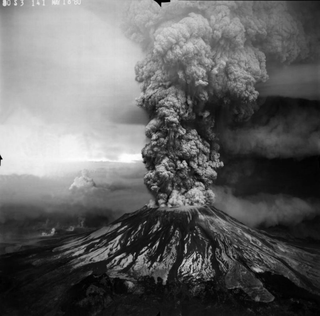
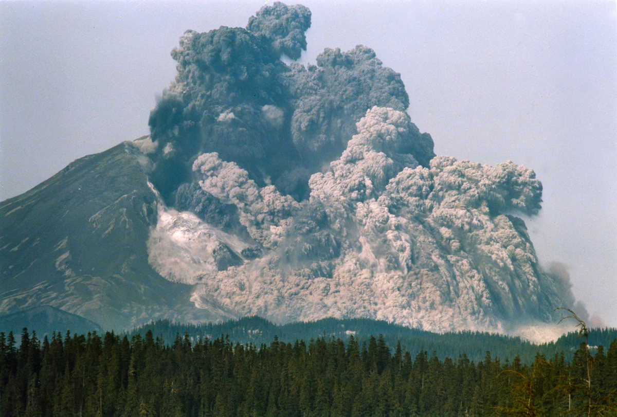
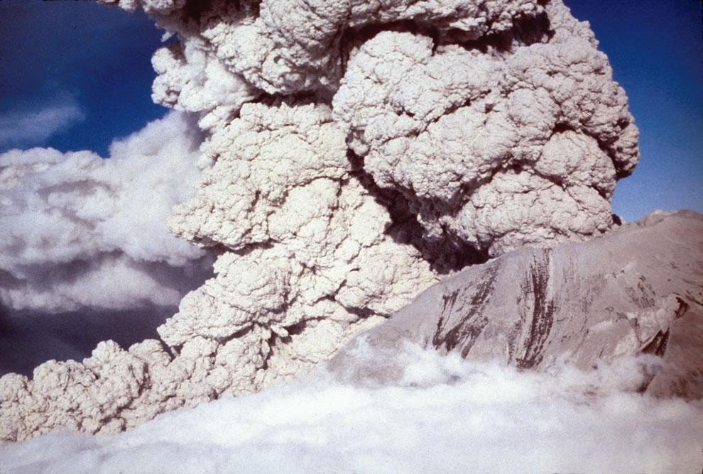
FEATURE image: Phreatic or steam-blast eruption from the summit crater of Mount St. Helens on April 6, 1980. USGS/Public domain.

By John P. Walsh, May 18, 2016.

“Nobody lies about her lodestone any more. She burned and destroyed the whole park! Killed people too – what a pity! Only scientists are out there now. What’s there to see, dear? Isn’t it all in ruins?”

This is what the lady innkeeper told me in Portland, Oregon, before I set out in the car one early morning in July 1991 to visit the crater.

“It’s a pity she blew. It was such a pretty mountain before. WAS, I say. The kids loved camping at its base. It was so easy for them to get in and out. Then she blew and changed everything.”

I waved my good-byes and started the two-hour drive.

1980-Mt-St-Helens-BEFORE-eruption USFS Photo #15 taken before 18 May 1980 by Jim Nieland,
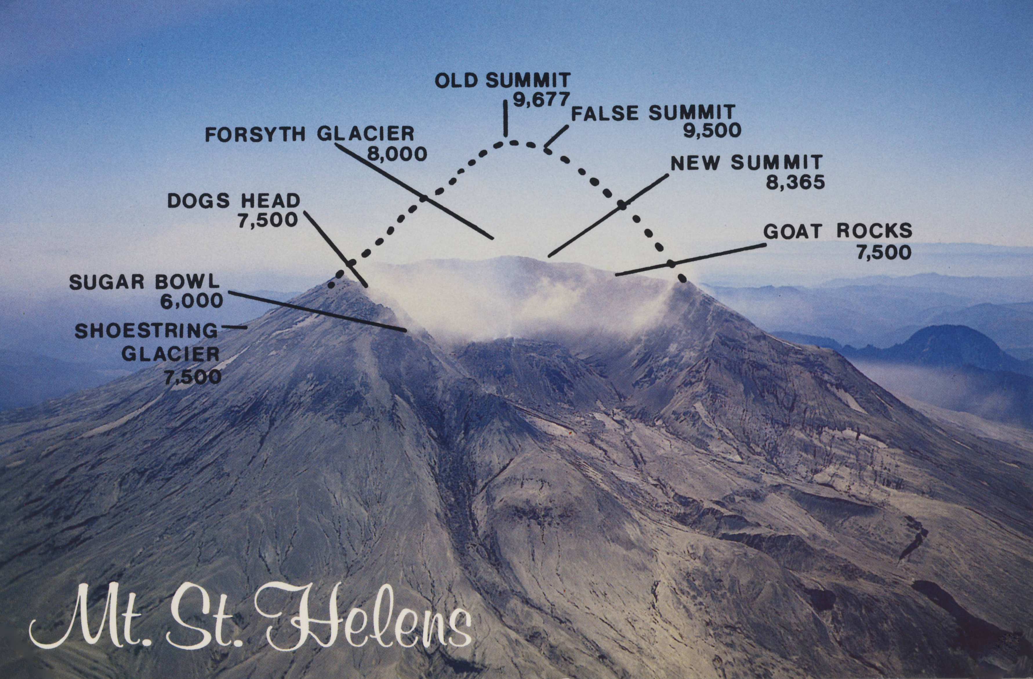
As seen from Spirit Lake, Mount St. Helens in 1980 BEFORE the eruption on May 18, 1980. United States Forest Service (USFS) photo by Jim Nieland. USGS/Public domain.
7_-Mount-St_-Helens-Aftermath-w-Drawing
Earthquakes, avalanches and a ten-minute eruption on May 18, 1980 toppled nearly 4,000 feet from the mountain summit. Author’s collection. Fair use.
April-1980-a-bulge-develops-on-the-north-side-of-Mount-St_-Helens-as-magma-pushed-up-within-the-peak-pushed 450 feet bby may 18 Photo #20 by Peter Lipman
In April 1980 a bulge developed on the north side of Mt. St. Helens as magma pushed up inside it. View from the northeast. Photo by Peter Lipman. USGS/Public domain.
Phreatic or steam-blast eruption from the summit crater of Mount St. Helens on April 6, 1980. Aerial view to the southwest. The ash-laden cloud surrounds and obscures a finger-like ash column with an upper white cloud formed by atmospheric condensation of water vapor. USGS/Public domain.

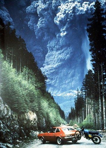
At 8:32 a.m. on Sunday, May 18, 1980, an earthquake followed by a landslide and near simultaneous volcanic blast changed forever – and in less than 10 minutes – a Cascades landscape of 230 square miles. Months before the unexpected blast, volcano watchers had camped near the mountain, including scientists and photographers, who were interested to gauge its recent unusual seismic and geological activity and capture what the mountain may do. Local property owners pressured authorities to be let back into their homes during this uncertain and, as it turned out, critically dangerous waiting period. Especially good weather brought out an extra contingent of weekend campers, backpackers and curiosity seekers to the mountain, many from Portland only 70 miles away.

Eruption Of Mt. St. Helens From Portland
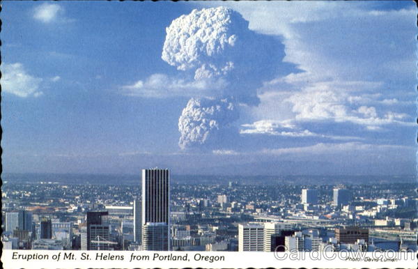
Eruption of Mt. St. Helens From Portland, ending 123 years of dormancy. This is the distance from which I traveled from the B&B to the National Volcanic Monument in July 1991 which is over 100 miles away. Fair Use.

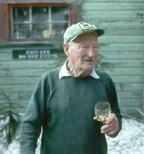
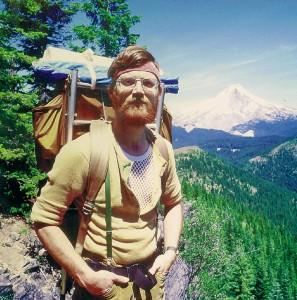
Everybody I talked to during my 1991 visit remembered 83-year-old Harry Randall Truman who lived by the mountain for over half his life and refused to leave in the days and weeks before the May 18, 1980 eruption. Not sure whether the mountain would blow or not, Truman, who served in the U.S. military in Europe in World War One, resigned himself to the mountain’s fiery whims. When the 1000-story high burbling volcano finally did blow, the avalanche and blast buried Mr.Truman, as it did Spirit Lake, in 350,000 acre-feet of fire and ash  debris. Mr. Truman’s body was never recovered nor did he represent the only loss of human life in the eruption. 

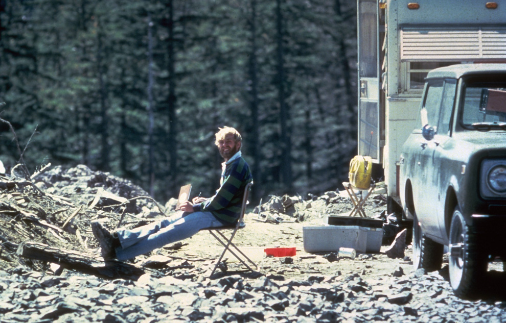
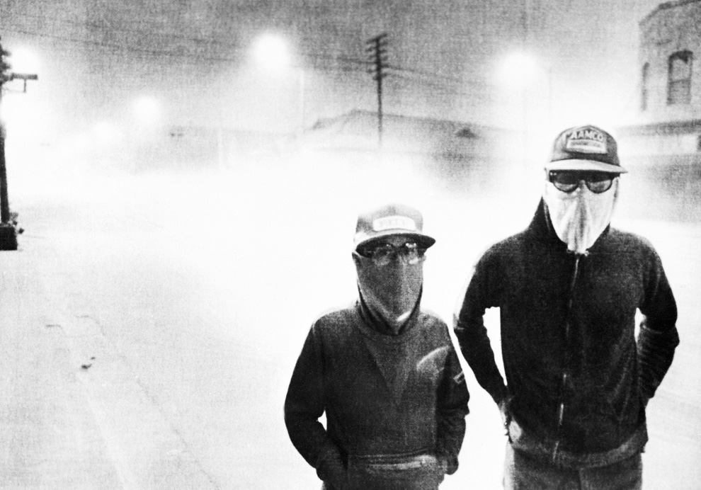
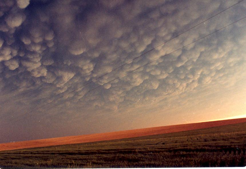
Harry Randall Truman (1896-1980), who lived by Mount St. Helens for 54 years, died in the blast when he refused to evacuate. Fair Use.
Harry Randall Truman lived less thana mile from the 1000-story Mount St. Helenswhen it erupted on May 18, 1980. Fair Use.
Reid Blackburn, 27, a photographer at The Columbian newspaper in Vancouver, Washington, was killed in the 1980 eruption of Mount St. Helens. Blackburn got caught in the blast at Coldwater Camp. While his car and body were recovered four days later, his camera only resurfaced after a week.
In this May 17, 1980 photo, 30-year old vulcanologist David Johnston is shown in the evening at his camp near what is now known as Johnston Ridge near Mount St. Helens.
The day before the blast – in this May 17, 1980 photo – 30-year-old volcanologist David Johnston is shown in the evening at his camp near what is now known as Johnston Ridge near Mount St. Helens. A principal scientist on the monitoring team, Johnston perished while manning an observation post 6 miles away on the morning of May 18, 1980. Johnston was the first to report the eruption, transmitting “Vancouver! Vancouver! This is it!” before he was swept away by the lateral blast. Johnston’s remains were never found, but state highway workers discovered remnants of his USGS trailer in 1993. Photo by Harry Glicken on May 17, 1980 at 19:00, 13 1/2 hours before the 1980 eruption. USGS/Public domain.
On Sunday, May 18, 1980 at 8:32 a.m., the bulging north flank of Mount St. Helens slid away in a massive landslide — the largest in recorded history. Seconds later, the uncorked volcano exploded and blasted rocks northward across forest ridges and valleys, destroying everything in its path within minutes. USGS/Public domain.
camper containing two victims of the Mount St. Helens eruption sits amidst the gray landscape about 8 miles from the mountain may 20 1980
This camper contains two victims of the Mount St. Helens eruption in a gray landscape about eight miles from the mountain, May 20, 1980. USGS/Public domain.
View downstream of the North Fork Toutle River valley choked by a debris avalanche deposit from the May 18, 1980 eruption of Mount St. Helens. USGS/Public domain.
streets of Yakima, Washington may 18
Streets of Yakima, Washington, May 18, 1980. Debris clouds moved east over the state of Washington and then the rest of the Continental United States and parts of Canada for weeks. Fair use.
Taken from a rest area near Lewiston, Idaho, on May 18, 1980, Mammatus clouds caused by volcanic ash over the Palouse of southeastern Washington, north central Idaho and northeast Oregon. Photograph by Betty Ehr. Fair use.
Mount St. Helens’ eruption May 18, 1980. The image is in the public domain in the United States because it only contains materials that originally came from the United States Geological Survey (USGS). See – https://www.usgs.gov/volcanoes/mount-st.-helens
Sixth in a series of photographs by Gary Rosenquist. (see- https://pubs.usgs.gov/gip/msh/catastrophic.html – retrieved June 24, 2021.)
Author entering the “Restricted Zone” of Mount St. Helens National Volcanic Monument in July 1991. About eight miles away, the collapsed north face of the mountain looms in the distance. Only a few months before the authorities had re-opened Mount St. Helens for the first time since the blast. It was named a National Volcanic Monument and deemed safe again for visitors. Mount St. Helens was partially destroyed by a series of earthquakes followed by the largest debris avalanche in history and a blast and pyroclastic flow that flattened everything in its path over 230 square miles. Author’s collection.

Only a few months before my July 1991 visit the authorities had re-opened Mount St. Helens for the first time in more than a decade. It was named a National Volcanic Monument and deemed safe again for visitors. After Bear Meadow I followed the prolonged twisting road to past Ghost Lake, Meta Lake and Norway Pass until I reached Independence Pass. From its overlook I saw  for the first time the ashen slough that had been Spirit Lake. For years prior to May 1980 several camps inhabited the shore around the lake’s perimeter. There had also been various lodges around the oblong-shaped lake including the one Mr. Truman lived in. On May 18, 1980 Spirit Lake met the full impact of the volcano’s lateral blast. The sheer force of the blast lifted the lake out of its bed and propelled it about 85 stories into the air to splash onto adjacent mountain slopes. Despite the weeks of warnings about a potential eruption of Mount St. Helens, the sole film records of the actual event are in photographs.

The long and winding road into the Mount St. Helens National Volcanic Monument travels towards Spirit lake and the volcanic rim. Author’s photograph, July 1991.

At 8:32 a.m. on May 18, 1980 a 5.2-magnitude earthquake triggered the bulging north slope of Mount St. Helens to slice and fall away into the biggest debris avalanche in recorded history. This landslide was rapidly succeeded by the powerful lateral blast that sent scorching hot ash and rock hurtling out of the mountain at approximately 300 miles per hour, toppling and incinerating everything in its northward path. Fifteen miles away from the mountain temperatures reached Fahrenheit 572 degrees.

Spirit-Lake-Pumice-Plain-and-phreatic-explosions-soon-after-the-May-18-1980-eruption-of-Mount-St_-Helens
Spirit Lake a few days after the eruption on May 18, 1980. USGS/Public domain.

While in 2016 plant and animal life continue to recover and augment as it has for decades now,  my boots in 1991 crunched into a gray, dusty moon-like surface. From Spirit Lake to Windy Ridge I was confronted by trees flattened like toothpicks as far as the eye could see, and a cauldron emitting wispy white smoke. The base of the mountain is four miles wide. The journey had taken me from civilization and delightful wilderness into mile upon mile of  badlands. My bodily presence was miniature in an immense, silent, and deserted landscape, the scene only a decade earlier of the most powerful natural event in the Continental United States in over one thousand years. While I heard some people talk about this volcanic eruption as comparable in its destructive power to that of a detonated atom bomb, I know that sort of comparison is ludicrous. For all its destructive force, this is not a disaster as it contains, if one requires patience to believe it,  a natural benignity – or what scientists  call a natural disturbance on a grand scale which allows mankind to study the natural cycle of death and life in a landscape. An atom bomb provides none of that -it only bestows extinction and contamination.

“The standing dead” by Rudimentary is licensed under CC BY-NC-ND 2.0 
msn 3 001 FIXED
A gray, dusty moon-like surface with trees flattened like toothpicks as far as the eye could see. At Mount St. Helens National Volcanic Monument, Author’s photograph, July 1991.

Ash and gas, accompanied by lightning, ascended 15 miles into the air at the speed of a mile a minute. In a blast that killed 57 people – many of whom were there to study and record its possible eventuality – it also decimated approximately 7,000 large animals and 12 million salmon. No trees of dense forest were left standing within 6 miles of the summit. Rescue operations continued for days with varied success.

Eruption of Mt St Helens May 18, 1980, Gifford Pinchot National Forest” by Forest Service Pacific Northwest Region is marked with CC PDM 1.0.
Army National Guard helicopter pilot Harold Kolb rescues two men and their sons
Army National Guard helicopter pilot Harold Kolb rescues two men and their sons from the eruption of May 18, 1980. USGS/Public domain.
horse rescuers gave up their efforts as they fled for their lives as flood waters from the Toutle Rive
Army National Guard helicopter pilot Harold Kolb rescues two men and their sons from the eruption of May 18, 1980. USGS/Public domain.
mudflow deposit covers Washington State Highway 504 near the town of Toutle, northwest of Mount St. Helens, to a depth of 2m (6 ft). USGSR.L. Schuster) #
Mudflow deposits cover State Highway 504 near of Toutle, to a depth of over six feet. Photo by USGS R.L. Schuster/Public Domain.
This aerial view shown May 23, 1980 from a search and rescue helicopter
This aerial view shown May 23, 1980 from a search and rescue helicopter. USGS/Public domain.
30210599_008_large
USGS/Public domain.
SGS Photograph taken on May 18, 1980, by Austin Post/Public Domain.
Tim_Florin_washed_road_t860
Encountering a washed-out road to the Mount St. Helens Visitor Center in late summer 1980.
in Moscow, Idaho more than 350 miles away (AP Photo Moscow-Pullman Daily News
Debris ash in Moscow, Idaho, over 350 miles away from the blast on May 18, 1980.
After the May 18, 1980 eruption, five more explosive eruptions took place at Mount St. Helens in 1980 including this spectacular one of July 22, 1980. Photo by Mike Doukas.
July-1980-Aerial-view-pryoclastic-flow-emerging-from-Mount-St_-Helens-craterUSGS Photo #22 taken at 701 p.m., on July 22, 1980, by Harry Glicken
July 1980 aerial view of pyroclastic flow from Mt. St. Helens. USGS Photo July 22, 1980, by Harry Glicken. USGS/Public domain.
Pyroclastic flow during August 7, 1980, Mount St. Helens eruption. The view is from Johnston Ridge, located 8 km (5 mi) north of Mount St. Helens. Photo: Peter Lipman. Public Domain.
a helicopter stirs up ash while trying to land in the devastated area on August 22nd, 1980. USGSLyn Topinka
A helicopter stirs up ash while trying to land in the devastated area on August 22, 1980. Photo by Lyn Topinka United States Geological Service. USGS/Public domain.
Fireweed with Spirit Lake n September 4, 1984
September 1984: Fireweed on the slopes of Spirit Lake four years after the eruption. Public Domain.
MOUNT ST HELENS
An eruption from Mount St. Helens on March 8, 2005. In 2016 the volcano is showing increased signs of significant seismic activity. AP Photo/USGS Matt Logan. USGS/Public domain.
65472-050-83D9BBC4
In 2016 in nature it is survival of the fittest – while woody plants are beginning to appear with the promise of a forest, the boll weevil is eating the wood. Photo credit: Michael Hynes.
lightning-over-mount-st-helens1
Mount st Helens May 18, 1980
This photo of an erupting Mount St. Helens has been published and viewed widely on television over the years since the eruption. Photo credit: Richard “Dick” Lasher.
Albert Bierstadt (1830-1902), Mount St. Helens, Columbia River, Oregon, oil on canvas mounted on panel, 18 x 32 1/4 inches (45.72 x 81.92 cm), Public collection.
Scenes of the eruption and its aftermath set to music from “Mount St Helens,” a symphony in three movements by Alan Hovhaness (1911-2001), Hovhaness completed the commissioned symphony in January 1982 and it premiered in March 1982, Hovhaness who lived in Seattle at the time, wrote for his symphony: “When Mount St. Helens erupted on the morning of May 18, 1980, the sonic boom struck our south windows. Ashes did not come here at that time but covered land to the east all across the State of Washington into Montana. Ashes continued to travel all around the world, landing lightly on our house a week later, after their journey all around our planet.”
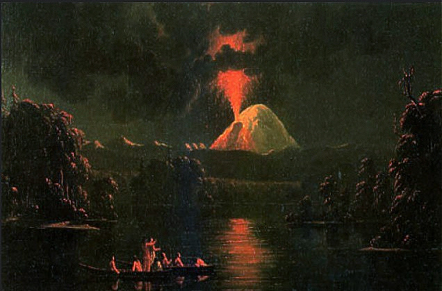
The volcano was particularly restless in the mid19th century, when it was notably active off and on for a 26-year span from 1831 to 1857. Canadian artist Paul Kane (1810–1871) painted Mount St Helens Erupting At Night in 1847 (Royal Ontario Museum, Toronto). Though considered once dormant, the volcano has been continually active in degrees over the centuries as this nineteenth century painting attests, and remains so today after the major 1980 blast. Public Domain.
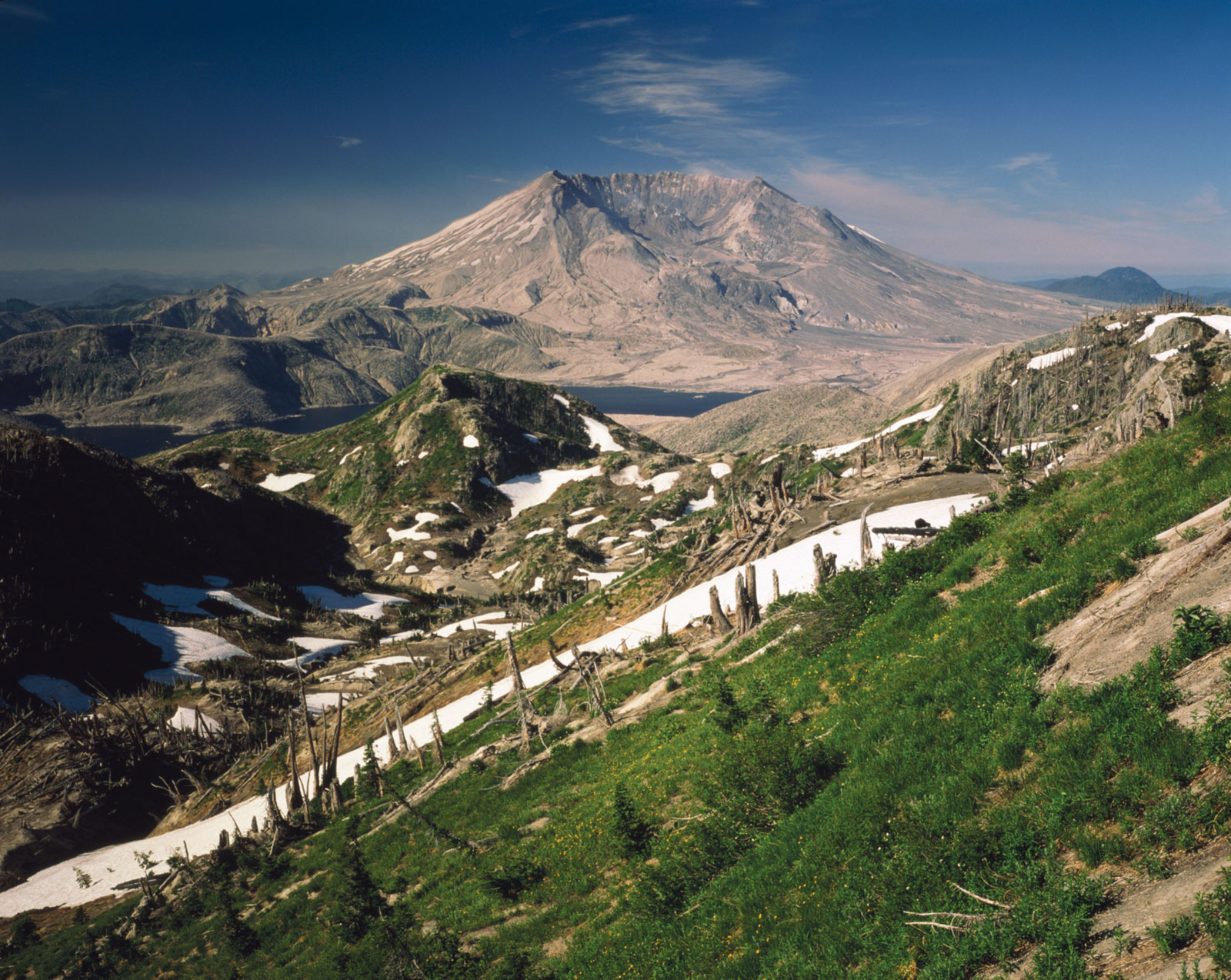
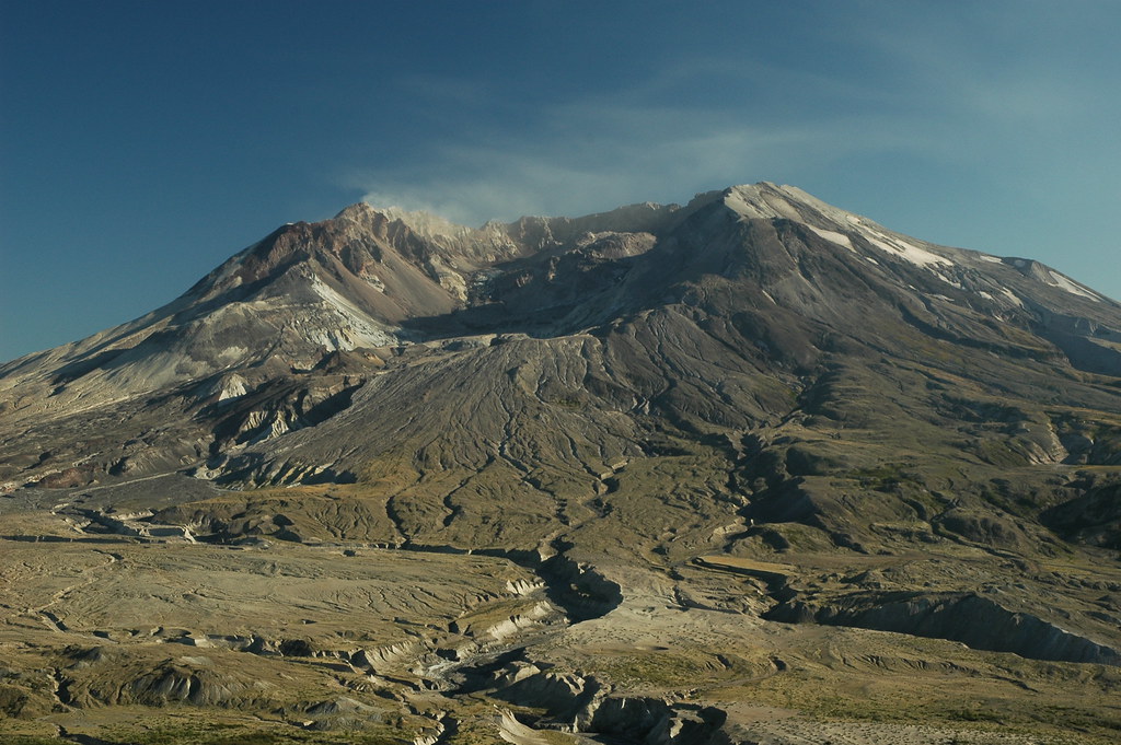
Mount Saint Helens today. The powerful lateral blast in May 1980 sent scorching hot ash and rock hurtling out of the mountain at approximately 300 miles per hour and resulted in toppling about 40% of the mountain’s height.Mount Saint Helens” by jimculp@live.com is licensed under CC BY-NC-ND 2.0.