Category Archives: Travel

BELOVED HOMETOWN OF PRESIDENT RONALD REAGAN (1911-2004): DIXON, ILLINOIS.

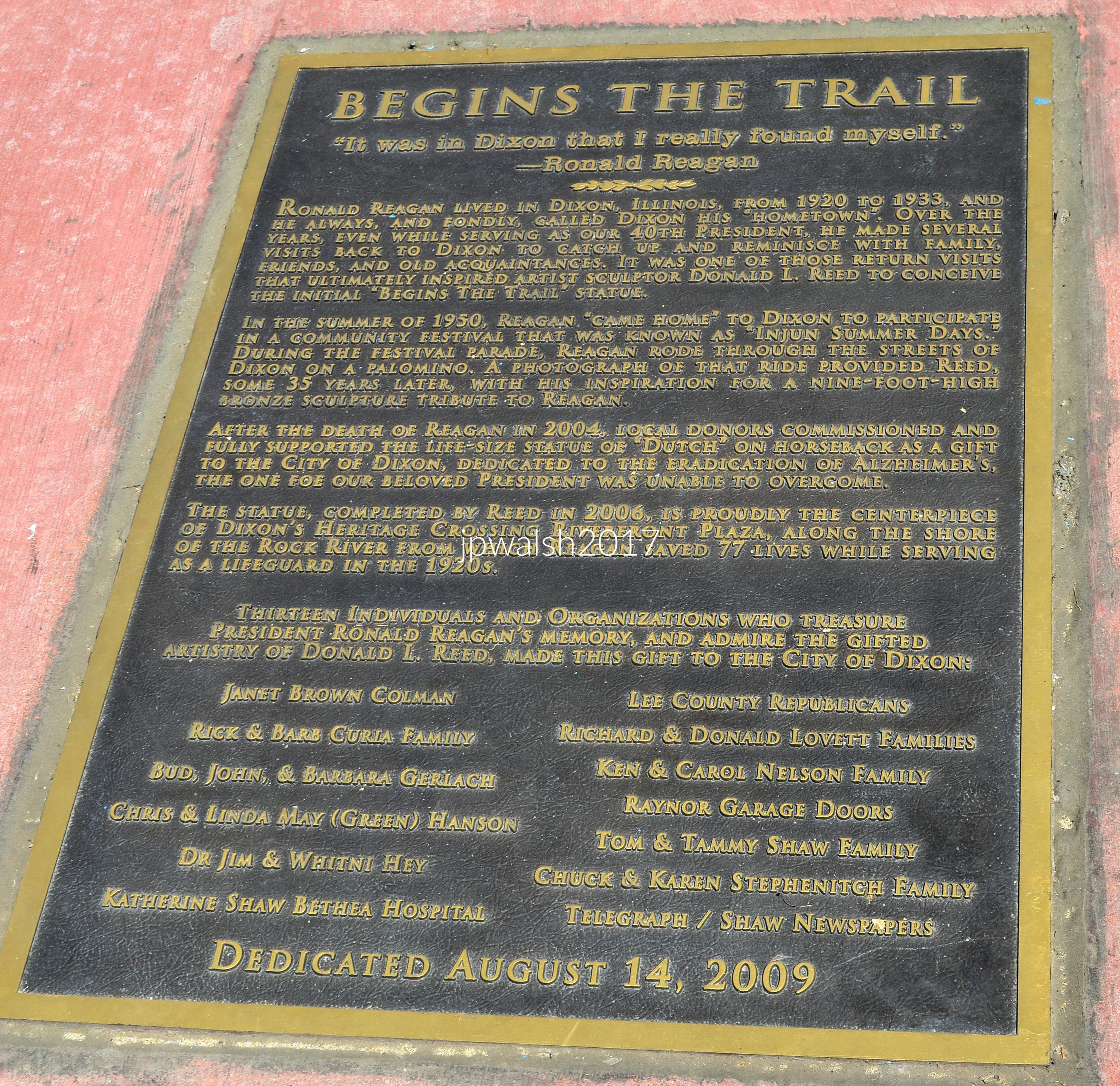
Feature Image: June 2017. 4.37mb DSC_0785. The statue of Ronald Reagan by American sculptor Donald L. Reed in DIxon, Illinois, was dedicated on August 14, 2009. It is based on a photograph of Reagan when he visited Dixon in 1950 and rode a horse through its streets in a parade. The statue itself is nine feet high on its pedestal and called Begins the Trail. It is the first of a series that includes a life-sized statue for the Reagan Foundation at the Ronald Reagan Presidential Library in Simi Valley, California, called Along the Trail. These artworks capture Reagan’s rugged amiable nature and his natural ability throughout life when riding. see – https://www.cowboysindians.com/2016/02/ronald-reagan-rides-again/ – retrieved April 13, 2025.

All text and photographs (except where noted) by John P. Walsh.

June 2017. 4.76mb DSC_0797.

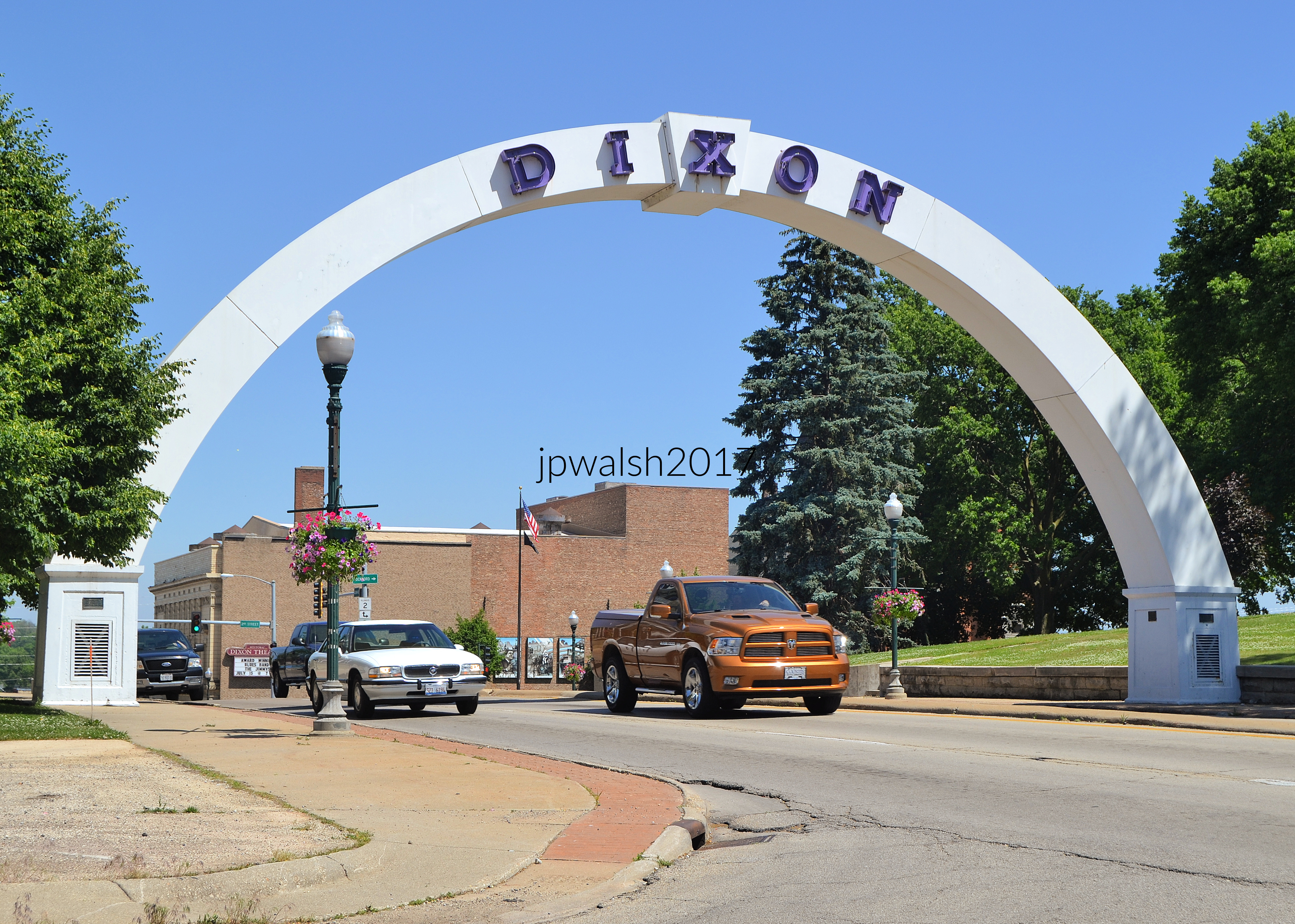
Considered the heart of Dixon, the memorial arch has been a landmark since the 1920s. The original arch, built in 1919, was made of beaver board and wood. It was built to celebrate the return of Dixon’s soldiers after World War One. In 1949, a new arch was constructed of wood. It was replaced in 1966 when Galena Avenue was widened. In 1985 the arch was replaced with this fiberglass one with the letters from the 1966 arch. In 2024 it went through a major restoration.
See – https://www.wifr.com/2024/06/04/dixons-iconic-memorial-arch-facing-repairs/ – retrieved February 28, 2025.

June 2017. 5.41mb DSC_0822.

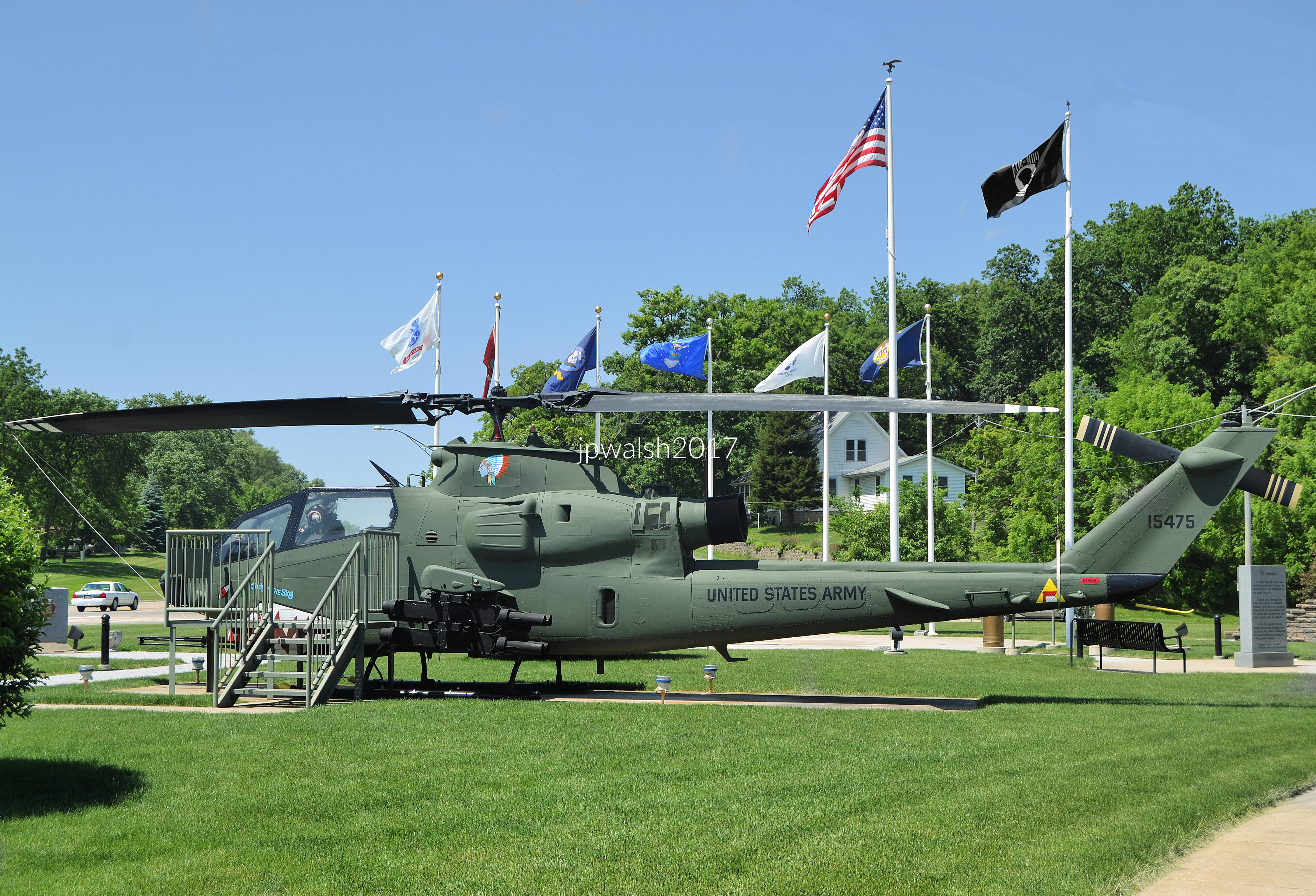
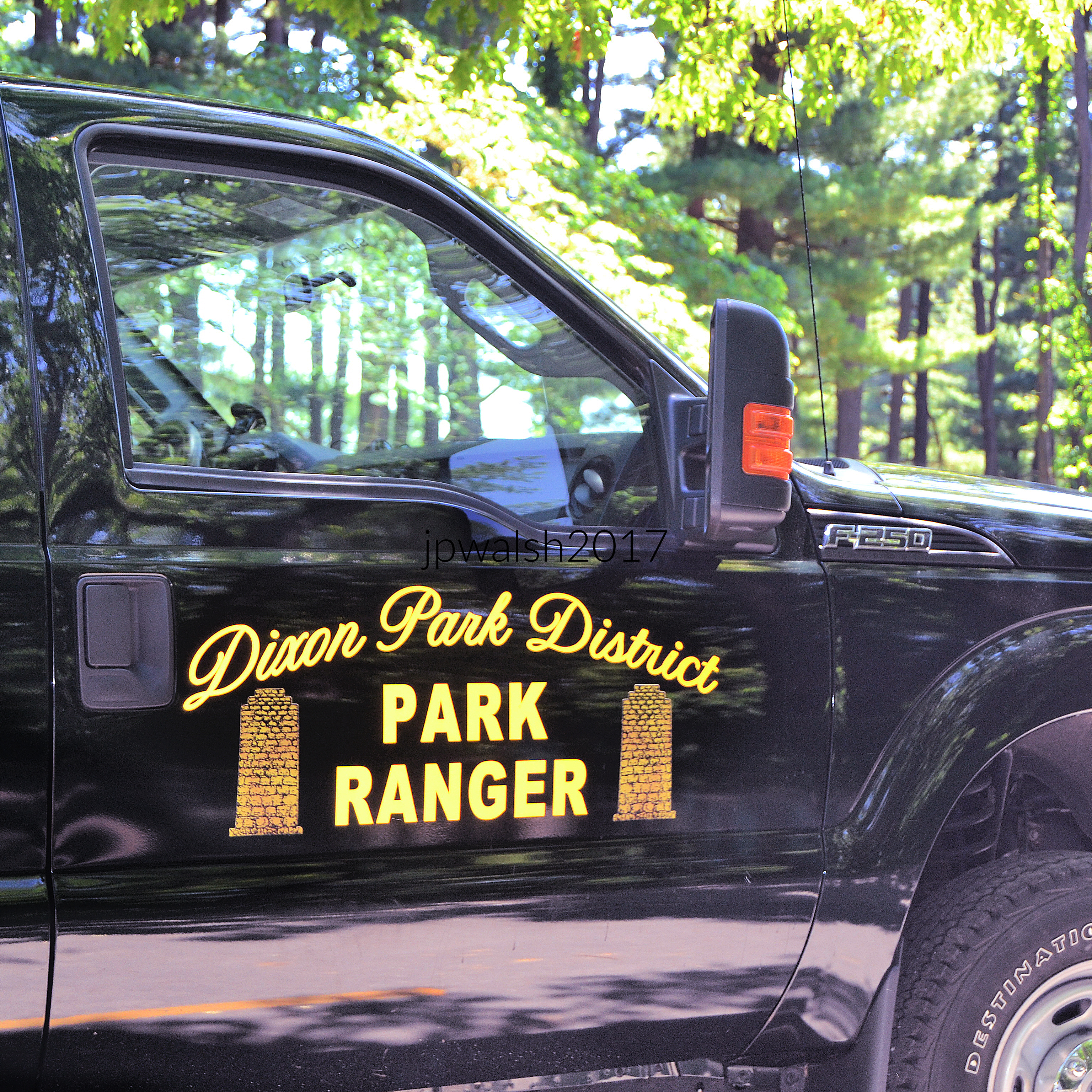
This helicopter (above and below) wears five Purple Hearts carved from enemy ground fire in Vietnam — battered, scorched, and shot to pieces, yet every time it clawed its way back through the smoke, it delivered its crew home alive. In Dixon’s (Illinois) Veterans Memorial Park founded in 2001 the 1967 AH-1F Cobra Attack Helicopter Gunship (serial #67-15475) was issued to the 7th Squadron of the First Calvary Divisions Aviation Group for its entire tour of duty. This helicopter arrived in Vietnam in March 1967. Following 1142 combat hours flown, the helicopter was damaged on July 27, 1969, because of a weapons malfunction. At 1792 hours flown it was shot down on February 6, 1970, by heavy enemy ground fire while providing armed escort to medivac helicopters with both crewmen wounded. On April 15, 1970, at 1954 hours flown, it was damaged while providing direct fire support to infantry. On July 13, 1970, it was shot down by small arms fire while providing escort at 2092 hours. At 2471 hours, on January 19, 1971, it was severely damaged by gunfire while providing direct escort protection to ground troops. On July 6, 1971, it was damaged by heavy ground fire on an armed escort mission at 2745 hours flown. see – Cobra Attack Helicopter – Veterans Memorial Park & Museum – retrieved April 13, 2025.

June 2017. 6.18mb DSC_0821 (2)
June 2017. 3.12mb DSC_0751.

On June 5, Ronald Reagan’s death day, Honor Guard gather at the Reagan Boyhood Home in Dixon, Illinois.

June 2017. 4.13mb DSC_0845.

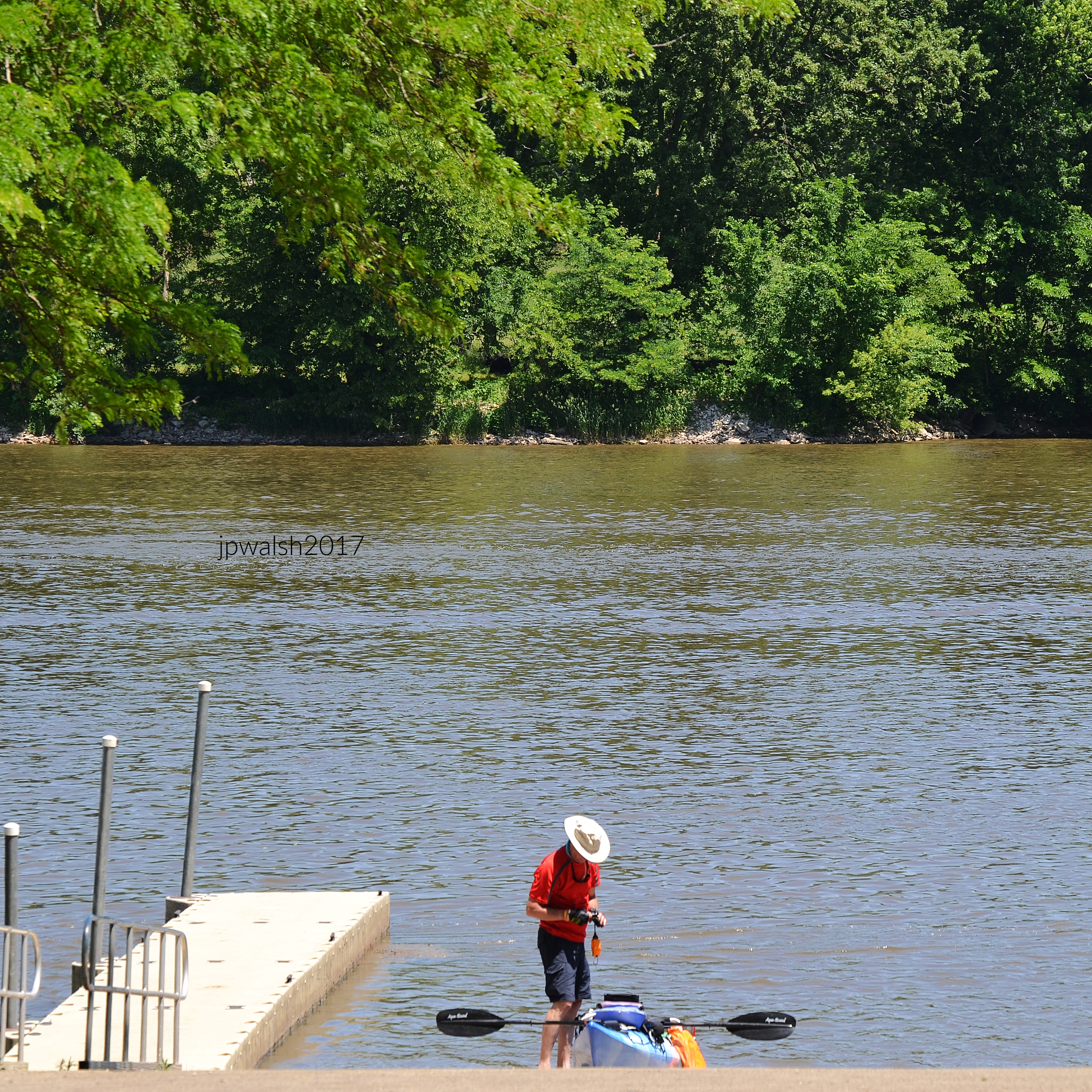
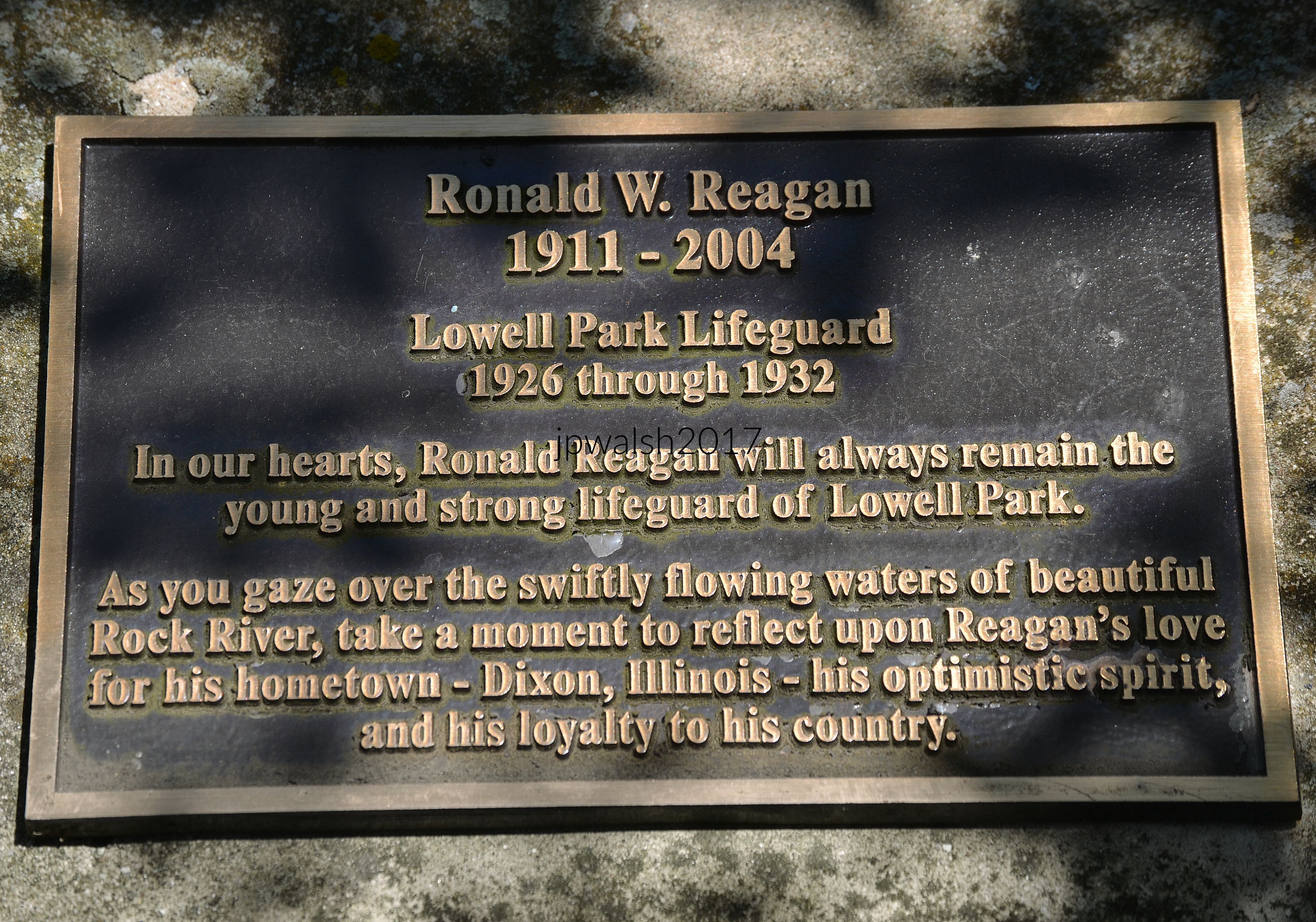
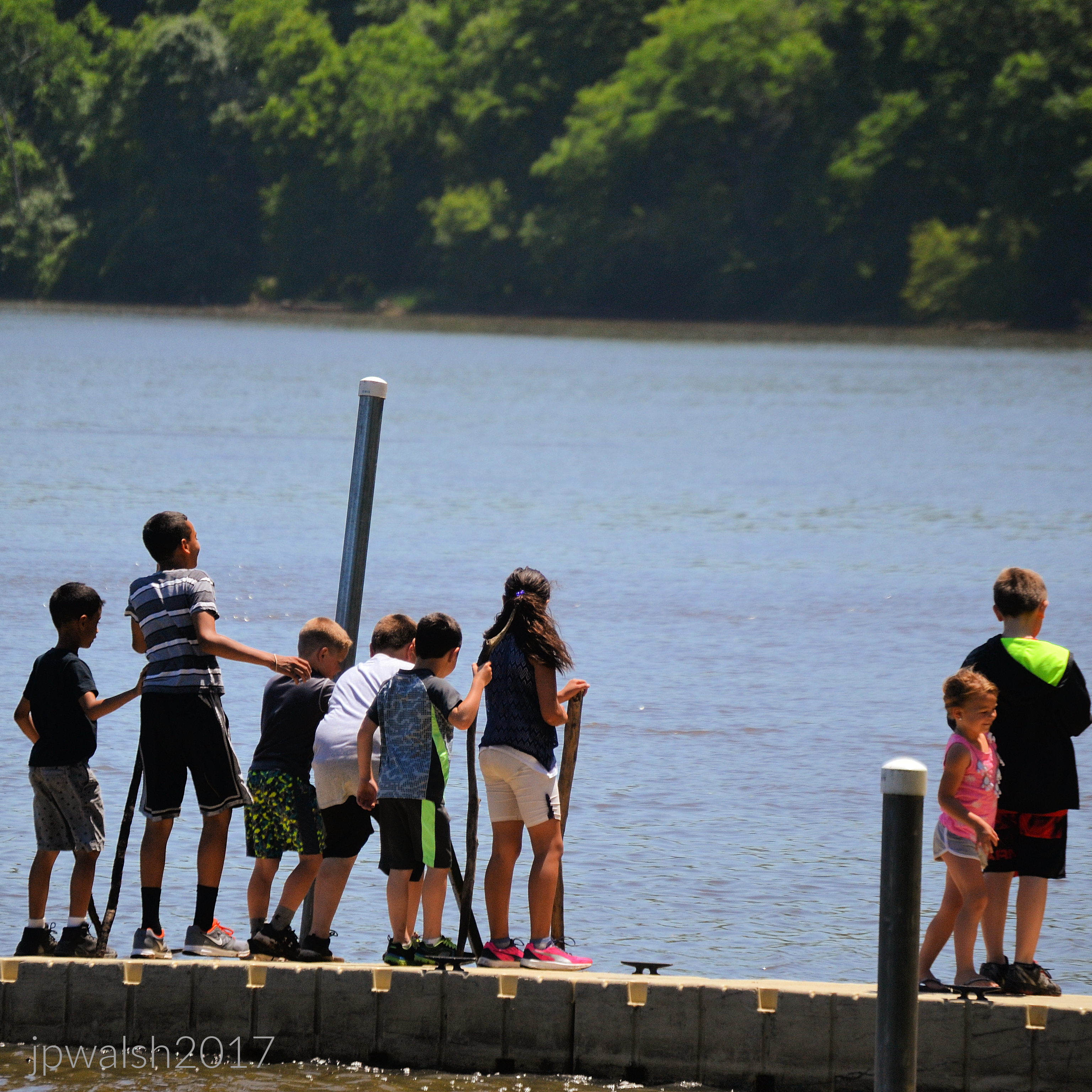
Reagan was a lifeguard at Lowell Park from 1926 to 1932. The original 200-acre public park opened in 1907 and began Dixon’s park system with the objective to preserve scenic beauty and establish civic beautification. From the start, Lowell Park attracted large numbers of people to its location along the Rock River. In this area, the valley of the Rock River contains bluffs and unique rock outcroppings that create a natural beauty. More than 100 years later, Lowell Park has maintained its distinctive scenic and natural recreational resources for free public use.

June 2017. 5.73mb DSC_0918.

Lowell Park predated the development of Illinois state parks in areas of outstanding natural attractions by many years. Lowell Park is the only public place in the Dixon area that preserves remnants of the Boles Trail established in 1826 from Peoria, Illinois, to Galena, Illinois. The trail was replaced in popularity by the famous Kellogg Trail established in 1825 east of the Boles Trail route. See – https://historyillinois.org/boles-trail-the/ – retrieved March 3, 2025.

Lowell Park Dixon, Illinois” by Kepper66 is licensed under CC BY-SA 3.0.

Lowell Park, Dixon’s first recreational park, was gifted in 1906 by Carlotta Lowell who was the niece of James Russell Lowell (1819-1891), a famous Boston (Cambridge) poet. The family came west on the invitation of Alexander Charters, a wealthy New York businessman, who purchased a large, wooded estate overlooking the river north of Dixon in 1837 and named it Hazelwood. His home later became the estate of Mr. & Mrs. Charles R. Walgreen, founder of the drug store chain that bears that name. Charles Lowell. a guest at Hazelwood, purchased the adjacent tract of land to live. Lowell married Josephine Shaw, also originally of Boston, and then of Staten Island in New York. When the Civil War broke out, Charles enlisted and was promoted to the rank of colonel and was killed in 1864 at the Battle of Cedar Creek in northern Virginia. Carlotta never knew her father as she was born after his death and the family never lived on their land in Dixon. In 1874, they moved to New York City and stayed there the rest of their lives. After her mother died, Carlotta offered the property in 1906 to the City of Dixon for a park in memory of her parents.

June 2017. 5.11mb DSC_0780.

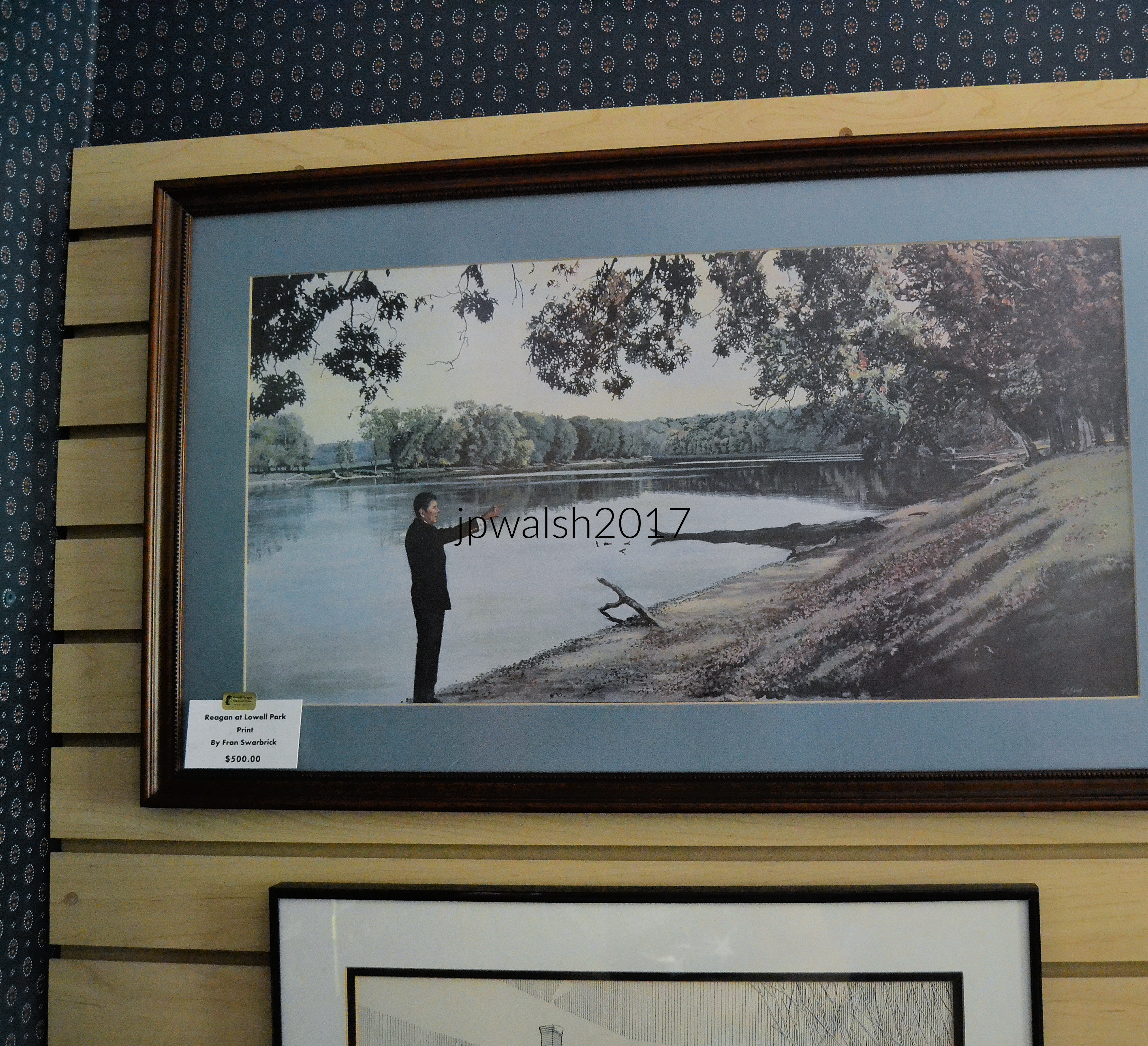
40th U.S. president Ronald Reagan visiting the Rock River in Lowell Park where he was an effective and beloved lifeguard for seven consecutive summers. In July 1921 a longer dock had been installed at the beach, extending 75 feet into the river with a springboard platform. The new bathhouse was built in 1922 that accommodated hundreds of bathers. Electricity was installed at the park in 1922 with lighting that allowed the beach to remain open until after dark. Over those summers, Reagan saved 77 swimmers from drowning. Obviously proud of his achievement, President Reagan often showed his Oval Office visitors a picture of the Rock River while telling them that his lifeguarding there was “one of the best jobs I ever had.”

Reagan at Lowell Park 1927. Ronald Reagan as lifeguard getting into a canoe in Lowell Park, 1927. Public Domain. https://www.reaganlibrary.gov/archives/photo/ronald-reagan-lifeguard-getting-canoe-lowell-park-1927-32 – retrieved March 4, 2025.

June 2017. old beachfront. 5.73mb DSC_0879.

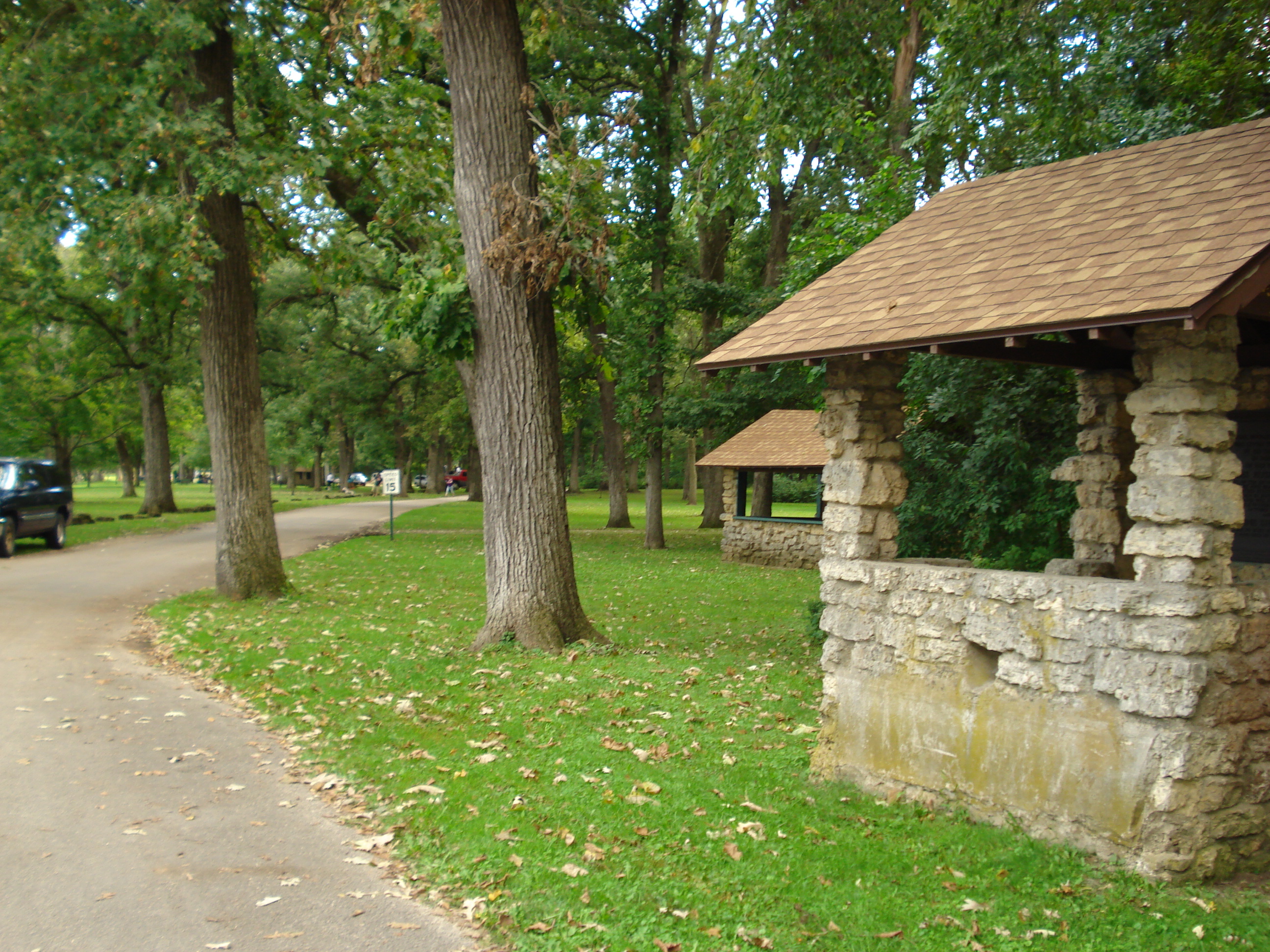
The original 200 acres of Lowell Park opened to the public in 1907. The park was designed by the Olmsted Brothers, a nationally prominent architecture firm headed by the sons of Frederick Law Olmsted. Lowell Park was designed in the American Romantic style which is characterized by its emphasis on natural scenery, native plant materials, native building materials, curvilinear roads, and minimum formality. In 1959 the beach was finally closed after ten years of declining usage due to the opening of Memorial Pool in Vaile Park in the city of Dixon. The Lowell Park bathhouse was used for storage as its concession stand continued to operate until the late 1980s.

June 2017. Lowell Park was designed in the American Romantic style by the Olmsted Brothers. 7.24mb DSC_0916 (1)

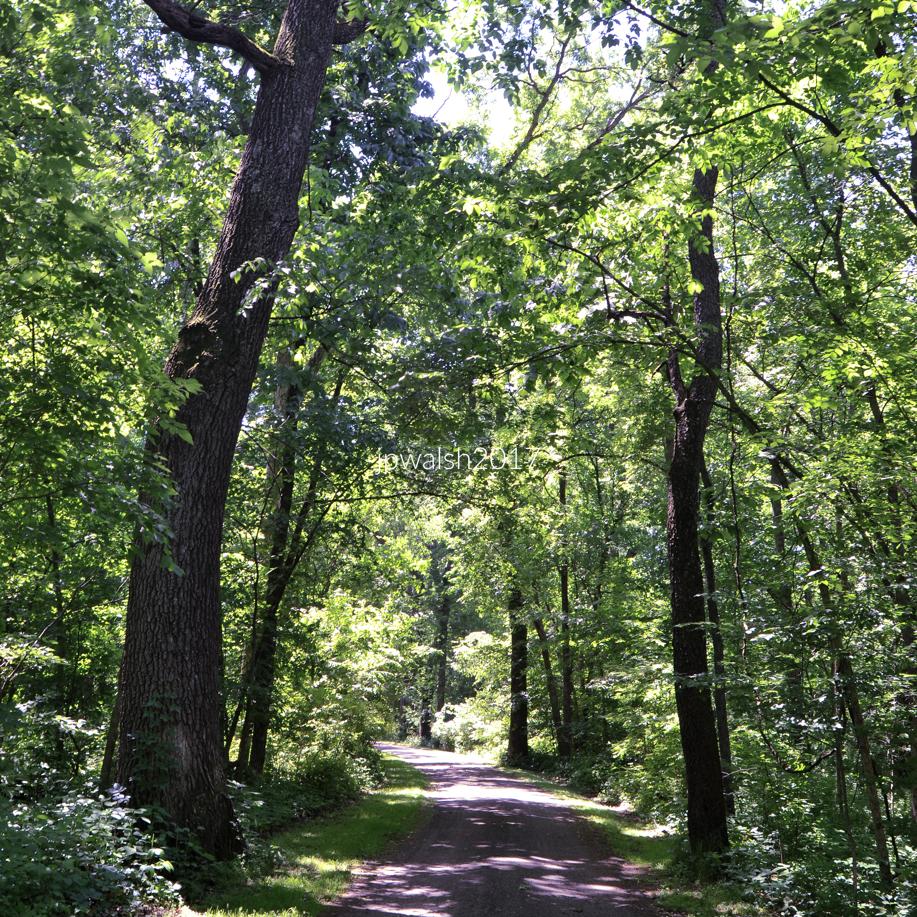
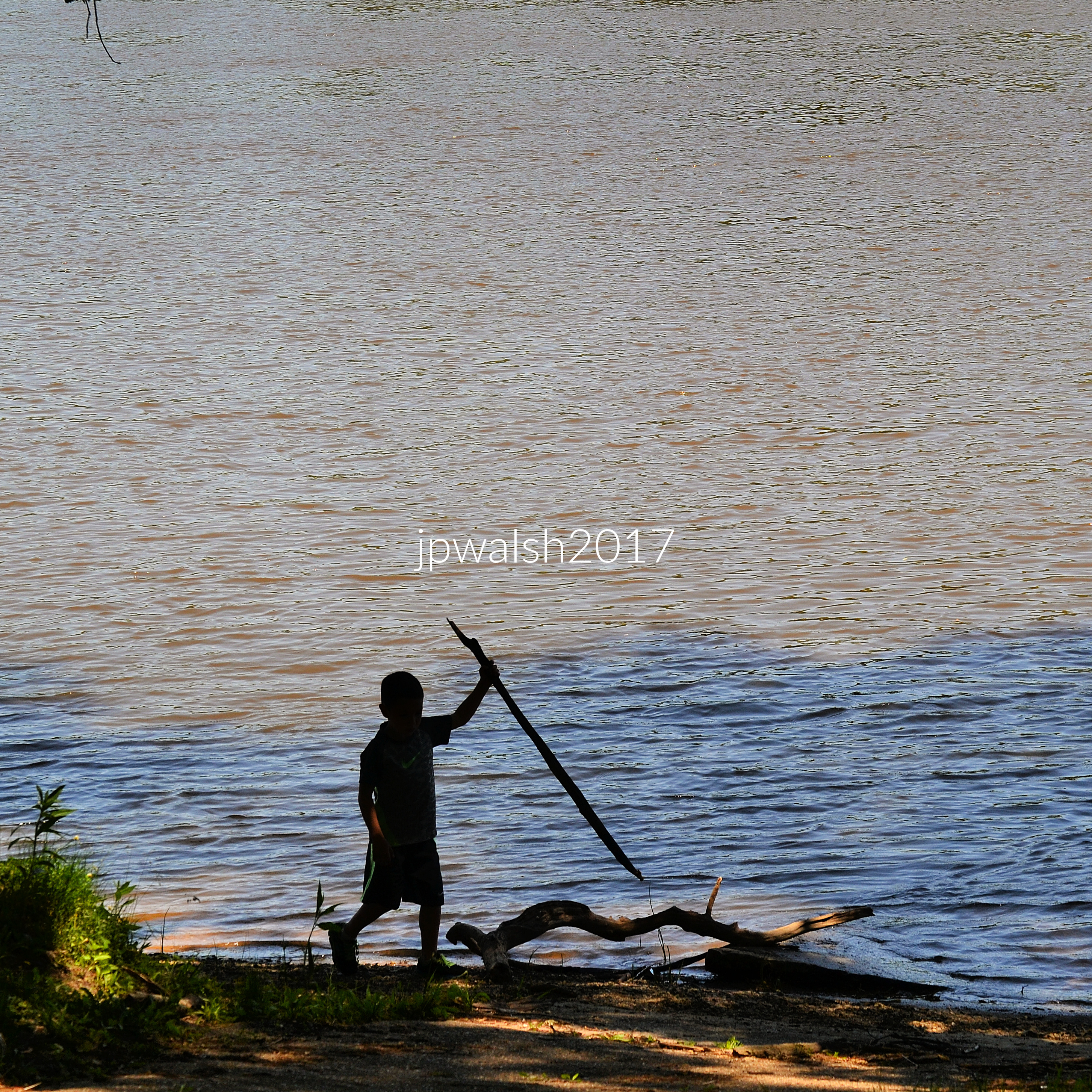
Rock River at Lowell Park is still the hub for recreational activities as it has been for over a century.

June 2017. 5.25mb DSC_0901.

President Reagan on his lifeguard years in Dixon: “One of the Best Jobs I Ever Had.”

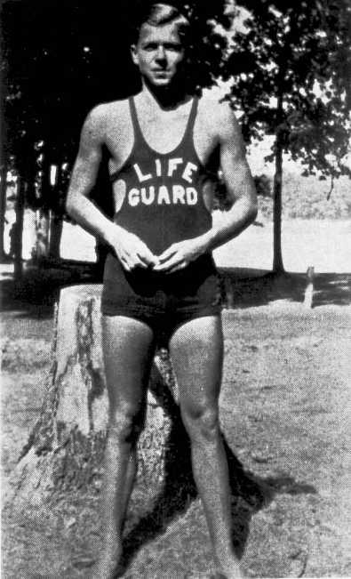
Ronald Reagan as a lifeguard at Lowell Park in 1927. Public Domain.

June 2017. Lowell Park, Dixon, IL. DSC_0882
June 2017. Diving top with changing rooms and concession behind. Lowell Park, Dixon, IL. 5.38mb DSC_0896

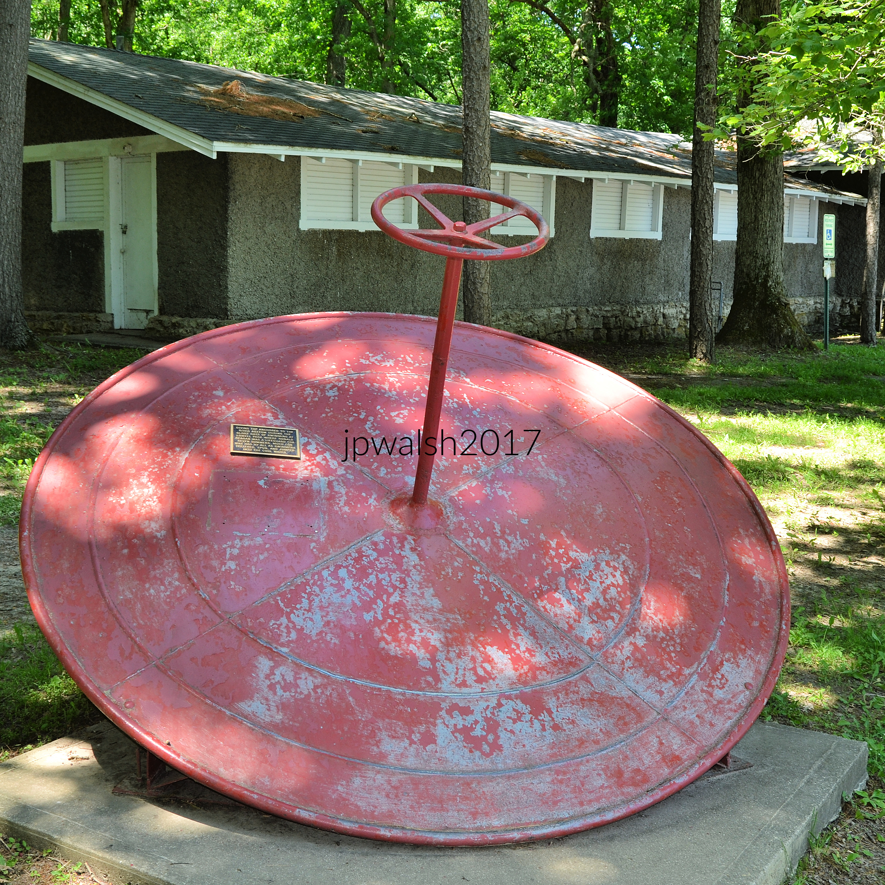
Bus service from Dixon city to the park started in 1921. This diving top was anchored to the river bottom during its swimming hole glory days when Reagan was lifeguard. Swimmers teetered, spun and jumped into the water during hot Illinois summers which Reagan knew and loved. The one-story bathhouse behind it was designed and built in 1922. When Reagan was a lifeguard the building served as the concession stand and the check area for clothing baskets. Under a hipped roof, the men’s wing was to the south and women’s wing out of sight to the west. The architect of the bathhouse is unknown.  Native stone was used from the ground to the height of the concession building’s serving counters and for the foundations of the two wings. Above that the walls were stucco on the exterior. All stonework was coursed and roughly squared. It was ventilated by raising the hinged board covers of the screened window openings. The steel-supported roof was covered originally with black-blue slate shingles that were replaced in 1934 with asphalt shingles. The overhang is broad with exposed rafters.

June 2017. Lowell Park, Dixon, Illinois. 3.53mb DSC_0877

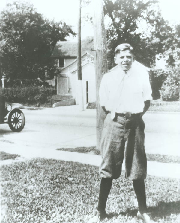
Ronald Reagan in Dixon, Illinois, in the early 1920’s. Public Domain.

June 2017. 5.93mb DSC_0774.

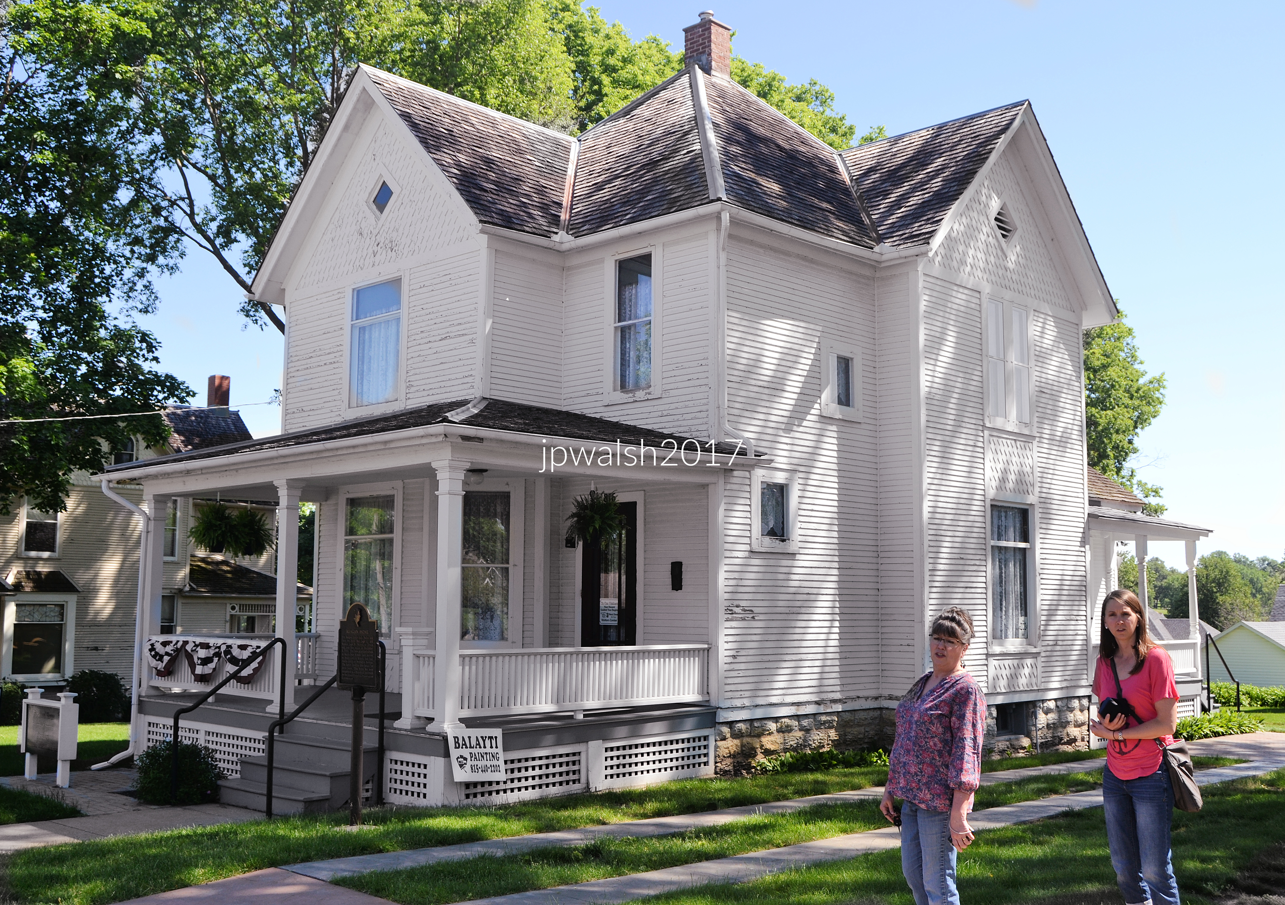
The Reagans settled in this rented house at 816 S. Hennepin Avenue in Dixon, Illinois, on December 6, 1920. The family of father Jack, mother Nelle, and 12-year-old Neil and 9-year-old Ronald lived here for three years. From 1921 to 1924, Neil and Ron attended South Side/Central School which still stands four blocks north of the house and is now the Dixon Historic Center. Reagan often walked along Hennepin Avenue going downtown to the Dixon Public Library at 221 South Hennepin Avenue and the First Christian Church at 123 South Hennepin Avenue where both Neil and Ron were baptized on June 1, 1922. Nelle taught Sunday school and sang in the church’s choir. Ronald and his mother were members of the Disciples of Christ church until 1937. Between 1924 and 1930, the Reagans lived in a rented house at 338 W. Everett Street in Dixon. Reagan lived in that house in Dixon when he was home from college after he began attending Eureka College in September 1928.

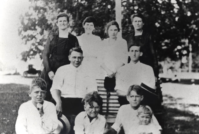
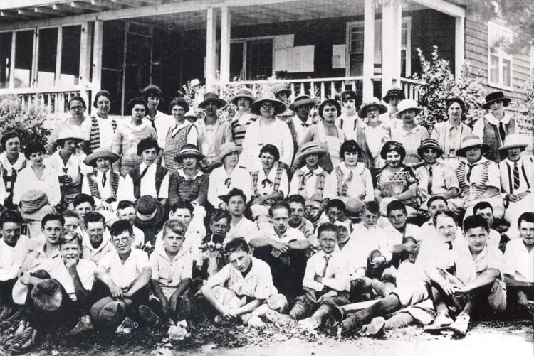
Reagan 1920s with family. Ronald Reagan sitting (hand on chin in front row) posing with other family members, Neil Reagan at far right (front row), Jack Reagan (middle row at left), Nelle Reagan (last row, second from left), Illinois. Public Domain.

Ronald Reagan sitting (hand on chin in front row) with other golf caddies for the Lincoln Highway Ladies Golf Tournament in 1922 in DeKalb, Illinois. Public Domain.

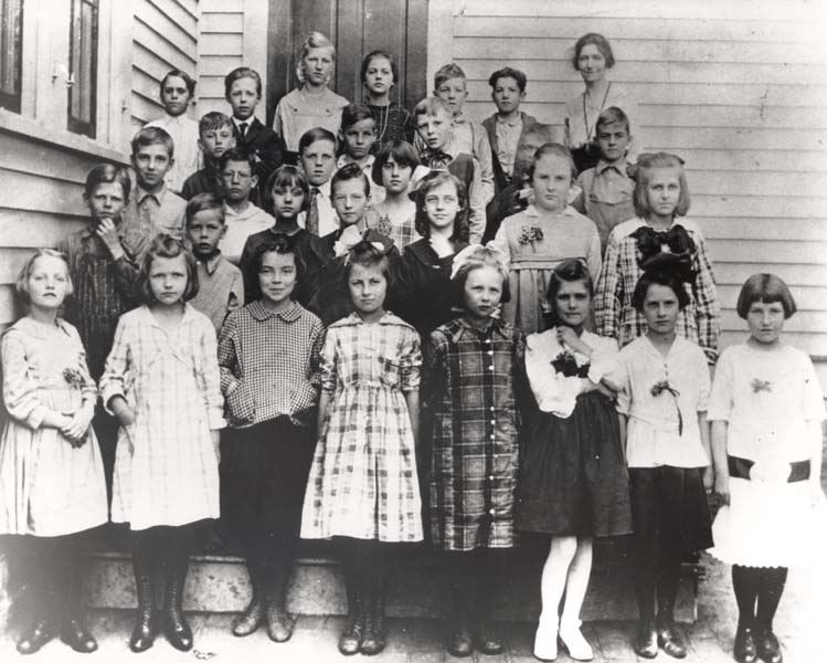
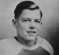
Reagan (second row, left) in 4th grade in Tampico, Illinois. Reagan was born in Tampico, Illinois, on February 6, 1911 in a second-floor apartment at 111 Main Street and, until 1914, at 104 W. Glassburn Street. Afterwards the family moved in sequence to Chicago, Galesburg, and Monmouth until they returned to Tampico in 1919-1920 and ultimately to Dixon in early December 1920. Reagan’s father was an alcoholic and they moved around a lot. As a young man Reagan became a lifesaver. Public Domain.

Brothers Neil and Ron Reagan attended South Side/Central School in DIxon, Illinois. The school building still stands at 205 W. 5th Street, four blocks north of the Boyhood Home. It is now the Dixon Historic Center.Dixon Illinois ~ The Dixon Historic Center ~ Exhibits devoted to President Ronald Regan” by Onasill ~ Bill is licensed under CC BY-NC-SA 2.0.

June 2017. Inside the Reagan Boyhood Home, Dixon, Illinois. 4.90mb DSC_0778 (1)

June 2017. Veterans Memorial Park, Dixon, Illinois. 6.41 mb DSC_0827.

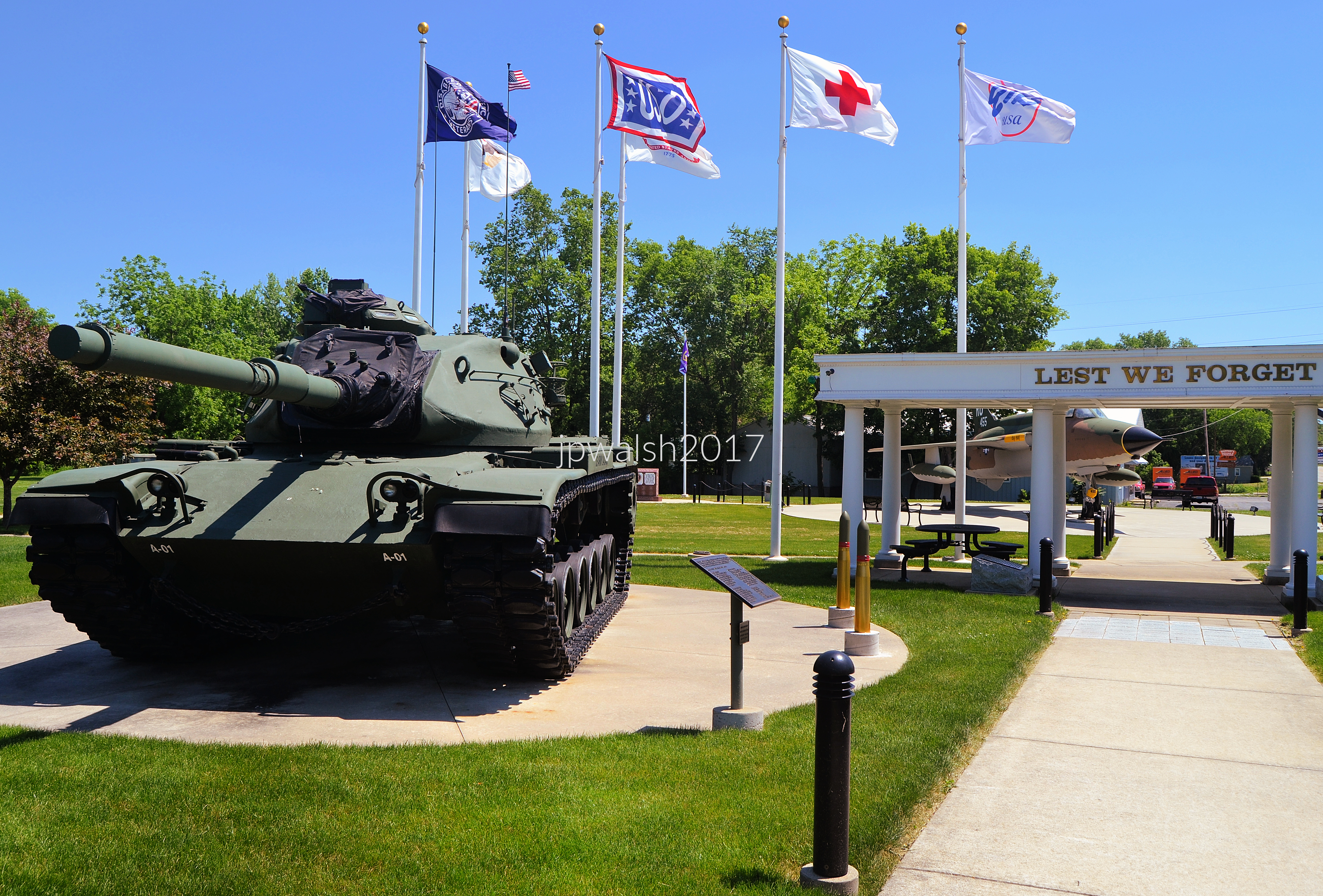
The M60 tank is designed as one of the main assault vehicles of an Armor/Mechanized Infantry/ Infantry Division. It weighs about 105,000 pounds unloaded and has a 64,000 pound payload. The tank can travel at top speeds of 30 m.p.h. and can travel nearly 300 miles.

June 2017. Veterans Memorial Park, Dixon, Illinois. 7.05mb DSC_0831.

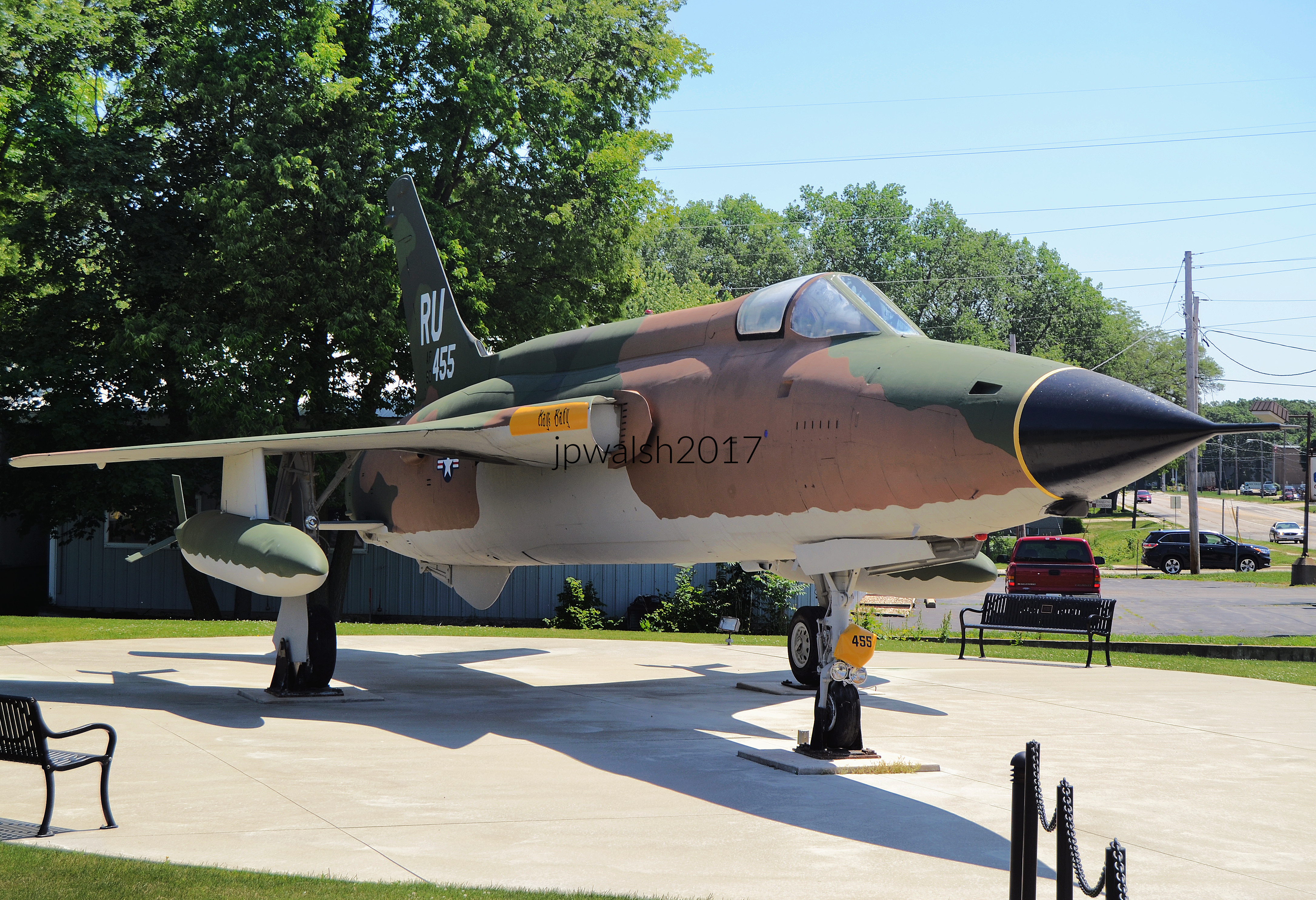
Republic F-105D Thunderchief (serial #60-455) was a new aircraft that served the U.S. Air Force from 1958 to 1984. This specific aircraft fought in Vietnam between 1968 and 1970. It was stationed at Takhli Airforce Base in Thailand with the 355 Tactical Fighter Wing that was established in April 1962 at George AFB in California and transferred to Thailand in 1965. This F-105D Thunderbird was one of 833 airplanes manufactured by Republic in Farmingdale, New York, with over half the fleet lost in combat or due to mechanical failures. With 610 built, this particular warbird was the definitive production model with all-weather capability because of advanced avionics, including AN/APN-131 navigational (Doppler) radar. This aircraft was retired with almost 6000 flying hours and two men who had flown it receiving the Medal of Honor. The plane’s maximum range is 2390 miles at a maximum ceiling of 48,500 feet and reached speeds of supersonic Mach 2 (1,534 m.p.h.) at over 36,000 feet. In addition to a Vulcan Gatling Gun the plane’s payload includes 750-pound conventional bombs (16 of them) or one nuclear bomb.

June 2017. 8.26 mb DSC_0803.

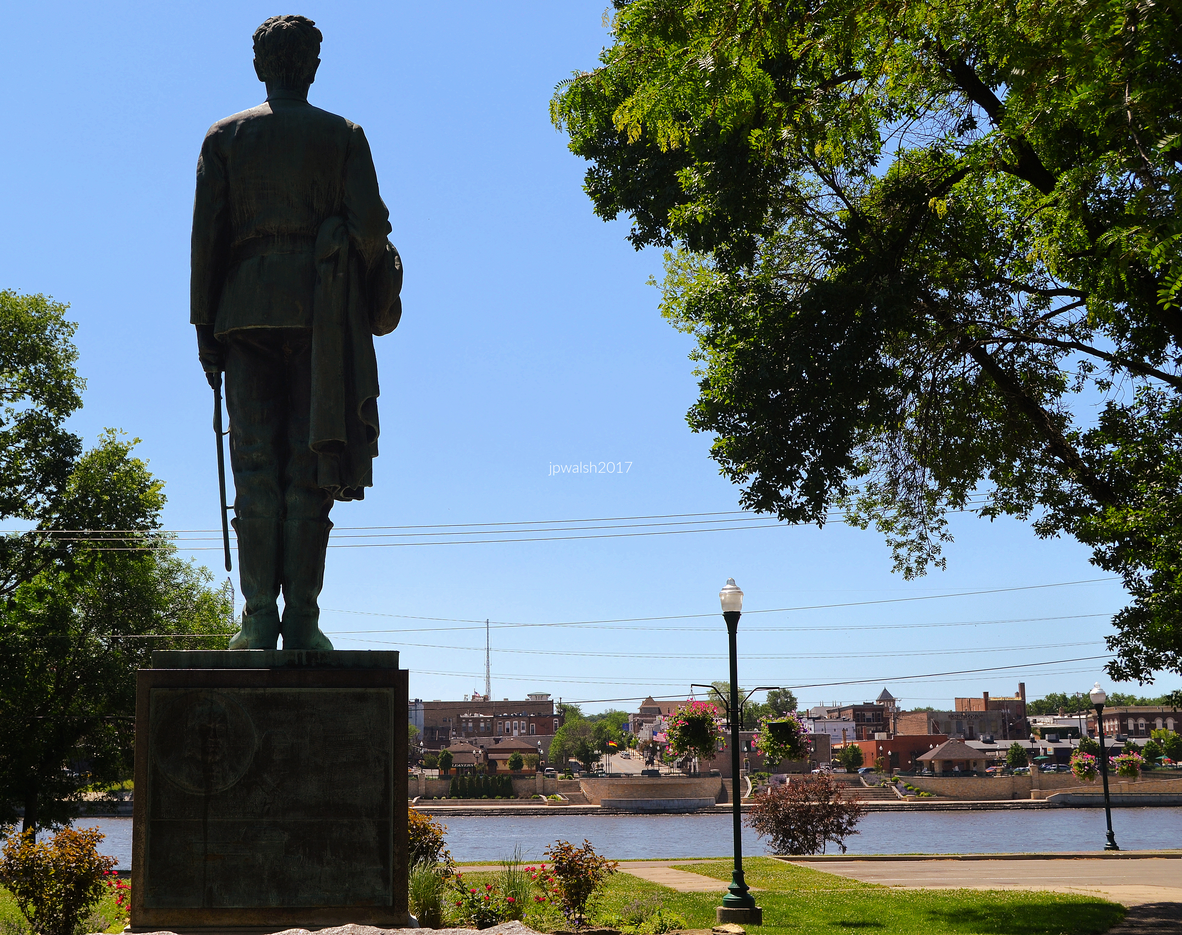
Capt. A. Lincoln, 16th president of the U.S., looking onto the Rock River in Dixon, Illinois, This 1930 statue by Leonard Crunelle (1872-1944) Reagan would have seen and known while living in Dixon. Young Lincoln enlisted in the Illinois Volunteers on April 21, 1832 and, following more enlistments, finally mustered out of military service on July 10, 1832. Across the Rock River is the modern Reagan statue.

June 2017. 4.37mb DSC_0785.

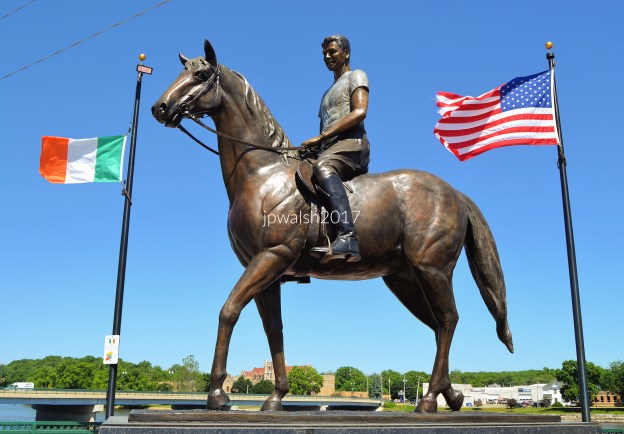
Ronald Reagan (1911-2004) lived in Dixon, Illinois from 1920 to 1933. Reagan always referred to Dixon as his “hometown.” Reagan made several visits to Dixon after he lived here, even when he was President of the United States. The statue is on the banks of the Rock River which is the same waterway where Reagan saved 77 lives as a lifeguard upstream at Lowell Park.

June 2017. 3.38mb DSC_0783.

After Reagan’s death in 2004 local donors commissioned this larger-than-life-sized statue of Dutch Reagan on a palomino horse and gifted it to the City of Dixon. It was dedicated to the eradication of Alzheimer’s that was a foe that President Reagan had to battle in last years.

June 2017. 5.28mb DSC_0786 (1)

Reagan in DIxon in the early 1920’s. Public Domain.

In 1982, President Reagan told the Eureka College audience, “Everything that has been good in my life began here.”

September 2016. Eureka College’s Burrus Dickinson Hall built in 1858. 3.87 mb

On campus at Eureka College in Eureka, Illinois, about 90 miles south of Dixon, where Reagan lived. The college, affiliated with the Disciples of Christ of which Ronald Reagan was a member, was founded in 1855. At the time of its founding Eureka was one of a handful of U.S. colleges that was co-ed. In 1856 Abraham Lincoln spoke on campus. After he graduated Reagan returned for campus visits at least a dozen times and served on its board of trustees. Reagan attended Eureka College from 1928 to June 10, 1932, when he graduated as the elected student body president with a degree in economics/sociology. Eureka College is the smallest college or university in American history to graduate a future U.S. president with a bachelor’s degree. The school is in Woodford County in Illinois.

On May 9, 1982, President Reagan announced the START treaty proposal in the Reagan Gym at Eureka’s commencement exercises. It resulted in a bilateral treaty signed in 1991 between the U.S. and U.S.S.R. on the reduction and the limitation of strategic offensive arms including nuclear warheads and intercontinental ballistic missiles and heavy bombers.

Ronald Reagan is the only U.S. president who was born, grew up and received his education in the state of Illinois.

September 2016. Part of the Berlin Wall. Eureka College. 2.40mb DSC_0493 (3)

Of Dixon the Gipper once said: “It was the place I really found myself.”

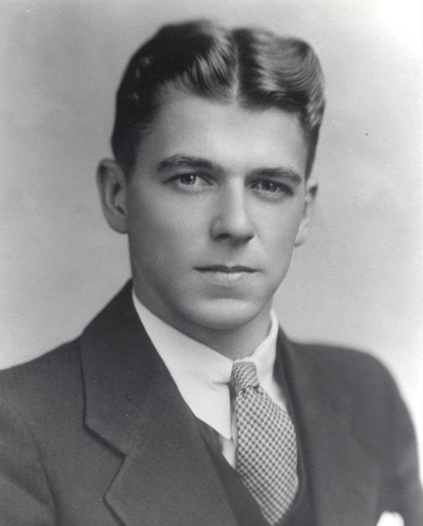
Portrait of Ronald Reagan in 1934 the year after he left Dixon, Illinois. His career led to Hollywood, California as a film actor and Screen Actors Guild president; to Sacramento, California as 33rd Governor of California (1967-1975); and to Washington, D.C., as 40th President of the United States of America (1981-1989). But it was to Dixon, Illinois, that Reagan always returned with its fond memories. Reagan graduated from Eureka College, a liberal arts school affiliated with the Disciples of Christ, in 1932 where he was active in sports and drama and elected student body president. Reagan’s first job was as a sports radio broadcaster in Davenport, Iowa, for Big Ten football games. Afterwards he was a sports announcer for Chicago Cubs’ baseball games on WHO-AM in Des Moines. Reagan arrived in Hollywood in 1937 and was cast in his first feature film Love is on the Air for Warner Bros. where he gets to play a newscaster. Fair use.

In Love is on the Air (1937) Ronald Reagan made his screen debut as a crusading radio reporter who takes on civic corruption.

This explanatory article may be periodically updated.

SOURCES-

https://web.archive.org/web/20171014084448/http://gis.hpa.state.il.us/pdfs/223426.pdf – retrieved March 3, 2025.

https://www.dixongov.com/content/dixon-community/reagan-s-roots-run-deep-in-the-dixon/ – retrieved March 4, 2025.

https://www.reaganlibrary.gov/archives/audiovisual/white-house-photo-collection-galleries/early-ronald-reagan-and-family – retrieved March 4, 2025.

https://www.reaganlibrary.gov/reagans/ronald-reagan/residences-ronald-w-reagan – retrieved March 4, 2025.

https://www.wifr.com/2024/08/23/what-is-ronald-reagans-connection-dixon/ – retrieved March 4, 2025.

Fair Use. Reagan Library – https://www.reaganlibrary.gov/public/2021-08/E24-1_0.jpg?KN9FfhLcWyx9eRcpUu744qKrRtzZnsV6= – retrieved March 4, 2025.

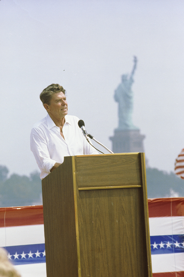
Reagan giving a speech in Liberty State Park in Jersey City, NJ on September 1, 1980. On a personal note, I met Ronald Reagan at the Palmer House in Chicago in June 1980 during a press conference. He was gracious and had movie star looks: tall and handsome. Reagan was elected the 40th U.S. president in a landslide over Jimmy Carter in November 1980 and re-elected in 1984. I later met Jimmy Carter in Chicago at a book signing in the 1990’s.

June 2017. 5.49 mb DSC_0776 (1)

Author and wife at Reagan Boyhood Home, Dixon, Illinois.

June 2017. 3.20mb DSC_0734 (2).

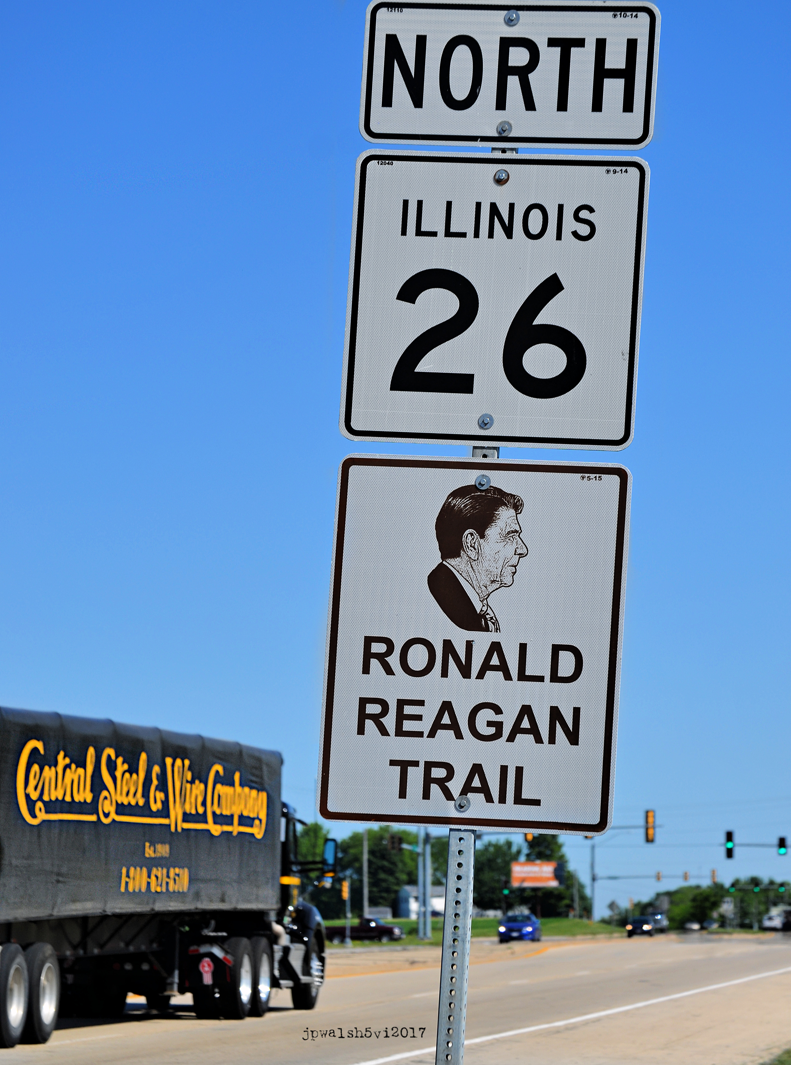
The Ronald Reagan Trail (IL-26) is a route in Illinois that follows sites of interest associated with the 40th president of the United States who was born in Tampico, Illinois and grew up in Dixon, Illinois. Route 26 originally ran north-to-south for about 25 miles from Freeport, Illinois to Polo, Illinois. In 1937, IL-26 was extended about 15 miles north to the Illinois-Wisconsin state line and about 15 miles south to Dixon, Illinois. In 1969, IL-26 was extended almost 100 miles south from Dixon to East Peoria, Illinois.

June 2017. Rock River at Lowell Park, Dixon, Illinois. 4.93 mb DSC_0865 (1). Author’s photograph.

My Street Photography: U.S. 1970s-2000s.

FEATURE image: September 1994. Montaña de Oro State Park. San Luis Obispo/Los Osos, CA. 80%

Sonoma County, California (1987):

June 1987. Jenner, CA. 868kb
June 1987. Sonoma Co., CA. 205kb
June 1987. Near Jenner, California.
June 1987. St. Teresa of Avila Church, 17120 Bodega Rd., Bodega, California. The church was built by shipbuilders in 1860 on land donated by an Irish-American politician from San Francisco. In 1953 Ansel Adams (1902-1984) photographed the church in black and white. Film director Alfred Hitchock (1899-1980) attended Mass in the church during the filming of “The Birds.” The Bodega schoolhouse immediately behind the church was used by Hitchcock for the schoolhouse scene in the 1963 horror-thriller film. An active schoolhouse in 1963, the church can also be seen in the classic film. 93% 7.89mb

Montaña de Oro State Park, San Luis Obispo County, California (1994):

September 1994. Montaña de Oro State Park. San Luis Obispo/Los Osos, CA. 80%

Glacier National Park, Montana (1994):

June 1994. Glacier National Park (Montana). 60%

Coronado National Memorial, Cochise County, Arizona (U.S.- Mexico border) (1988):

October 1988. U.S.-Mexico border. Behind me is Mexico. Coronado National Memorial, Cochise County, Arizona. Here, at Montezuma’s pass at 6,700 feet, Spanish conquistador Francisco Vásquez de Coronado (1510-1554) and his conquistadores first set foot in what is now Arizona in 1540 — less than 50 years after Columbus’ discovery of America and 67 years before the founding of Jamestown by the English. 1mb.

Rapidan River, near Chancellorsville, Virginia (2001):

June 2001. Rapidan River near Chancellorsville,VA, The Rapidan River is the largest tributary of the Rappahannock River. These two rivers in the state of Virginia converge just west of the city of Fredericksburg, VA. The Rapidan River was the scene of severe and significant fighting in the Civil War including at Ely’s Ford (August 1862 & April-May 1863), Kelly’s Ford (March 1863), Chancellorsville (May 1863), Brandy Station (June 1863), and the Battle of the Wilderness (May 1864). 75%

North Cascades Highway, Washington (1993):

September 1993. Washington Pass (Diablo Lake), WA. A popular spot, Diablo Lake is one of the scenic bodies of water in Washington Pass which, at over one mile above sea level, is the highest point on the North Cascades Highway in Washington State. On either side of the pass are glacier-carved valleys whose creeks eventually drain into the Columbia River. According to the Pacific Northwest National Parks and Forest Association and the U.S.D.A. Forest Service (Pacific Northwest Region), when the North Cascades Highway opened in 1972 more people could easily access the highest and wildest mountains in the state than ever before. Before 1972 Native Americans, prospectors, trappers, mountaineers and hearty backpackers were the only ones who explored a region that took about four days to cross on horseback. Diablo Lake’s distinctive color is caused by fine rock particles, or “glacial flour,” which refracts light. These particles are created as rocks erode and pour into the lake by wind and glacial streams. 60%.
September 1993. Washington Pass, Pyramid Peak (7182 feet/2189 meters), North Cascades National Park, WA 60%
September 1993. Washington Pass, State Route 20, WA. State Route 20, or the North Cascades Highway, cuts through mountain wilderness at Washington Pass. The highway is Washington State’s longest, winding its way over 400 miles traveling from U.S. Route 101 at Discovery Bay on the Olympic Peninsula to the state border with Idaho. 65% (10)
September 1993. Washington Pass, Liberty Bell (7720 feet/2353 meters), North Cascades National Park, WA. 80% (10)

Mount Rainier National Park, Washington (1991):

July 1991. Mt Rainier National Park, WA.
July 13, 1991. Narada Falls, Mt Rainier National Park, WA

Near Hollywood, Florida (1987):

December 1987. Hollywood, FL.

Edison/Ford Museum, Fort Meyers, Florida (1999):

March 1999. Bust of Thomas Edison (1847-1931), Edison/Ford Museum, Fort Meyers, Florida, Completed in 1886, American inventor Edison had his winter home and botanical laboratory in Fort Meyers until his death in 1931. Edison and car manufacturer Henry Ford (1863-1947) lived next door to each other in Florida.

Cape Neddick Light (1879), York, Maine (1989):

July 1989. Cape Neddick Light, 1879, York, Maine. Seen from Sohier Park, Cape Neddick Light was built in 1879  on a “nubble” of land about a football field apart from the mainland, The light has been in continuous use since the presidency of Rutherford B. Hayes and still has it original Fresnel lens. It was placed on the National Register of Historic Places in 1985. As necessity is the mother of invention, the lamp was electrified in 1938 so that its oil-lit lamp didn’t blow out during “Down East” winter storms.

Kennebunkport, Maine (1989):

July 1989. Ocean Avenue, Kennebunkport, Maine. 50%.

Penobscot Bay, Camden, Maine (1989):

July 1989. Penobscot Bay, off Camden, Maine. 5.27mb Scan_20250626 (21)

Hilton Head Island, South Carolina (1989):

September 1989. Harbour Town, Hilton Head Island, South Carolina.

Charleston, South Carolina (1989):

September 1989. B&B Hosts, Charleston, South Carolina, South Carolina.

Savannah, Georgia (1989):

September 1989. Savannah Theatre, Savannah, Georgia. Standing at 222 Bull Street across from Chippewa Square, a theatre has stood on this site since 1818. The Arte Moderne movie house was built in1948 by Robert E. Collins and Carl E. Helfrich, architects active in Georgia and Florida. It was owned by Weis Theatres who also had a movie house in Atlanta, Georgia. Since 1981 the nearly 1000-seat theatre has changed hands several times. When this photograph was taken in 1989 the theatre was downsized to about 350 seats and owned by the Savannah Theatre Company (STC) and used for live performances. SOURCE: https://visitsavannah.com/profile/chippewa-square/6117 and
https://cinematreasures.org/theaters/686. (20)

Cabrillo National Monument, San Diego, California (1999):

January 1999. San Diego, CA. The California Conservation Corps (CCC) at the end of its work day. The CCC was founded by Gov. Jerry Brown in 1976. It is a pay-as-you-go government agency that gives youth the opportunity to work in a job that is mostly outdoors as well as provides some scholarships. 75%

Sunset Cliffs Natural Park, San Diego, California (2000):

October 2000. Sunset Cliffs Natural Park, San Diego, California.

Lake Cachuma, California (1994):

September 1994. Lake Cachuma, CA. Cachuma Lake is a reservoir in the Santa Ynez Valley of central Santa Barbara County, California on the Santa Ynez River along California State Route 154. The artificial lake was created to meet the water needs of this part of California. The Cachuma site for a new dam was formally approved in December 1947 with a referendum endorsing it overwhelmingly in November 1949. The dam began in 1950 and was completed by the U.S. Bureau of Reclamation in 1953. Lake Cachuma finally spilled in April 1958. The final price tag of the project would amount to over $43 million. 80% see – https://www.independent.com/2017/11/02/history-lake-cachuma/ – retrieved February 20, 2024.

The Art Institute of Chicago, Chicago, Illinois (1984):

September 1984. “Degas in the Art Institute of Chicago.” July 19- September 23, 1984 7.84mb 72%

Chicago, Millennium Park construction site (1998):

December 1998. Chicago. Behind us is the construction site for Millennium Park. Ground was broken in 1997 for the project in a northwest corner of Grant Park and completed in 2004. In 1999 it was announced that Anish Kapoor’s Cloud Gate (“The Bean”) – a mirrored stainless steel object roughly 66 feet long – would be installed in the park with the expectation that it would attract foot traffic. The Bean was unveiled in 2006. By 2016 Millennium Park was the most-visited site In the Midwest as it boasted more than 13 million visitors that year and generated about 20,000 hospitality jobs. see -https://www.cbsnews.com/chicago/news/millennium-park-midwest-tourism/ – retrieved February 19, 2024. (30)

Chicago, Daley Plaza, Clinton-Gore Rally, October 20, 1992:

 October 20, 1992. Chicago. Clinton-Gore Rally, The Democratic ticket for U.S. president and vice president was joined by Hillary Rodham Clinton and Tipper Gore. Also on the platform was Democratic Senate candidate, Carol Moseley Braun. All these candidates won their respective races that year. Clinton-Gore served two terms and Moseley Braun who was the first Black woman to serve in the U.S. Senate and first female U.S. Senator from Illinois served one term. see – https://www.c-span.org/video/?c4090960/user-clip-clintongore-campaign-speech-1992 – retrieved June 20, 2023. 75%
Clinton-Gore campaign button. “Bill Clinton – Al Gore Union campaign button HERE” by Mpls55408 is licensed under CC BY-NC 2.0.

Olana State Historic Site (1872), Hudson, New York (2000):

June 2000. Olana, the home of artist Frederic Church (1826-1900) and his wife Isabel Mortimer Carnes, a young beauty from Dayton, Ohio, and their four children. Church, a central figure in the Hudson River School of American landscape painters, was born in Hartford, Connecticut. In 1860, by then a successful married artist, Church bought 126 acres of farmland on a south-facing hillside near the town of Hudson. The area had been a sketching place he visited in 1840 with his teacher, Thomas Cole (1801-1848). Calling it “the Farm,” the Churches built the Olana mansion between 1870 and 1872. Today Olana is part of 250-acre State Historic Site along the picturesque Hudson River across from Catskill, New York. 65% see – https://www.olana.org/ – retrieved February 19, 2024.
Frederic Edwin Church, photograph by Mathew Brady. Library of Congress.

Sedona, Arizona (1989):

May 1989. Sedona, Arizona. 1.14 mb. By way of the leadership of then-Gov. Bruce Babbitt (1978-1987), a 286 acre area of a vast red sandstone canyon was designated as Red Rock State Park. It opened and was dedicated in October 1991. 1.14mb
May 1989. Holy Cross Chapel (1957), Sedona, Arizona. It was inspired and commissioned by local rancher and sculptor Marguerite Brunswig Staude (1899-1988) and dedicated in 1957. Architects for the project were Richard Hein and August K. Strotz of Anshen & Allen. Since the chapel is built on Coconino National Forest land a special use permit was needed which was secured for the project by Senator Barry Goldwater. The construction supervisor was Fred Coukos who built the chapel for $300,000 (about $3.5 million in 2024 dollars) over about 18 months. see- https://www.findagrave.com/memorial/212538307/marguerite-staude and https://www.chapeloftheholycross.com/history – retrieved February 20, 2014.
May 1989. Sedona, Arizona. 1.28mb
The author (left), as Communications Director of a national insurance association, was tasked to invite and facilitate the visit of Arizona Governor Bruce Babbitt (center) to its annual meeting in May 1989. The former governor and 1988 presidential candidate gave the keynote address at The Registry Resort in Scottsdale, Arizona. see – https://azstateparks.com/red-rock/explore/park-history – retrieved February 20, 2024. Fair use.

Tuzigoot National Monument (1,000 year old 110 room hilltop pueblo), Yavapai County, Arizona (1989):

May 1989. Tuzigoot National Monument, Yavapai County, Arizona. Tuzigoot which means “crooked creek” in Apache is a 1000 year old pueblo ruin which was home to about 200 Sinagua Native Americans. “If a person wants to build a house on a hill,” the park ranger opined, “it’ll be on a hill.” The complex commands a 360 degree view of the Camp Verde Valley. Sinagua built their dwellings on hills for protection as well as climate – it was breezier and 10 degrees cooler in summer and that much warmer in winter than if their homes were in the valley below. The people could also observe and manage their rich farmland below more effectively from their hilltop domiciles. President Franklin Roosevelt designated Tuzigoot Ruins as a U.S. National Monument on July 25, 1939. 1.86mb
Tuzigoot National Monument, Clarkdale, Arizona. The approximately 20×20 foot rooms were inter-connected and accessed by rooftop. Indoors, the people slept, ate, and weaved while they did the rest of their living outdoors. Tuzigoot was not the only such Sinagua complex in the area,

Robert F. Kennedy gravesite, Arlington National Cemetery, Washington, D.C. (2001):

June 2001, The gravesite of Robert F. Kennedy (1925-1968), Arlington National Cemetery, Arlington, Virginia,
New York Democratic Senator Robert F. Kennedy in 1968. Robert F. Kennedy, 1968 Presidential campaign” by ak245 is licensed under CC BY-NC 2.0.

Richard Nixon Presidential Library and Museum, Yorba Linda, California (1994):

June 1994. Richard Nixon Presidential Library and Museum, Yorba Linda, California. see- https://www.nixonlibrary.gov/ – retrieved February 21, 2024.
June 1994. Richard Nixon Birthplace on the grounds of the presidential library in Yorba Linda, Calif. In 1912 Frank and Hannah Nixon built this farmhouse on their citrus orchard ranch. The future 37th president was born here on January 9, 1913 and grew up in this house until he was 9 years old. 65%
June 1994. Gravesite of “Pat” Nixon, First Lady of the U.S. Nixon Presidential Library, Yorba Linda, Calif. (40)
Richard Nixon” by tonynetone is licensed under CC BY 2.0.
PatNixon” by Unknown authorUnknown author is licensed under CC BY-SA 3.0.
June 1994. Gravesite of Richard Milhous Nixon. Nixon had died at 81 years old less than two months before this photograph was taken. At his funeral here at the library on April 27, 1994, five U.S. presidents and their wives attended including Presidents Clinton, G. H. W. Bush, Reagan, Carter and Ford. 1.43mb
June 1994. At the Nixon Library, Yorba Linda, Calif.

Effigy Mounds National Monument, near Dubuque, Iowa (2000):

September 2000. The Mississippi River from the bluffs of Effigy Mounds National Monument near Dubuque, Iowa. It preserves hundreds of prehistoric mounds built by pre-Columbian Mound Builder cultures, mostly in the first millennium CE, during the later part of the Woodland period of pre-Columbian North America.

General Grant National Memorial, New York, New York (2000):

June 2000. Grant’s Tomb, New York City. The classical domed mausoleum on the Upper West Side of Manhattan in Morningside Heights was completed in 1897. It was designed by American architect John Hemenway Duncan (1854-1929) and is situated in the middle of Riverside Drive at 122nd Street, adjacent to Riverside Park. Inside this grandiose stone structure are the graves of U.S. Grant, 18th president of the U.S. and his wife, Julia Grant. The most popular man in the 19th century, U.S. Grant served as Commanding General of the U.S. Army and, for a short time, Secretary of War, under Presidents Abraham Lincoln and Andrew Johnson. General Grant brought victory to the Union cause during the Civil War as President Grant worked to bring to the nation a just and peaceful resolution to the war’s aftermath.
U.S. Grant. Public Domain.

Hermitage (1804), Davidson Country, Tennessee (2004):

April 2004. The tomb of Andrew and Rachel Jackson is located in the Hermitage garden east of downtown Nashville, Tennessee. The 7th U.S. president owned the 1000-acre Hermitage home and plantation from 1804 until his death in 1845 (Rachel died in 1828). During the Civil War the area surrounding the tomb was described as “all together a dark and secluded spot.” (Pvt. Joseph C. Taylor, May 5, 1863). Enslaved men, women, and children worked at the Hermitage – 110 at Jackson’s death – and were principally involved in growing its major cash crop, cotton. The Hermitage is a National Historic Landmark.
Andrew Jackson, 7th president of the United States, is the face on the $20 bill. “One Jackson” by Carbon Arc is licensed under CC BY-NC-SA 2.0.

Kinderhook, New York (2000):

June 2000. At the gravesite of Martin Van Buren (1782-1862), 8th president of the U,S., in Kinderhook, NY. Van Buren was attorney general and governor of New York, a U.S. senator from New York, and ambassador to England, secretary of state, and vice-president under Andrew Jackson. The 5’6″ Van Buren was the second shortest president after James Madison (5’4″), 4th president. Both shrewd lawyers and political practitioners Madison was known as “Father of the Constitution” while Van Buren was called “The Little Magician.” We had just come from a private tour of Lindenwald, the house Van Buren bought as president in 1839 and where he lived until his death in 1862. A widower since 1819, at the White House President Van Buren’s new daughter-in-law, Angelica Van Buren, née Singleton, became his hostess. In Washington, Angelica solicited the advice of former First Lady, Dolley Madison, who had moved back to Washington after her husband’s death. Soon after, the president’s parties “magically” livened up so that The Boston Post could rave: “Angelica Van Buren is a lady of rare accomplishments, very modest yet perfectly easy and graceful in her manners and free and vivacious in her conversation so that she is universally admired.” June 2000.
Martin Van Buren in a photograph by Mathew B. Brady (1823-1896), c. 1855. Public Domain. see- https://www.metmuseum.org/art/collection/search/269852

Home of Franklin D. Roosevelt National Historic Site, called “Springwood,” Hyde Park, New York (2000):

June 2000. We were the first ones there that morning to go on tour of the Home of Franklin D. Roosevelt National Historic Site called Springwood in Hyde Park, New York. In this home and grounds Franklin Delano Roosevelt (1882-1945), 32nd president of the U.S., was born, lived his life as husband, father, and grandfather and, next to his wife Eleanor Roosevelt, is buried. The home witnessed many of the significant events of FDR’s life from his discovery, in 1921 at 39 years old, that he contracted polio as an adult and lost the full use of his legs thereafter and, in 1932, as the 50-year-old Democratic Governor of New York, was elected President of the United States as the country and world was in the throes of the Great Depression. In his presidency, which included the conducting of the massive U.S. involvement in World War II, Roosevelt would retreat to Springwood as he conducted the nation’s business, entertained, and enjoyed leisure time among family.
June 2000. Franklin D. Roosevelt (1882-1945) and Anna Eleanor Roosevelt (1884-1962) gravesite, Hyde Park, New York.
The Roosevelts. Franklin and Eleanor (FDR Bio, part 1)” by Tony Fischer Photography is licensed under CC BY 2.0.

Manassas National Battlefield Park (established 1936), Prince William County, Virginia (2001):

June 2001. Manassas National Battlefield Park, VA. Monument to Brigadier General Thomas “Stonewall” Jackson (1824-1863) commissioned by the Virginia Assembly in 1936 and dedicated in August 1940. It had been here on Henry Hill on July 21,1861, in the first months of the Civil War, that Jackson took a stand against the Union advance and where Confederate General Thomas J. Jackson acquired his nickname “Stonewall” from his men. 99% 6.82mb see – https://www.nps.gov/places/000/stonewall-jackson-monument.htm

Oak Grove Cemetery, Lexington, Virginia (2001):

June 2001. Thomas “Stonewall” Jackson (1824-1863) gravesite, Oak Grove Cemetery, Lexington, Virginia. 75%. After the Confederate general’s eventual death following a “friendly fire” incident at the Battle of Chancellorsville in May 1863, his body was taken to Richmond, Virginia, where it was placed in a casket and transported to Lexington, Virginia, where it lay in state at Virginia Military Institute. Before the Civil War, Jackson was a professor of Natural Philosophy (Sciences) and artillery tactics at VMI. He was funeralized at historic Lexington Presbyterian Church, Jackson’s parish, and buried in the family plot at Oak Grove Cemetery. Later his remains were disinterred and reburied beneath this statue. see- https://www.vmi.edu/archives/manuscripts/stonewall-jackson-resources/professor-jackson-at-vmi/ – retrieved February 22, 2024. (50)
Thomas Jonathan “Stonewall” Jackson (1824-1863). Public Domain.

Gettysburg National Military Park, Gettysburg, Pennslyvania (2006):

April 2006. Brigadier General Gouverneur Kemble Warren, 1888, by Karl Gerhardt. Gettysburg National Military Park. Author’s photograph.

West Virginia State Capitol Building (1932), Charleston, West Virginia (2001):

June 2001. West Virginia State Capitol Building in Charleston, West Virginia, is on the Kanawha River. The Lincoln statue is by Fred Torrey (1884-1967) and was dedicated on the Capitol grounds in June 1974. It is known as “Abraham Lincoln Walks at Midnight.” The figure of a brooding and ethereal Lincoln is based on a famous poem by Springfield-Ill. poet Vachel Lindsay (1879-1931). Torrey was born in Fairmont, West Virginia, and attended The School of the Art Institute of Chicago where he studied sculpture under Irish-born Charles J. Mulligan (1866-1916) who was head of the school’s sculpture department and apprenticed under sculptor Lorado Taft (1860-1936). Architect Cass Gilbert (1859-1934) designed the buff limestone Capitol Building that was dedicated in 1932. It houses the legislature and Governor’s offices. Gilbert’s other works include the Woolworth Building, the United States Supreme Court building, the state capitols of Minnesota and Arkansas, the Detroit Public Library, and the Saint Louis Art Museum and Public Library.
Artist Fred Torrey. Fair use.
June 2001. The 293-foot height of the dome of the West Virginia Capitol Building in Charleston, West Virginia, is five feet taller than the dome of the United States Capitol.  The dome is covered in copper and gold leaf. The dome was originally gilded by Mack Jenney and Tyler Company. see – https://generalservices.wv.gov/history-of-the-capitol/Pages/default.aspx – retrieved February 22, 2024.

National Mall, Washington, D.C. (2001):

June 2001. On the steps of the Lincoln Memorial, Washington, D.C. 75%

Ford’s Theatre (1865), Washington, D.C. (2003):

October 2003. The first time I was in Ford’s Theatre in Washington, D.C. was in the 1970’s. On Good Friday evening, April 14, 1865, the U.S. Civil War just ended, Lincoln was assassinated in the theatre’s presidential box while watching a comedy stage play, “Our American Cousin.” With him in the box was his wife, Mary Todd Lincoln, Major Henry R. Rathbone and Clara Harris, Rathbone’s fiancée. With the play in progress, the assassin, the actor John Wilkes Booth, entered the box ((Lincoln famously does not have a bodyguard outside his door that evening) with a dagger and pistol and fired into the back of Lincoln’s head. Rathbone moved towards the shooter and was slashed in the arm by Booth’s dagger who then leapt onto the stage, uttering the Latin phrase: “Sic semper tyrannis.” In the leap down to the stage, the spur of Booth’s left boot got caught on the flag and he broke his leg on landing. Dragging himself to the theatre’s back door, 26-year-old Booth was able to flee on horseback. The bullet had entered at Lincoln’s left ear and lodged behind his right eye. Unconscious and barely breathing, the 16th U.S. president was carried across 10th Street to the Petersen House opposite the theater. Less than one mile from the White House, Cabinet members and military officers quickly gathered around the mortally wounded president where began a 9-hour vigil until at 7:22 a.m. on April 15, 1865, The Great Emancipator died. With Mary Todd Lincoln in shock and inconsolable, the Secretary of War, Edwin Stanton (1818-1869), declared of President Lincoln: “Now he belongs to the ages.”
President Abraham Lincoln.

Thomas Circle (1792) and National City Christian Church (1930), Washington D.C. (2008):

June 2008. Thomas Circle and National City Christian Church (1930), Washington D.C. Thomas Circle is named for George Henry Thomas, a Union army general in the American Civil War. The equistrain statue of Thomas was dedicated in 1879.

John F. Kennedy Family House (1957), Georgetown, Washington, D.C. (2003):

October 2003. 3307 N Street, Georgetown, Washington, D.C. In June 1957 Massachusetts Senator John F. Kennedy (1917-1963) bought this three story Federal-style house as a gift for his wife, Jackie, following the birth of their daughter, Caroline. John Jr. was also born while the Kennedys lived here. Jackie hosted teas in the house’s double living room after JFK’s 1958 Senate re-election campaign and during the 1960 presidential campaign. The front entrance became famous when President-elect Kennedy made regular announcements of national news such as cabinet appointments, including younger brother and campaign manager, Robert F. Kennedy as U.S. Attorney General. The house was sold when the Kennedys moved into the White House in 1961.
President-Elect John F. Kennedy and Chester Bowles emerge from a breakfast conference at Kennedy’s Georgetown home in Washington, on Nov. 29, 1960. Bowles was appointed Under Secretary of State and later was Kennedy and Johnson’s ambassador to India.

Carpenters’ Hall (1770-1774), Philadelphia, Pennsylvania (2001):

September 2001. Interior, Carpenters’ Hall (1770-1774), Independence National Historical Park, Philadelphia, Pennsylvania. The two-story brick meeting hall was built for and is still privately owned by the Carpenters’ Company of the City and County of Philadelphia, the country’s oldest extant craft guild. The First Continental Congress met here from September 5 to October 26, 1774, including delegates from 12 of the 13 colonies, such as John Adams (1735-1826) and Samuel Adams (1722-1803) from Massachusetts and George Washington (1732-1799) and Patrick Henry (1736-1799) from Virginia. The First Continental Congress sent entreaties to King George III (1738-1820) to stop the Intolerable Acts. The Second Continental Congress began meeting in Philadelphia in May 1775 in Independence Hall. See – https://www.carpentershall.org/ – retrieved February 22, 2024

Beacon Hill, Boston (1989):

July 1989. Branch Street, Boston, Massachusetts. 65%

Old House at Peace field (Adams National Historical Park), Quincy, Massachusetts (1989):

July 1989. John Adams Old House at Peacefield, 135 Adams Street, Quincy, Massachusetts. Home to four generations of the Adams family and the Stone Library. 70%.
John Q. Adams (1767-1848), 6th U.S. President. Portrait (detail) by Gilbert Stuart and Thomas Sully, 1828, Harvard University Portrait Collection, Public Domain.
John Adams (1735-1826), 2nd U.S. president and Abigail née Smith Adams (1765-1818). Public Domain.

Union Oyster House, 1826, Boston, Massachusetts:

Exterior Ye Olde Union Oyster House, established 1826, Boston, MA. Everytime I visit Boston I come here and have been doing so since 1975. Located on the Freedom Trail near Faneuil Hall, Ye Olde Union Oyster House enjoys the unique distinction of being America’s oldest restaurant. The Boston fixture is housed in a Pre-Revolutionary War building and started serving food in 1826. It has been in continuous operation ever since, almost 200 years, with its stalls and oyster bar in their original positions where Massachusetts representative and U.S. Secretary of State Daniel Webster was a constant customer.Ye Olde Oyster House” by ArthurBowes is licensed under CC BY-SA 4.0.

Did You Know That….

The Union Oyster House is the OLDEST restaurant in Boston and the OLDEST restaurant in continuous service in the U.S.

In 1742 the building housed importer Hopestill Capen’s fancy dress goods business, known as “At the Sign of the Cornfields.” For more than 250 years the building has stood sturdily on Union Street as a major local landmark.

In 1771 printer Isaiah Thomas published at this site his newspaper “The Massachusetts Spy,” the OLDEST such newspaper in the United States.

In 1775 Deputy Paymaster-General of the Continental Army Ebenezer Hancock used Capen’s dry goods store as headquarters for troops to receive their “war wages” in this official pay-station during the Revolutionary War. Hancock, the brother of John Hancock, lived at 10 Marshall Street just steps from what is now Union Oyster House in a red brick house built in 1767 and which John Hancock owned. For more on Ebenezer Hancock, see – https://www.bostonpreservation.org/news-item/tiny-story-ebenezer-hancock-house – retrieved July 12, 2025.

In 1796 Louis Philippe (1773-1850), the future King of the French (1830-1848), lived on the second floor of what is today the Union Oyster House. Exiled from his country, he earned his living by teaching French to Boston’s fashionable set.

In 1826 Capen’s dry goods store closed and Atwood and Bacon’s establishment opened. They installed the semi-circular oyster bar that still welcomes customers today. It is at the exact same oyster bar that Daniel Webster (1782-1852) was a constant customer. Webster had an illustrious political career as U.S. House member from Massachusetts and chairman of the Judiciary Committee (1823-1827), U.S. Senator from Massachusetts (1827-1841 and 1845-1850) and U.S. Secretary of State (1841-1843) under three presidents: William Henry Harrison (1841) and John Tyler (1841-1843) and Milliard Fillmore (1850-1852).

Daniel Webster as a sitting U.S. senator, c. 1828, oil on canvas, Chester Harding (1792-1866), National Portrait Gallery, Washington, D.C.
September 1991. Union Oyster House (1826), Oyster bar, Boston MA. I was first in this Oyster bar in 1975 with my dad on a business trip – and have visited often since. It never gets old for me- the food is good and the ambiance terrific. The Union Oyster House building was built in 1704. It is just steps from the Ebenezer Hancock House built in 1767. In 1742 the building housed importer Hopestill Capen’s fancy dress goods business, known as “At the Sign of the Cornfields.” In 1771 printer Isaiah Thomas published his newspaper, “The Massachusetts Spy,” here. During the Revolutionary War Deputy Paymaster-General of the Continental Army, neighbor Ebenezer Hancock, used Capen’s dry goods store in 1775 as headquarters for troops to receive their “war wages” in this official pay-station. In 1826 Capen’s dry goods store closed and Atwood and Bacon’s establishment opened. They were the ones who installed the semi-circular oyster bar with the original bar in use today installed nearly 200 years ago. This is the same first-floor oyster bar where Daniel Webster (1782-1852) was a constant customer. Webster had an illustrious political career as U.S. House member from Massachusetts and chairman of the Judiciary Committee (1823-1827). He was U.S. Senator from Massachusetts (1827-1841 and 1845-1850) and U.S. Secretary of State under three presidents. When the wait for a table is long the oyster bar is a good alternative for a quick repast. The restaurant also dedicated JFK’s favorite booth in the upstairs dining room when the Kennedys patronized Boston’s – and one of America’s – oldest continuously operated eateries.70%. see – https://theculturetrip.com/north-america/usa/massachusetts/articles/a-brief-history-of-union-oyster-house-americas-oldest-operating-restaurant – retrieved February 24, 2024.
September 1991. Me sitting on the other side of the oyster bar, Union Oyster House (1826), Boston MA. 4.33mb
August 2005. With Debbie at Union Oyster House (1826), Boston, MA. This was one of many visits together through the years.

John F. Kennedy Library, Columbia Point, Boston, Massachusetts (1989):

July 1989. John F. Kennedy Library, Columbia Point, Boston, MA.

Lexington and Concord, Massachusetts (1989):

Ralph Waldo Emerson (1803-1882) gravesite, Sleepy Hollow Cemetery, Concord, Mass. Emerson has been called “the most iconoclastic thinker in nineteenth century America” (Geary’s Guide to the World’s Great Aphorists, p. 83). A minister by inkling and training, Emerson graduated from Harvard University in 1821 and became an ordained minister in 1829. He abandoned traditional Christianity and writing sermons after his first wife’s death in 1831 and, traveling to England and back, embraced Transcendentalism and writing essays exploring the nature of life and death. These he read aloud to enthusiastic audiences around the country. Emerson published his first book, Nature, in 1836 and a second and third volume of essays in 1841 and 1844. From 1842 to 1844, Emerson was editor of The Dial, a Transcendentalist journal. During his lifetime, Emerson gave thousands of lectures upsetting more than a few with his views on, for example, Native American policy (he wrote against Cherokee removal in the 1830’s) and slavery (he condemned the Fugitive Slave Law of 1850 and supported abolitionist political candidates in New England).

Ralph Waldo Emerson (1803-1883). Public Domain.

July 1989. Henry D. Thoreau (1817-1862) gravesite, Sleepy Hollow Cemetery, Concord, Mass. Thoreau, a naturalist and Transcendentalist writer, moved into his one-room cabin on Walden Pond in 1845. Thoreau had a close relationship with fellow Transcendentalist philosopher and writer, Ralph Waldo Emerson, who is also buried in this cemetery. Thoreau’s essay Civil Disobedience published in 1849 argued in favor of citizen disobedience against an unjust state.

Henry David Thoreau (1817-1862). Public Domain.
Lexington Minuteman statue by H.H. Kitson, unveiled April 19, 1900.
Old Manse (1770), Concord, MA. While living at the Old Manse in the mid 1830’s, Ralph Waldo Emerson proposed to his future wife, Lydia Jackson (1802-1892).
Hancock-Clarke House (1738), Lexington, MA. olonial leaders John Hancock (1737-1793) and Samuel Adams (1722-1803) were both staying before the Battle of Lexington and Concord on April 19, 1775. 
The Minute Man statue of 1875 by Daniel Chester French (1850-1931). The Minute Man statue near North Bridge in Corcord was unveiled on April 19, 1875. 
Buckman Tavern, lexington, MA. On April 19, 1775, local American militiamen emerged from here to Lexington common and formed two rows to face arriving British troops.

Long Trail, Middlebury, Vermont (1992):

June 1992. Middlebury, Vermont (Long Trail). Built between 1910 and 1930 by the Green Mountain Club, the Long Trail at 275 miles in length is the oldest long-distance trail in the U.S. 4.32 mb Scan_20250110 (2) (1)

U.S. Capitol Building, Washington, D.C. (1975):

July 1975. U.S. Capitol, Washington, D.C. Author with longtime Sen. Edmund Muskie of Maine. Muskie was then-Senate Budget Committee chair. On that trip I also met Sen. Ted Kennedy who happened to sit right next to me as he gave his presentation in a Senate conference room to a roomful of senators and others. I was with my Dad who had business on the Hill. I wasn’t kidding either when I said I had one of those mid 1970’s disco shirts!

Thomas Jefferson Memorial (dedicated April 1943), Washington, D.C. (2003):

October 2003. Jefferson Memorial, Washington, D.C.

US Marine Corps War Memorial (dedicated November 1954), near Arlington National Cemetery, Washington, D.C. (2003):

October 2003. US Marine Corps War Memorial, Washington, D.C. 784mb. The centerpiece of the memorial is a colossal sculpture group by Felix Weihs de Weldon (1907-2003) depicting the six Marines who raised the second and larger of two U.S. flags atop Mount Suribachi on Iwo Jima on February 23, 1945. The memorial was designed by Horace Whittier Peaslee, Jr. (1884-1959).
October 2003. US Marine Corps War Memorial, Washington, D.C. 883mb. The image of the memorial was based on an iconic AP photograph by Joe Rosenthal (1911-2006) taken on February 23, 1945 of the raising of the U.S. flag at the top of Mount Suribachi at the start of the 5-week Battle of Iwo Jima (February 19- March 26, 1945). The photograph was flashed around the world for the first time on Sunday, February 25, 1945, and instantly became a symbol of the American war effort in the Pacific Theatre during World War II.
October 2003. US Marine Corps War Memorial, Washington, D.C. 524mb. The six marines who raised the flag on Iwo Jima have all been identified and include a sergeant, 2 corporals, and 3 privates first class. Unveiled in November 1954, the Marine Corps War Memorial was dedicated to all Marines who have given their lives in the defense of the U.S. since 1775. (70)

Baltimore, Maryland (2005):

August 2005. Seawall, Baltimore, Maryland.

Mary Todd House (c. 1803). Lexington, Kentucky (2004):

April 2004. Todd House. Lexington, Kentucky. Between 1832 and 1839 this was the home of Mary Todd (Lincoln) (1818-1882) as a teenager. Later, when Mary Todd married Abraham Lincoln, he and their children came to visit the in-laws here. The house was built between in the first decade of the 19th century between 1803 and 1806 or thereabouts, and was an inn and tavern until it was bought by Mary Todd’s father.
Mary Todd Lincoln in 1846. Public Domain. Mary Todd was 23 years old when she married 33-year-old Abraham Lincoln in Springfield, Illinois on November 4, 1842. Their four sons were all born in Springfield. see – https://www.mtlhouse.org/timeline – retrieved January 28, 2025.

Schaller’s Pump (1881-2017), Bridgeport, Chicago, Illinois (1996):

August 1996. Schaller’s Pump at 3714 South Halsted Street in the Bridgeport neighborhood in Chicago opened in 1881. In 2017, after 136 years in business, the restaurant-bar closed. Known into the 1960’s simply as The Pump, the bar also offered sit-down family dinners. Situated across the street from the Democratic 11th Ward headquarters of Bridgeport’s Chicago mayors, including Ed Kelly (1933–47), Martin Kennelly (1947–55), Richard J. Daley (1955–76), Michael Bilandic (1976-79), and Richard M. Daley (1989-2011), the bar hosted numerous political and Chicago White Sox rallies throughout the decades of Chicago history.
August 1996. Schaller’s Pump, Bridgeport, Chicago opened in 1881 and closed in 2017.

James A. Garfield National Historic Site (1876), Mentor, Ohio (2002):

June 2002. James A. Garfield National Historic Site in Mentor, Ohio. A professional teacher, Garfield’s natural curiosity and love for education and reading moved him out of poverty and eventually into the White House as the 20th President of the United States (1881).
June 2002. The front porch of the James A. Garfield National Historic Site in Mentor, Ohio. Called “Lawnfield” Garfield bought the house in 1876 and conducted his 1880 presidential campaign from here.
President Garfield and daughter. Four months into his term, Garfield was shot by a deranged office-seeker in Washington, D.C. at the Baltimore and Potomac Railroad Station which stood on the site of today’s National Gallery of Art. After lingering for over two months, the 49-year-old Garfield succumbed to his wounds on September 19, 1881, leaving behind a wife and 5 children. Public domain.

Dwight D. Eisenhower Presidential Library and Museum Chapel, Abilene, Kansas (2006):

May 2006. Author at Eisenhower Presidential Library and Museum Chapel, Abilene, Kansas. Gravesite of Dwight D. Eisenhower (1890-1969) and Mamie Doud Eisenhower (1896-1979). An Eisenhower child who died in youth is also buried here. Eisenhower was 34th U.S. President and, during World War II, U.S. General of the Army who liberated Europe and directed the campaign from D-Day to the surrender of Germany. After the war, he was appointed NATO’s first Supreme Commander. As president he ended the Korean War and oversaw a strong and expanding domestic economy, with little inflation and low unemployment. He expanded Social Security and increased the minimum wage. The Interstate Highway System and the National Aeronautics and Space Administration (NASA) were created under Eisenhower. In 1959, Alaska and Hawaii became the 49th and 50th states.
Mamie and Dwight Eisenhower in 1916, the year they were married. The Doud family had a winter home in San Antonio, Texas. After completing her education at Miss Wolcott’s finishing school, Mamie, who was born and grew up in Iowa, met Dwight Eisenhower in San Antonio in October 1915. As a new 2nd Lieutenant, Ike had just graduated from the U.S. Military Academy at West Point in New York and was serving in his first assignment in Texas. They were married in July 1916 at her father’s home in Denver. Public Domain.

Mormon Temple (dedicated 2002), Nauvoo, Illinois (2006):

May 2006. Mormon Temple, Nauvoo Illinois. This rebuilt temple dedicated in 2002 has an attached tower with a statue of the angel Moroni atop blowing a horn. The temple’s architecture was designed to replicate the original Nauvoo Temple, which was designed by Joseph Smith (1805-1944), the founder of Mormonism.

The Harry S. Truman Presidential Library and Museum (1957) and Harry S. Truman National Historic Site (1919), Independence, Missouri (2006):

May 2006. The Harry S. Truman Presidential Library and Museum is the final resting place of the 33rd U.S. President and his wife Bess. It is located in Independence, Missouri. President Lyndon B. Johnson signed the Medicare Act here on July 30, 1965.
Harry S Truman and Bess Wallace on their wedding day, June 28, 1919. Married 53 years, Truman famously called his wife, “The Boss.”
May 2006. Deb and me in the Truman Library, Independence, Missouri. (80)
May 2006. Harry Truman, 33rd President of the United States, lived in this home from his marriage to Bess Wallace in June 1919 until his death at 88 years old in December 1972. It is located at 219 Delaware Street in Independence, Missouri. The house dates from 1867 to 1885 and was Bess Truman’s mother’s parents’ house built by George Porterfield Gates.

Rogue National Wild and Scenic River, Oregon (1992):

June 1992. Rogue River (Copper Canyon), Agness OR

Port Orford, Oregon (1991):

July 1991. Port Orford, Oregon. The Port Orford area was inhabited by Kwatami Tututni (Sixes band). In 1543 Spanish explorer Bartolomé Ferrelo (1499-1550) mapped Cape Blanco and it remained the farthest north point on the coastal map until 1778. When British Royal Navy Captain George Vancouver (1757-1798) sighted land in 1792 he named it Port Orford. In June 1851 Captain William Tichenor in command of the Seagull pulled into Port Orford and left behind nine men who established a U.S. Army fort. see- https://ndnhistoryresearch.com/2019/03/16/battle-rock-the-first-colonization-on-the-southern-oregon-coast/ – retrieved February 24, 2024.

Cape Perpetua, Oregon (1992):

June 1992. At its highest point, Cape Perpetua rises to over 800 feet (244 m) above sea level. From its crest, one can see for miles (113 km) along the Oregon coastline and out to sea. It was named by British naval officer, map-maker and explorer Captain Cook (1728-1779) during his Third Voyage in March 1778.
Portrait of Captain James Cook, 1775-1776, by Sir Nathaniel Dance-Holland (1735-1811), oil on canvas, National Maritime Museum, Greenwich, London. In 1772, Cook sailed for the second time to the fringes of the Antarctic and the Pacific, returning to England in 1775. He sat for this portrait, commissioned by Sir Joseph Banks, “for a few hours before dinner” on May 25, 1776 and may have before he left London on June 24, 1776 for his third voyage, never to return. The portrait is attested to be a true likeness by the surgeon who sailed with Cook on two voyages. Sir Nathaniel Dance-Holland, the artist, had worked with Pompeo Batoni (1708-1787) in Rome. When he returned to London in 1765 he began a successful career as a portrait and history painter. In 1768, Dance joined a group of artists who successfully petitioned George III to establish that year the Royal Academy. https://www.rmg.co.uk/collections/objects/rmgc-object-14102 – retrieved January 6, 2025. Artist William Hodges’ portrait of Captain Cook – https://www.rmg.co.uk/collections/objects/rmgc-object-15640

Bandon, Oregon (1992):

June 1992. Bandon OR. Bandon is a city in Coos County, Oregon. It was named by George Bennet, an Irish peer, who settled nearby in 1873 and named the town after Bandon in Ireland, his hometown. 65%

Emily Dickinson Homestead (1813) & Burial Site (1886), Amherst, Massachusetts (2005):

August 2005. Emily Dickinson Gravesite, West Cemetery, Amherst, Massachusetts. 2.08 mb. Since I was a kid I was interested in the life and work of this reclusive 19th century New England poet. We had the chance to visit Amherst, Massachusetts and toured both the Dickinson Homestead and the Evergreens, a house built next door in 1856 for the poet’s brother, Austin Dickinson and his new bride. Emily Dickinson was born in the Amherst homestead in 1830. Her grandfather built the house in 1813 and later founded Amherst College in 1821. Her poems are free-style, unconventional and idiosyncratic. Written in her upper floor bedroom, she published very little of her work in her lifetime. It was not until after her death in 1886 that Dickinson’s younger sister, Lavinia (who was, like Emily, a spinster), discovered Emily’s cache of poems in her desk drawer and the opus became public. In 1890 the first collection of her poems was published. A complete collection of her poetry first became available in 1955 when scholar Thomas H. Johnson published The Poems of Emily Dickinson, a classic of American literature. Though just in her early 50’s, Dickinson’s domestic world was upended in the early 1880’s following a spate of family member deaths – also buried in West Cemetery – and adversely affected her health.
 
American poet Emily Dickinson (1830-1886) in an 1847 daguerreotype.Emily Dickinson daguerreotype 1847” by Amherst College Archives is marked with Public Domain Mark 1.0.
The Soul selects her own Society —
Then — shuts the Door —
see – https://poets.org/poem/soul-selects-her-own-society-303 – retrieved January 7, 2025.
Dickinson Homestead, Amherst, Massachusetts. Built in 1813, Emily Dickinson was born in this house in December 1830. She and her older brother Austin and younger sister Lavinia lived here until 1840 when her father bought another house in town. In 1855 they repurchased this house and lived in it again. It was in her adult years at the Homestead that Emily Dickinson began to write poetry in earnest. Her most productive period was from 1858 to 1865. After Emily’s death in 1886 at 55 years old, Lavinia lived on at the Homestead until her death in 1899. see- https://www.emilydickinsonmuseum.org/the-museum/our-site/the-homestead/ – retrieved January 7, 2025. PHOTO: “Emily Dickinson Museum – Amherst” by Massachusetts Office of Travel & Tourism is licensed under CC BY-ND 2.0.

Annapolis, Maryland (2008):

August 2008. Annapolis, Maryland. 4.09mb

John Marshall House (1790), Richmond, Virginia (2001):

June 2001. John Marshall House, Richmond, Virginia. (85)
Asher Brown Durand (American, Jefferson, New Jersey 1796–1886 Maplewood, New Jersey)
Chief Justice John Marshall, 1833
American, Engraving; third state of five; image: 4 5/8 x 3 3/4 in. (11.7 x 9.5 cm) plate: 9 5/16 x 6 7/16 in. (23.6 x 16.3 cm) The Metropolitan Museum of Art, New York, Gift of Mrs. Frederic F. Durand, 1930 (30.15.33) http://www.metmuseum.org/Collections/search-the-collections/394421 – retrieved February 19, 2025.

St. John’s Church (1741), Richmond, Virginia (2001):

Currier & Ives print, 1870, “Give Me Liberty Or Give Me Death!” depicts Patrick Henry in that stirring speech on March 23, 1775. It took place in the first days of the Second Virginia Convention which was held not in the majestic House of Burgesses in Williamsburg but in St. John’s Church in Richmond, Virginia. This was not Patrick Henry’s first memorable phrase in defense of American liberty and self-rule. Ten years earlier, before the Virginia House of Burgesses in Williamsburg, Virginia, Patrick Henry railed against The Stamp Act of 1765. That act of the British Parliament asserted royal authority over the American colonies by monitoring and taxing its documents. Not only railing against the act, Patrick Henry proposed resolutions to combat it. These included declaring American colonists had the same rights and privileges as the British and, more controversial, denied the right of any other body but the General Assembly to tax Virginians. Further, one resolution branded anyone as an enemy of the colony who stated that Parliament had that right to tax. When Patrick Henry stood to deliver his speech on these resolutions, the chamber erupted throughout with cries of “treason!” Thomas Jefferson, still studying at the College of William and Mary, was with John Tyler, Sr. (father of future President Tyler) watching the session. Tyler, Sr. said it was one of “the trying moments which is decisive of character” and both men recalled that Patrick Henry stood his ground and did not waver. Rather, Patrick Henry declared to his compatriots: “If this be treason, make the most of it!” The General Assembly adopted some of the resolutions, including those that affirmed colonists equal rights and privileges to the British and that there is no taxation without representation. But they did not pass resolutions that no other body but the General Assembly can tax Virginians or a branding of anyone as an enemy of the colony who stated Parliament had the right to tax. Thomas Jefferson recalled that Patrick Henry’s oratory was splendid and it was indeed ahead of its time as it foresaw the American Revolution with its Declaration of Independence on July 4, 1776 and adoption of a written Constitution on March 4, 1789 that remains the framework of U.S. government today.
June 2001. St. John’s Church, 2401 East Broad Street, Richmond, Virginia. It was here, on March 23, 1775, that Patrick Henry (1736-1799) rose to speak the immortal words: “Give Me Liberty or Give Me Death.” Built in 1741 St. John Episcopal Church is the oldest in Richmond. St. John’s was the site of the Second Virginia Convention that convened on March 20, 1775. It was from here that Virginia delegates elected delegates to the Second Continental Congress in Philadelphia, including Thomas Jefferson (1743-1826) and Richard Henry Lee (1732-1794). At 39 years old Patrick Henry was the delegate who proposed arming the Virginia militia in defense against the British delivering a speech to rally support for the measure that included the now-famous phrase. A committee was established “to prepare a plan for the embodying arming and disciplining such a number of men as may be sufficient for that purpose” which contributed to the origins of the Continental Army. The Virginia defense committee included George Washington (1732-1799), Thomas Jefferson, Richard Henry Lee, and Benjamin Harrison V (1726-1791), among others. When we visited, a funny story occurred (to me anyway) with the woman giving the tour who stands out front. At one point she asked me if I was familiar with the Byrds of Virginia. Not knowing she meant the prominent family name, I answered her with some certainty as I had just that day visited the Virginia Museum of History & Culture: “It’s the Northern Cardinal,” I replied, referring to the longtime state bird. She did not look amused, if a little surprised, and clarified to me exactly who she was talking about.

William Howard Taft National Historic Site (Birthplace, 1857), Cincinnati, Ohio (2005):

June 2005. William Howard Taft National Historic Site, 2038 Auburn Avenue, Cincinnati, Ohio. The Greek Revival house was built in 1845. It was the birthplace and childhood home of the 27th U.S. president (1909-1913) and 10th Chief Justice of the United States (1921-1930). Taft was born on September 15, 1857, and grew up in this two-story brick home in the Mount Auburn Historic District. From 1874 to 1878 Taft attended Yale University where he graduated second in his class of 132 students. He returned to Ohio to attend the University of Cincinnati Law School while working part time as a courthouse reporter for the Cincinnati Commercial. Taft passed his bar exams in May 1880. Due to his proudly progressive father’s political connections, Taft worked as assistant prosecutor of Hamilton County, Ohio, in 1881 and as a lawyer until he was appointed a judge of the Cincinnati Superior Court in 1887. In the meantime, he married politically ambitious Helen “Nellie” Herron (1861-1943) in 1886. Her father had been a law partner of President Rutherford B. Hayes and Nellie had already visited the White House and liked what she saw. In Cincinnati the Taft’s lived in a house at 1763 East McMillan Street. In 1890 the five-foot-eleven-inch 340-pound Taft was appointed 6th U.S. Solicitor General which was the third highest position in the Department of Justice. Living in Washington D.C Taft got to know Theodore Roosevelt who tried to get Taft an appointment as assistant Secretary of the Navy under William McKinley. Taft, who loved the law above everything else, took a job as judge of the United States Court of Appeals for the Sixth Circuit with jurisdiction over Ohio, Michigan, Kentucky, and Tennessee. From 1896 to 1900, while on the court, Taft also served as a law professor and dean of the University of Cincinnati Law School. Taft may have preferred a seat on the Supreme Court but President McKinley appointed him Governor-General of the Philippines (1900-1903) where Taft established a civilian government that drafted and executed laws, a constitution, the administration, and civil service bureaucracy. It was a big job on the other side of the world and Taft was at first reluctant to accept, but Republican leaders promised him it was an important stepping stone to higher office. Once Taft became involved in the job in the Philippines, he wanted to complete the task and even refused multiple offers from President Roosevelt of a Supreme Court appointment. Taft’s reputation among the Filipinos was one of even-handed and fair governance (the Philippines would achieve Taft’s ultimate objective of self-rule and independence only in 1946). In 1904 Taft accepted T.R.’s offer to become the 42nd United States Secretary of War (1904-1908). In the Cabinet, Taft became Roosevelt’s chief agent, confidant, and troubleshooter in foreign affairs. Taft supervised the construction of the Panama Canal and made many trips around the world for the President. Taft supervised affairs in the Philippines and functioned as the provisional governor of Cuba. In 1908 in Chicago Taft, among a field of several candidates, was nominated for president by the Republicans on the first ballot with 702 votes (only 491 votes were needed to win). In the general election Taft won both the popular and electoral votes. As president Taft continued the trust-busting reforms of his predecessor though he stumbled on tariff reform and alienated T.R. which split the Republican Party. After losing the election of 1912 to Democrat Woodrow Wilson, Taft returned to Yale to teach law from 1913 to 1918. In 1918, during World War I, ex-president Taft returned to Washington, DC, to be co-chair of the National War Labor Board and supported Wilson’s foreign policy including U.S. participation in the League of Nations. In 1919 Taft returned to his teaching post at Yale until his appointment as Chief Justice of the Supreme Court of the United States in 1921. He wrote 253 opinions, most of which put constraints on government, mainly Congressional, power. Taft died on March 8, 1930 at 72 years old. William Howard Taft became the first president and first Supreme Court Justice to be buried in Arlington National Cemetery.
 
Supreme Court of the United States – Taft Court – March 1925 to February 1930. Seated in the front row are justices James Clark McReynolds (Woodrow Wilson – Wilson’s AG, 1914-1946), Oliver Wendell Holmes (T.R. – Chief Justice of the Massachusetts Supreme Judicial Court, 1902-1932), William Howard Taft (Warren Harding, 1921-1930), Willis Van Devanter (Taft – Judge of the United States Court of Appeals for the Eighth Circuit, 1911-1937) and Louis Brandeis (Wilson – “the people’s lawyer,” 1916-1939). Standing are justices Edward Terry Sanford (Harding – Judge of the United States District Court for the Eastern District of Tennessee, 1923-1930), George Sutherland (Harding – Republican senator Utah, 1922-retired, 1938), Pierce Butler (Harding – railroad lawyer, 1923-1939), and Harlan F. Stone (Calvin Coolidge- Coolidge’s AG, 1925-1946). Public Domain.

Alcatraz Island, San Francisco, California (1992):

June 1992. Alcatraz Island. Alcatraz Island measures 1700 feet by 590 feet and covers 12 acres. It rises 135 feet from the bay with some drops of 75 feet. Alcatraz Federal Penitentiary opened in 1934 and closed in 1963. Most of the prisoners were notorious hard-core bank robbers and murderers.
June 1992. Alcatraz Island. Cells of Byron W. Warren (145) and Andrew Ballew (147). see – https://www.archives.gov/san-francisco/finding-aids/alcatraz-alpha – retrieved May 6, 2025.
June 1992. Alcatraz Island. Alcatraz Island is 1¼ coppy sea miles from the mainland. Alcatraz is Spanish for pelicans or gannets.

Al Capone, convicted of tax evasion, served 5 years (1934-1939) on Alcatraz. “Machine Gun” Kelly, who married fellow criminal Kathryn Thorne, was convicted of kidnapping and served 17 years (1934-1951) where he was known as “pop.” Alvin “Creepy” Karpis, the brains behind the Ma Barker gang, served 26 years (1936-1962) on Alcatraz, convicted of kidnapping. Along with John Dillinger and “Pretty Boy” Floyd, “Creepy” Karpis was the F.B.I.’s Public Enemy No. 1. The “Birdman of Alcatraz,” Robert Franklin Stroud, portrayed by Burt Lancaster in the 1962 film, was a murderer who served 17 years on Alcatraz (1942-1959). Political terrorists such as Rafael Cancel Miranda, whose Puerto Rican Nationalist Party, attempted to assassinate President Truman and fired 30 shots in an attack on the U.S. Capitol that wounded five Congressmen was imprisoned on Alcatraz as was Morton Sobell, Communist Party USA member, who spied on and relayed information about the Manhattan Project to the Rosenbergs (an allegation Sobell denied). Mickey Cohen was convicted of tax evasion and served two years (1961-1963) at Alcatraz which he called “a crumbling dungeon.” Other inmates included Henri Young convicted of bank robbery and murder; Ellsworth “Bumpy” Johnson, a notorious Harlem heroin drug trade boss; and bank robbers Frank Morris, and Clarence and John Anglin, who together planned their escape from Alcatraz in 1962 and were never captured or found.

Korean War Veterans National Memorial (1995), Washington, D.C. (2001):

June 2001. Washington, D.C. Korean War Veterans National Memorial. Dedicated in 1995. the triangular design by Cooper-Lecky Architects includes 19 larger-than-life stainless-steel statues representing all four branches of the U.S. military – Army, Navy, Air Force, and Marine Corps – in action through a natural landscape. Each statue weighs about one-half ton. A 164-foot granite wall of remembrance follows along one side of the statuary. Sandblasted on this wall is thousands of photographs of soldiers and frontline personnel and carries the phrase “FREEDOM IS NOT FREE” inscribed along it. A shorter U.N. wall on the opposite side lists the countries that provided troops, medical support, or supplies to help South Korea. The memorial leads to a tranquil pool of remembrance. The Korean War resulted in 33,686 U.S. battle deaths between 1950 and 1953. The memorial is located on the National Mall in Washington, DC, just south of the Lincoln Memorial and the Reflecting Pool. see – https://bensguide.gpo.gov/j-korean-war-vets-memorial – retrieved May 25, 2025

McKinley National Memorial (completed 1907), Canton, Ohio (2001):

June 2001. McKinley National Memorial, Canton, Ohio. William McKinley (1843-1901) was the 25th president of the United States from 1897 until his death by assassination on September 14, 1901. McKinley was the last Civil War veteran to serve as president. Construction of the memorial began on June 6, 1905 and completed in September 1907 President McKinley and his beloved wife Ida rest in the monument on an altar in the center of the rotunda in a pair of marble sarcophagi. Their young daughters rest in the wall directly behind them. The interior dome measures 50 feet in diameter and is 77 feet from the floor to the highest point. see – https://mckinleymuseum.org/mckinley-national-memorial/ – retrieved May 25, 2025.
President William McKinley in 1900. Before his successful “front porch” campaign in Canton, Ohio, for president in 1896, McKinley was a three-term Republican member of the U.S. House and the Governor of Ohio. After Abraham Lincoln in 1865 and James Garfield in 1881, McKinley was the third U.S. president to be felled by an assassin’s bullet in 1901. McKinley was the last president to be assassinated until John F. Kennedy in 1963. Public Domain.

Harding Tomb (dedicated 1931), Marion Ohio (2001):

June 2001. Visiting Harding Tomb in Marion, Ohio. The final resting place of Warren G. Harding (1865-1923), 29th President of the United States (1921-1923) and First Lady Florence Kling Harding (1860-1924) is located in Marion Cemetery. Following President Harding’s death on Aug. 2, 1923, and funeral, his body was placed in the Receiving Vault in Marion Cemetery until a memorial was built. Florence died in 1924, and her body was also placed in the vault. The Hardings were moved to the memorial in December 1927. In 1931 President Herbert Hoover officially dedicated the memorial. 60% see – https://hardingpresidentialsites.org/harding-memorial/ – retrieved August 10, 2025.
Warren G. Harding in 1920 by Harris & Ewing. Public Domain. Elected in 1920 after World War I, Harding’s campaign promoted “Return to Normalcy.” Harding, who had movie star good looks and a sonorous voice, served from 1921 until his death in August 1923. The Republican president was popular. After Harding died at 57 years old, a number of scandals emerged, including Teapot Dome, which turned public opinion against his presidency.

Valley Forge Historical Park (1777), Valley Forge, Pennsylvania (2001):

June 2001. Valley Forge Historical Park, Valley Forge, Pennsylvania. During the American Revolutionary War, the Continental Army encamped at Valley Forge between December 1777 and June 1778. This stone house erected between 1757 and 1773 by the family of Isaac Potts served as General George Washington’s headquarters. After Washington’s defeat to the British in the Battle of Brandywine in September 1777, the Second Continental Congress was forced to flee Philadelphia as Washington’s army of 12,000 soldiers and others withdrew near to the city at the strategic location of Valley Forge chosen by Washington. The army’s third winter encampment was marked by disruptions in the supply line. On December 23, 1777 Washington wrote the President of the Continental Congress telling him how his commanders barely quelled a “dangerous mutiny” because of the lack of provisions, such as food and clothing. Washington was well aware of these insufficient material conditions leading to malnutrition and disease that resulted in the deaths of 2,000 soldiers (more than 15%) during the encampment. Washington warned Congress: “Unless some great and capital change suddenly takes place in that [supply] line, this Army must inevitably be reduced to one or other of these three things, Starve, dissolve, or disperse, in order to obtain subsistence in the best manner they can.” While a lowpoint for the Continental Army, Washington’s communications resulted in a Congressional delegation visiting Valley Forge in late January 1778 which led to the establishment of the office of Quartermaster General in March 1778 with Maj. Gen. Nathanael Greene appointed to head that vital administrative post.
The March to Valley Forge. 1777. By William Trego, 1883. Museum of the American Revolution, Philadelphia.

The John Fitzgerald Kennedy National Historic Site (Birthplace, 1917), Brookline, Massachusetts (2005):

August 2005. The John Fitzgerald Kennedy National Historic Site in Brookline, Massachusetts, a suburb adjacent to Boston, is the birthplace and childhood home of President John F. Kennedy. The house on Beals Street was purchased by Kennedy’s father, Joseph Patrick Kennedy in August 1914 in anticipation of his marriage to Rose Elizabeth Fitzgerald in October 1914. JFK’s father was a shrewd, opportunistic and driven bank president and businessman who started to make his fortune by building warships and transports in Quincy’ shipyards in World War I. Joe Kennedy was an affectionate father who instilled a spirited sense of competition in the Kennedy children starting in their years in Brookline.
August 2005. The John Fitzgerald Kennedy National Historic Site in Brookline, Massachusetts. John Kennedy was born in this upstairs master bedroom on May 29, 1917. The family lived here until 1920 when they moved a 5-minute walk away to a larger home on Abbottsford where they lived until 1927. Then the Kennedys moved to New York. Rose Fitzgerald, who was the daughter of Boston’s first American-born Irish mayor, had seven of her nine children in Brookline and was reluctant to leave. Joe’s father was a saloonkeeper and politician. While Joe instilled the competitive spirit in to his children, Rose, who as a young woman studied in Europe, taught her children an appreciation of the arts: music, painting, and history. A deeply religious person she would take her young children on walks with the family dog in tow, as they went to the weekday market and afterward to the church so they would know that their faith was not restricted to Sunday. After JFK’s assassination in 1963, Rose Kennedy established this house as a gift to the American people so that, as she said, “Future generations will be able to visit it and see how people lived in 1917 and thus get a better appreciation of the history of this wonderful country.” see – https://www.nps.gov/jofi/index.htm – retrieved May 29, 2025.

Providence (1636), Rhode Island (2005):

August 2005. Providence, Rhode Island. With Roger Williams (1603-1683), religious leader who founded the state of Rhode Island in 1636 and advocated for the separation of church and state in colonial America. We visited Brown University (founded 1764) and The First Baptist Meetinghous founded by Roger Williams in The First Baptist Meetinghouse (built 1775), the oldest Baptist church in the U.S. The church was founded in 1638 by Roger Williams.

Gunston Hall (1750s), Mason Neck, Virginia (2007):

June 2007, Gunston Hall in Mason Neck, Virginia, is the historic estate of Founding Father George Mason (1725-1792) built near the Potomac between 1755 and 1759. George Mason was the primary author of the Virginia Declaration of Rights in 1776 and the Virginia Constitution. Mason was a proponent of limiting government tyranny and protecting citizens’ rights. In 1776 fellow Virginian Thomas Jefferson paid homage to Mason by incorporating his ideas and language from the Virginia Declaration of Rights into the Declaration of Independence. George Mason was a leader in the constitutional convention in 1787 and its ratification debates. He declined to sign the Constitution without a Bill of Rights which fellow Virginian James Madison introduced in the First Congress in 1789 and that were ratified in 1791. In addition to being a shrewd political thinker and businessman, Mason was a family man and a slaveowner. George Mason inherited 35 people from his father’s estate and ultimately enslaved at least 300 people, many of whom lived on this property on Mason Neck. His will did not manumit, or bequeath freedom to, any of the people Mason kept in slavery though Mason’s writings reveal his intense dislike of the institution of slavery including, in 1774, his support to end the slave trade. The Mason family owned the mansion until 1867. In 1912 it was purchased by a Marshall Field & Company executive whose wife was a member of The National Society of The Colonial Dames of America. The couple restored the mansion to its original plan and gifted it to the Commonwealth of Virginia in 1949 such that it would be administered by the Colonial Dames. The Mason family came to Virginia in the mid-17th century from Gunstone (and thus the Hall’s name) in South Staffordshire. Like many others in that area of England near Birmingham the Masons supported the Crown during the 1642-1651 Wars of the Three Kingdoms. When the Royalists were defeated, the Masons emigrated to Virginia. see – https://gunstonhall.org/visit/guide/ – retrieved June 7, 2025.
George Mason (1725-1792) Founding Father of the Bill of Rights, 1750. Public Domain.

Hancock Warehouse and Wharf, 1740s, York, Maine (1989):

July 1989. York, Maine. According to the Old York Historical Society, Hancock Warehouse and Wharf is an important historical building in the town. It was built in the 1740s and is the last remaining commercial building on the York River from the Colonial period and the oldest known commercial structures in the state of Maine. The York River reached a maritime and commercial zenith in 1810 when the town had 3,700 registered shipping tonnage. This prosperity afterwards faded away so that by 1840 the town had less than 1000 registered shipping tonnage. By 1880 the York River as a maritime hub was a distant memory. The railroads were the main culprit for the decline. There was at first a commercial appetite for finished goods but over time that changed focus to bulk materials. Massachusetts politician John Hancock owned this warehouse as well as the adjacent wharf and store as part of his extensive merchant empire that included warehouses up and down the Maine coast. It warehoused goods being shipped between York and the West Indies, and around the world. The John Hancock Warehouse has been on National Register of Historic Places since December 2, 1969. Located on its original foundations at 136 Lindsay Street in York, Maine, the warehouse is a short distance from Sewall Bridge built over the York River in 1761 (the same bridge structure was in use until 1934 and since rebuilt). Though it is not documented whether Hancock ever visited the warehouse it is likely he did as an active businessman. In 1791 it is known that Hancock visited York to see his longtime friend (and former Loyalist) York-native Jonathan Sayward (1713-1797) who lived a 15-minute walk to the warehouse. See – https://oldyork.org/historic-buildings-and-properties/  and https://www.seacoastonline.com/story/news/local/2017/07/18/the-legacy-jonathan-sayward-presented/20134306007/ and https://www.maine.gov/dot/programs-services/bridges/other-bridges/sewalls-bridge and https://www.tripadvisor.com/Attraction_Review-g40989-d107202-Reviews-John_Hancock_Wharf_Warehouse-York_Maine.html#/media/107202/?albumid=-160&type=ALL_INCLUDING_RESTRICTED&category=-160 – retrieved July 20, 2025.  2.85mb
Jonathan Sayward (1713-1797), c. 1760. Leading entrepreneur, civic leader, and Loyalist, today the Sayward-Wheeler House in York, Maine, is one of the best-preserved colonial interiors in the country,
John Hancock (1736-1793) by John Singleton Copley, c. 1770. John Hancock was, as President of the Continental Congress, the first signer of the Declaration of Independence, a prominent merchant, and Governor of Massachsetts.

Beetle Bailey (1992), bronze, University of Missouri in Columbia, Missouri (2006):

May 2006. September 4, 2025 marked the 75th anniversary of the comic strip Beetle Bailey by Mort Walker. The life-sized bronze sculpture of Beetle Bailey known as “Beetle’s Booth” was designed by Mort Walker (with his son Neal) and unveiled at Walker’s alma mater, University of Missouri, in Columbia, on October 23, 1992. The sculpture is placed next to the site that was the original inspiration for the comic strip, a modest burger joint called “The Shack.” Though the strip’s characters were based on Walker’s Mizzou frat brothers, “The Shack,” which disappeared in the 1980’s, was first mentioned by name in Walker’s comic strip on September 14, 1950. This “participation” sculpture cost $40,000 (about $92,000 today) and depicts slacker Beetle Bailey sitting in his booth behind a table at “The Shack.” https://muarchives.missouri.edu/beetle-two.html and  https://muarchives.missouri.edu/beetle-eight.html – retrieved September 4, 2025.

The American comic strip Beetle Bailey was first published September 4, 1950. Created by Mort Walker (1923-2018), he drew the strip for 67 years until a year before his death. The strip continues today with it written and drawn by his sons, Brian and Greg Walker, with Neal Walker also involved in the writing process. The strip’s characters originated among Walker’s frat brothers at the University of Missouri in Columbia, Missouri. On March 13, 1951, during the strip’s first year, Beetle quit school and enlisted in the U.S. Army, where he remained for the duration of the strip. His reason for leaving school and enlisting in the army was because he was running away from his girlfriend Buzz and another girl who was chasing after him. This sort of problem continued for Beetle, the enlisted slacker, at his arrival to Camp Swampy where Miss Buxley — a beautiful blonde buxom civilian secretary to General Halftrack — becomes Beetle’s girlfriend. Other characters in Beetle Bailey include Sergeant Snorkel, Otto, Lts. Fuzz and Flap, Killer, Zero, and Plato. see – https://muarchives.missouri.edu/beetle-eight.html – retrieved September 4, 2025.

Two hours by car from Cancún’s beaches, the ancient Mayan city of CHICHÉN-ITZÁ in Mexico’s Yucatán jungle offers a view into a lost civilization of temples, pyramids, and astronomical observatories.

FEATURE image: Chichén-Itzá serpent head sculptures guard a staircase. Author’s photograph.

By John P. Walsh

Serpent head at the base of El Castillo. Author’s photograph.

Cancún’s sandy spit of land at the northern tip of the Yucatán peninsula was uninhabited by the ancient Mayans. It was trodden by the conquistadores and used by pirates as a hide-out. Today, oozing like wet plaster into the Caribbean sea, the beaches are a new jet-age resort. I visited the Yucatán from Chicago for a few days in May 1988.

Though the tourist board in Cancún was telling of more resort development by the mid-1990s, it already boasted of 85 hotels and about 9,000 guest rooms during my trip.

After two days acclimating myself nicely to the Caribbean climate and working my way un poco with the Spanish language, I signed up with a local tour operator for a 12-hour bus tour. The destination was to one of the most famous sites on the Yucatán peninsula and the world: the ancient Mayan archeological site of Chichén-Itzá.

With its mysterious, virtually-intact looming pyramids and temples as well as startling tales of human sacrifice and one of the world’s most accurate cosmic calendar systems—all over 1,000 years old—I was excited to adventure out of the comfort of Cancún’s “Zona Hotelera” into the Yucatán jungle interior.

Setting out from Cancún into the Yucatán jungle

Iguana

The ancient Mayan cities and later Spanish colonial ones that sit on top of them are a stark contrast to the touristy jet-set beaches of Cancún.

An extensive jungle stretches across the Yucatán’s three states of Quintana Roo, Campeche, and Yucatán that are inhabited by human communities as well as wild animals such as jaguars. We frequently saw black-headed, blue-bodied birds called Yucatán jays. We saw iguanas on sun-washed rocks.

Yucatán jays.

I left the hotel and met the bus in Cancún town at 8:00 a.m. Francisco drove the air-conditioned 40-seater as Raúl toted a microphone and told the group about some of the things we were seeing along the way.

They took us out of Quintana Roo’s Cancún to Yucatán’s Chichén-Itzá about 125 miles away. On arrow-straight highway 180 we drove into small local communities along the two-lane road. We would reach Chichén-Itzá out of Valladolid, the Mayan/Spanish colonial city which is sometimes called the most colorful town in Mexico.

Chichén-Itzá’s famous complex of Mayan ruins dates from the Classic period of 600 CE to 1200 CE. Important archeological sites in the Yucatán still await reclamation from the jungle today –such as smaller Cobá in Quintana Roo. Guided tours are recommended for an extensive and remarkably safe visit into these interesting backwater places.

Highway 180: Route From Cancún to Valladolid

Yucatán’s South 180. Author’s photograph.

The bus climbed onto south highway 180 and followed it through villages such as Cocoyol, Catzin, Chemax, Xalaú, and others. Along the route there were thatched-roof dwellings which held patterned hammocks inside. Outside, dogs slinked around and small farm animals sometimes shared the road. The entire Yucatán peninsula is sparsley populated with only a fraction (about 4%) of Mexico’s total population. 

Francisco told us that the thatched-roof dwellings were durable. One such dwelling could last almost 20 years. The huts were made of sticks which we were told kept dwellers cool and comfortable year-round. Raúl said that the average year-round temperature on the peninsula was 93 degrees Fahrenheit. Starting in April, humidity levels rose and the temperature hovered over 100 degrees. Thatched hut dwellings were the predominant local housing we saw from highway 180.

Traditional Mayan homes. Author’s photograph.

With exceptions, the lifestyle of modern Mayans has not strayed from their ancestors’ of the last millennia. Traditional Mayan homes are oval-shaped huts made of sticks bound together to form walls. Palm fronds are laid upon the wood frame for a peaked roof. Inside there is a main room usually with a dirt floor. Hammocks create a sleeping area.

In Valladolid, a Spanish colonial town founded in 1543, there were larger stores. From the bus windows, we saw local women in the huipil, the traditional garment worn by indigenous women from central Mexico to Central America, doing their errands. They outnumbered men on the street who were mostly absent on this sunny and hot May morning in the middle of the week.

Larger Stores in Valladolid. Author’s photograph.
Author’s photograph.

Raúl said the men worked in Cancún during the week for about eight dollars a day, This wage was significantly higher than the $5 a day usually earned on the peninsula. The workers, Raúl said, are “smart” because when they are working, they live at the hotels where they eat, shower, and live rent-free. When they return home to the villages, they bring all of their earnings with them to their families. In most of these outlying towns it requires about $40 per week in income to meet living expenses, whereas workers in Cancún can earn nearly twice that amount.

Iglesia de San Servacio in Valladolid was built in 1545

The Iglesia de San Servacio is in the center of Valladolid on the south side of the main square. It was founded and built by Fr. Francisco Hernandez on March 24, 1545.

In 1705 part of the original church was demolished by order of the Benedictine bishop of Yucatán, Pedro Reyes de los Ríos de Lamadrid (1657-1714). The bishop ordered this partial demolition following the desecration of the sacred building during a political battle in July 1703 known as the “Crime of Mayors.”

San Servacio in Valladolid, Mexico. Author’s photograph.

July 1703: San Servicio desecrated in the “Crime of Mayors”

After Captain Hipólito de Osorno lost political favor in Valladolid he decided, together with his lawyer Pedro Gabriel de Covarrubias, to take refuge in the church of San Servacio.

But the political excitement of the time had reached an uncontrollable situation. In the pre-dawn hours of July 1703, a frenzied mob, led by Valladolid’s newly-elected mayors, Señors Avuso and Tovar, broke into the sacred enclosure.

The lawyer De Covarrubias was killed in the church after being driven through by a spear. His blood spilled on the altar and stained it. The captain was mortally wounded when the mob found him hidden behind the organ. The ruckus in no way benefitted the two new mayors. Both Señors Ayuso and Tovar were found guilty of murder and hanged.

Due to this murder in the cathedral the bishop had it rebuilt in 1706 as it is seen today. The altar’s position was moved to face north and west towards Rome. The church building is located on Valladolid’s main square named after Francisco Cantón Rosado (1833-1917), a conservative governor of Yucatán (1898-1902).

In early 18th Century Yucatán, a Benedictine Bishop and Franciscan Church

The church building’s main façade has a coat of arms carved on stone with arabesques, a royal crown, and a Franciscan cord. There are images of an eagle and a palm that were frequently used in the decoration of Franciscan churches in the Yucatán. Two square-shaped towers rise on either side of the central façade.

Downtown Valladolid. Author’s photograph.

Ancient Mayans are 1,000 years older than the oldest books of the Bible

The Mayan civilization is shrouded in the mists of history. Archeologists, anthropologists and historians have speculated that they originated in about in 2600 BCE in the middle of the Bronze Age (3300 BCE to 1300 BCE). The origins of the Mayans therefore predate the oldest books of the Bible by 1,000 years.

Mayan technical skill extended to complex calendar systems and hieroglyphic writing whose images are in evidence at Chichén-Itzá. Mayan artisans were skillful weavers and potters and artifacts have been found in vast quantities at the site. The ancient Mayans also cleared routes for trade. Their main source of fresh water was from cenotes (sink-holes) and they stored rainwater in reservoirs called chultun.

Mayan civilization was socially complex and technologically evolved

Mayan culture made remarkable advances in mathematics and astronomy. Mayans are known for their impressive urban planning, farming methods, and architectural achievements. All of these impressive achievements are to be seen at Chichén-Itzá in its pyramids, temples, ball courts, palaces, and astronomical observatories.

By 300 BCE Mayan society had evolved into a hierarchical social structure where kings and priests ruled. Stretching from Cancún through the Yucatán, Belize, and Guatemala to the coast of the Pacific Ocean, Mayan civilization was a highly structured society. It consisted of several independent states, each possessed of several classes—a ruling class, warrior class, and agricultural class. The society reached its apex in the Classic period from about 200 CE to 900 CE.

The stone monuments at Chichén-Itzá were built as a ceremonial center during the Classic period. As it continues to impress visitors today, it accomplished the same thing for ancient Mayans over 1,000 years ago.

Toltecs absorb Ancient Mayans in about 900 A.D.

The decline of ancient Mayan civilization started around 900 CE as they began to surrender their independence to the Toltecs who absorbed them. The Toltecs were another pre- Colonial Mesoamerican civilization located in central Mexico that reached its height between around 900 to almost 1200 CE. Though Chichén-Itzá as a ceremonial center would not die for another 250 years, the city became a vestige of itself whose remnants alone of a great civilization survived when conquered by the Spanish colonists in the 15th century.

Chichén-Itzá today

It was hot and humid when we arrived into Chichén-Itzá. Discovered by explorers as early as the 1830’s—and opened to the public in 1922—it was today an impressive and expansive series of ancient stone monuments on a grassy 1200-acre campus carved out of jungle. Do people live further into the jungle? Raúl said about one mile from the road there are small communities of two or three hundred people who live in farther from the main road.

The pyramids and temples of Chichén-Itzá are the Yucatán’s best known monuments. The Mayan city was absorbed by the Toltecs in 987 CE. According to legend, a man named Kukulcan—who is the same figure as Quetzalcoatl from the Toltec capital of Tula —arrived from the west “for the redemption of his people.” In Chichén-Itzá, Kukulcan built this magnificent city which combined the Puuc style of the Mayans and the motifs of the Toltecs, namely, the feathered serpent, warriors, eagles and jaguars.

Maya explorers include American Edward Thompson (1857-1935) and others

Starting in the midnineteenth century and again at the end of the century, there was a range of scientists and explorers associated with the discovery and excavation of the archeological site of Chichén-Itzá that is seen today.

As its great natural water well (or cenote) likely gave Chichén-Itzá its name, one major figure worth considering is the early American explorer Edward Thompson (1857-1935). For most of his adult life Edward Thompson lived and worked at Chichén-Itzá including famously dredging and diving into the sacred well in search of treasure and human remains for evidence of legends of human sacrifices.

A diplomat by profession and an amateur archeologist, Thompson had an indefatigable curiosity about the ancient Mayan ceremonial city and did important work here.

As a young scholar Thompson was inspired by the writings of American explorer and diplomat John Lloyd Stephens (1805-1852). Together with English artist Frederick Catherwood (1799-1845) they were pivotal figures in the rediscovery of Maya civilization in Central America.

Catherwood’s detailed drawings of the ruins of the Maya civilization explored by Stephens led to best-selling books published in the early 1840s such as Incidents of Travel in Central America, Chiapas and Yucatán and Incidents of Travel in Yucatán. These were illustrated works that introduced Europe and the United States to the civilization of the ancient Maya.

Portrait of John Lloyd Stephens, whose Incidents of Travel in Central America, Chiapas and Yucatán was published in 1854. Public Domain.
Lithograph of a maize god by Frederick Catherwood in Views of Ancient Monuments in Central America, Chiapas, and Yucatán published in 1844. Public Domain.

Stephens and Catherwood in turn had been inspired by earlier pioneers of scientists and explorers. Two figures who influenced them were Alexander von Humboldt (1769-1859) and Juan Galindo (1802–1840).

Portrait of Alexander von Humboldt by Joseph K. Stieler (1843). Charlottenhof. Public Domain.
Juan Galindo before 1839. From the book Ancient Maya Cities: The Hidden Wonders in the Forest. Public Domain.

Von Humboldt was a Prussian geographer, naturalist, and explorer whose work in botanical geography led to the development of the field of biogeography. Galindo was an Anglo-Irish military and administrative officer in the short-lived liberal Federal Republic of Central America (1823-1841) and who was actively engaged in Maya archeology.

In 1847 the Caste War of Yucatán broke out limiting access to the Yucatán’s unexcavated ruins. The Caste War restricted the borders of Yucatán and Quintana Roo to all but indigenous Maya for nearly 60 years, making travel to the area dangerous. When the United States appointed Edward Thompson archaeological consul to the Yucatán in 1895 he became one of the first to explore the land since the Caste War.

Edward Thompson, before 1920. Thompson famously dredged and dived the sacred well at Chichén-Itzá and brought up a fortune of gold and jade as well as human skeletons providing evidence for legends of ancient human sacrifice.

Edward Thompson arrived in the Yucatán at Mérida in 1895. He had purchased land in 1894 that included the unexcavated site of Chichén-Itzá. For the next 30 years Thompson dedicated his life to exploring the site.

Thompson dredges Sacred Well

In 1904 Thompson started to explore the bottom of the sacred well— the cenote sagrado. Thompson used divers (including himself) and dredges. Over six years he brought up a fortune in gold, copper and jade as well as a wealth of vases, obsidian glass knives and Maya incense called copal. Thompson did some of his explorations for major American museums such as The Field Museum in Chicago and the Peabody Museum at Harvard University, among others.

From his arrival, the sacred well attracted Thompson’s intense interest. In his 1932 book, People of the Serpent, Thompson stated he became intrigued with the murky waters of the great well as soon as he first saw it from the top of El Castillo.

Though most ancient Maya artifacts as well as its codice books with its written language were destroyed by the local Catholic Church authorities in the 16th century, Thompson read the colonial Spanish accounts of Mayan history.

Spanish Franciscan Fray Diego de Landa (1524-1579), colonial bishop of Yucatán. De Landa later regretted destroying the Maya civilization’s cultural treasures and wrote a history of the Mayas (Relación de las cosas de Yucatán, c. 1566) to make up for his thoughtless, wholesale destruction. Edward Thompson read the bishop’s account of the “cenote,” where Fray Diego detailed the pilgrimages of ancient Maya priests and farmers to the sacred well to “appease the gods.” These pilgrimages included throwing gold and ornaments into the waters. The bishop’s history also told of human sacrifices there as well. Public Domain.

To implement his plan to explore the cenote, Thompson returned to his hometown of Boston where he raised money, took diving lessons, and constructed a specialized diving mechanism. Thompson sent the dredging bucket, winch, tackles, steel cables, derrick and 30-foot boom to Chichén-Itzá.

The dredge buckets brought up ornaments and objects of daily life. Thompson’s and another diver’s plunges discovered more precious treasures, including human skeletons. These discoveries were controversial. The fact that this ancient site was being disturbed brought critics. Further, Thompson was neither a scientist nor academic but simply an enthusiastic amateur. He published his Maya civilization studies in Popular Science Magazine. But these critiques aside, Thompson’s field work virtually single-handedly put Chichén-Itzá on every world explorer’s own bucket list.

Edward Thompson dredged the sacred well at Chichén-Itzá between 1904 and 1910. Public Domain.
Cenote from the platform of El Castillo. This is the view Edward Thompson had when he first became fascinated with the sacred well in the late 1890’s. Photograph by author.

Thompson excavated graves at the Ossario (High Priest’s Temple), the mid-sized step-style pyramid within the Ossario Group complex of Mayan temples found just south of the Kukulkan pyramid series. Thompson’s discoveries offered an outcome not unlike the cenote. In the Ossario pyramid and its cave Thompson found more jade, pottery, human bones, and various other ancient Mayan artifacts.

How Chichén-Itzá’s pyramids were built

Close to Chichén-Itzá Thompson discovered pits with quarried veins of lime gravel that the Mayan’s used for mortar. Nearby he found stones of calcite (to hammer), flint (to pick) and smooth stones used to produce flat surfaces on walls. Ancient Mayan craftsmen had no metal tools, but these stone implements helped scientists to reconstruct how the monumental buildings could be constructed. Thompson also uncovered shards of nephrite (a type of jade) as well as the so-called Mayan “date” stone, known later as the Tablet of the Initial Series. This stone let iconographers decipher the dates of Chichén-Itzá’s Classic period.

In 1926 Thompson’s land was seized by authorities of Mexico’s new nationalist government and Thompson was charged with removing artifacts illegally. It was only in 1944, almost a decade after Thompson’s death, that the Mexican Supreme Court ruled in the North American explorer’s favor.

Major sites at Chichén-Itzá

Visitors climb El Castillo’s steps to the top in May 1988. A visit to the pyramid (Temple of Kukulkan), is a highlight at Chichén-Itzá. Photograph by author.

It is frankly thrilling to see the pre-Columbian Mesoamerican step pyramid. At nearly 80 feet tall, the pyramid dominates the center of the archaeological site of Chichén-Itzá. It was built between 700 and 1100 A.D.

Chac-Mool statue on top of the Temple of the Warriors at the ancient Mayan archeological site of Chichén-Itzá on the Yucatán peninsula. The impressive sculpture was used in ancient times as an altar for sacrifices. Author’s Photograph.
Chichén-Itzá relief carving depicting a Mayan warrior in elaborate headdress and jewelry. Warriors were one of the major classes in Mayan society in the Classic period. Author’s photograph.

El Castillo served as a temple to the god Kukulkan. Each side of the pyramid has 91 steps for a total of 364 steps. With the platform at the top, it equals the 365 days of the year. There are 52 smooth stone panels on each side of the pyramid which coordinates with the ancient Mayan calendar’s 52-year cycle. The nine terraces on each side of the pyramid represent the 18-month solar calendar.

Twice during Spring Equinox (March 21) at sunrise and sunset, the sunlight is observed to move down stair by stair from the top stair of the northern stairway until it touches the famous serpent head stone carving at the base of the pyramid. In a marvel of nature, sunlight and shadow work to form a “serpent” that appears to descend into the earth. The cosmological phenomenon was an important fertility symbol for the Mayans whose society was agricultural. It signaled that the golden sun had entered the earth in the form of a serpent and that it was time to plant corn.

Unexcavated El Castillo in 1882 in a photograph by Teobert Maler
El Castillo dominates the Great North Platform Series. Known as the Kukulkan Pyramid and the Temple of Kukulkan, the 8-story 1,500-year-old stone structure is a masterpiece of ancient Mayan Cosmovision. Author at Chichén-Itzá in May 1988. Author’s collection.
Snakehead sculpture at Chichén-Itzá in Mexico. There are smaller pyramids inside the Chichén-Itzá ruins with “snakehead” statues scattered around. Author’s photograph.
Walking towards the Nunnery complex with the stone steps of its north side in the distance. Author’s collection.
El Palacio in the complex of buildings called the Nunnery. Edward Thompson used these buildings as his headquarters during his first explorations of Chichén-Itzá. Author’s photograph.
This 1892 photograph of El Palacio (Templo de tres Cuerpos) of the building complex called the Nunnery at Chichén-Itzá gives record to one of Teobert Maler’s many expeditions. Public Domain.

Teobert Maler (1842–1917) was a pioneer of ancient Maya research. Maler’s expeditions to over 150 ruins in the Yucatán began secretly in the 1870s.

Several ruins Maler described and photographed had been discovered by him, and his photographs of its architecture and inscriptions aided further research in ancient Maya civilization.

Many sites Maler photographed were not visited by scientists until decades later. As the ruins were often further damaged by climate events or human impact—Maler’s photographs remain some of the best record of Maya ruins.

Because of Maler’s work at Chichén-Itzá and elsewhere, the German explorer is regarded as one of the most important research photographers of the 19th century.

Buildings of the Nunnery (Las Monjas) include La Iglesia (partial view, left). At Chichén-Itzá, Mayan-temple structures in the Puuc style. These buildings at Chichén-Itzá shared similar designs with the ruins at Kabah and Uxmal about 100 miles to the southwest of Chichén-Itzá. Author’s photograph.
In the day’s heat and humidity, the profligate flora delights the visitor’s senses at Chichén-Itzá. On the site’s 1200 acres, the blooms of jungle growth offer a feast of fragrances, colors and living forms. From the Temple of Warriors, the visitor can see nestled beyond a field of red flowers the Grupo de las Mil Columnas (“The Forest of 1,000 Columns”). These stone columns may once have had a thatched ceiling to enclose an expansive space. Author’s photograph.
In the landscape of Chichén-Itzá there are a variety of mammals, hundreds of species of birds and many reptiles. On the Yucatán peninsula there are almost 150 varieties of snakes, many of which, including at the archeological site, are highly venomous. A photograph of the jungle from the air in May 1988.
Coral Snake Closeup” by MyFWC Florida Fish and Wildlife is marked with CC BY-ND 2.0.
A visitor climbs atop the Nunnery, the Mayan temple complex built in the Puuc style during the Classic period of 600-1200 CE at Chichén-Itzá. Author’s photograph.
The El Caracol observatory temple at Chichén-Itzá. We visited the dark recesses of El Caracol’s central circular tower. The Mayas built the observatory over an extended period of time to coincide its construction with their increasing knowledge of day-time and night-time skies. The Mayas’ objective in building and using the observatory was to acquire more exact measurements of cosmic bodies. Author’s photograph.
The “Venus” staircase of the observatory at Chichén-Itzá. The highly sophisticated Maya calendar system was based on their study of the movements of the sun, moon, and planets, particularly Venus’s orbit. The position of El Caracol’s front staircase aligns with Venus’s most northern position while the building‘s corners are affixed to the sun’s position at sunrise of summer solstice (June 21) and sunset of winter solstice (December 21). Author’s photograph.
The Observatory temple at Chichén-Itzá in a photograph by Teobert Maler. When explorers first viewed the ruin in the late 19th century, it was buried in centuries of natural debris. Public Domain.
Maya Calendar System. Ancient Maya time-keepers designed highly accurate methods to measure time that interwove calendars as space/time cycles. Mayan calendars formed an understanding of the interrelationships of cosmic bodies—the moon orbiting the Earth; the Earth orbiting the sun; and the sun as it travels in the galaxy. Author’s photograph.
The Great Ball Court at Chichén-Itzá from El Castillo. Almost two football fields in length (181 yards), it is enclosed by 13-foot high stone walls and is the largest ball court in ancient Mesoamerica. Sports arenas like this were a staple in the sacred complexes of ancient Mayan cities. Some archeological anthropologists believe the nature of play in the ball courts had a purely sporting purpose, though the games may have had high-stakes cosmological and mythological dimensions.
Grand Ballcourt—field of play. Author’s photograph.
Temple of Warriors. The Chac-Mool sits atop the platform of this temple dedicated to the Mayan warrior class. Author’s photograph.

OTHER PHOTOGRAPH CREDITS:
YUCHATAN JAYS – Licensed under the Creative Commons Attribution 2.0 Generic  license. Tony Hisgett – originally posted to Flickr as Yucatan Jays – immature
IGUANA – CC BY-SA 2.0 view terms.

My Street Photography: Europe 1970s-2000s (125 Photos).

FEATURE image: July 1984. Marienplatz, Munich, Germany. 7.91mb 91%

Unless otherwise noted, all photographs by John P. Walsh.

Paris 1976. Senior class trip. I’m in the second row third from the right. Photographer unknown. Fair use.

Every year the senior class at Benet Academy went to London during Christmas/winter break. That year the travel agent (“The World is Your Schoolhouse” as I recall) offered a side trip of sorts to Paris. It would be two nights and would replace, not be added onto, the week’s stay in London. The offer was put to a vote to the group in September 1976 and Paris was approved. The first stop was Notre Dame cathedral and I can still remember my reaction – my jaw dropped in awe of walking inside my first Gothic cathedral. Chaperoned by two English teachers and their wives, the rules were, you could party all night long if you like, but you had to be at breakfast to do the tours each morning. We visited the Louvre, Jeu de Paume, Eiffel Tower, the exterior of a soon-to-opened Pompidou Center, the Arc de Triomphe, Sacré-Cœur, and scoured some of the oldest streets in Paris in the Latin Quarter in search of its vibrant street life, medieval and other architecture, and student canteens. It certainly whetted my appetite for future trips. In the morning we took a charter bus to Calais and ferried across the English Channel to Dover in England. We stopped in Canterbury arriving in later afternoon on December 28, the day before St. Thomas Becket’s feast day marking his being martyred in Canterbury cathedral in 1170 — a major pilgrimage center since the 12th century — and then onwards to London arriving by nightfall.

Paris in 1976 Archive Footage.
https://www.youtube.com/watch?v=QASTAUjaUOw – retrieved November 6, 2024
London, South Bank, December 1976. I’m in there somewhere walking briskly. Photographer unknown. Fair use.

In London what was most remarkable for me was all the theatre we decided to see including A Chorus Line, Equus, Jesus Christ Superstar, and Tom Stoppard’s new production of Jumpers. A group of us did a medieval feast in a London hotel as well as an East End Indian restaurant. We also visited Windsor Castle, Hampton Court, Westminster Abbey, St. Paul’s Cathedral, the Tower of London, the changing of the Horse Guard at Buckingham Palace, and shopping at Herrod’s and Selfridge’s on Oxford Street. Some of us made speeches at Speakers’ Corner in Hyde Park. Out of this trip I learned the following about affording international (or any) travel in one’s busy life: it should be (1) a relatively short amount of time, (2) off season if possible, (3) well prepared and to the same destination possibly (“When a man is tired of London, he is tired of life; for there is in London all that life can afford” – Samuel Johnson), and (4) that I work on the airplane outbound and return.

December 1976. Houses of Parliament, London.
A tour of London, England 1976.
https://youtu.be/4GNbx_PZ3b0?si=SoKRwfR9w5rhnKu3 – retrieved Jan. 28, 2026.
August 1978. Knappogue Castle, County Clare, Ireland. The castle tower was built in 1467. Author with Irish singer. 1.05mb

In 1978 I was in England, Wales and Ireland for 3 weeks with my family on an American Express tour. More theatre in London (saw Paul Scofield; Robert Morley), the British Museum, Westminster Abbey, Hampton Court, the Tube, etc.. We visited Warwick Castle, Bath, Oxford, Bristol, Coventry, Stratford-Upon-Avon, Salisbury, Chester, Liverpool, Llanfairpwllgwyngyll (longest name in Wales) and Holyhead, and other places. We crossed the Irish Sea by ferry to Dún Laoghaire in Dublin, Ireland, and onward to Jurys Hotel in Ballsbridge where we stayed for several days. We traveled south to Glendalough, New Ross (the Kennedy family homestead), Wexford, Waterford, Cork, the Blarney Stone, Killarney, the Ring of Kerry, Dingle peninsula (beach locations for Ryan’s Daughter), the Cliffs of Moher, Cong and surroundings (The Quiet Man locations), Limerick, and elsewhere.

June 1979. I was studying medieval Irish history at Trinity College, Dublin, Ireland.

Opened in 1967, the Berkeley Library building is at Trinity College, Ireland’s oldest university founded in 1592 by Queen Elizabeth I (1533-1603), in the heart of Dublin, Ireland. The library building is an example of modern Brutalist architecture — exposed unpainted concrete, monochrome palette, steel, timber, and glass – a style that emerged in the United Kingdom in the 1950s as an alternative to nostalgic architecture. The library was named for George Berkeley (1685-1753), an 18th century scholar whose philosophical and scientific ideas on perception and reality presage the work of Albert Einstein (1879-1955). In 2023 Berkeley’s name was removed from the library by Trinity’s governing board because Berkeley had been a slave owner who actively defended slavery. Berkeley had been a Trinity fellow and, apt for the library building. its former librarian. George Berkeley is also the namesake of the University of California, Berkeley, and Berkeley College at Yale University in New Haven, Connecticut. – see https://www.insidehighered.com/news/quick-takes/2023/05/09/berkeley-name-dropped-trinity-college-library – retrieved October 5, 2023. In 1979 I was researching Irish History (13th to 16th centuries) at Trinity College and utilized the Berkeley and Old Library begun in 1712 as well as the National Library of Ireland (1877) around the corner on Kildare Street.

June 1979. The round tower at Glendalough in Wicklow County is a monastic settlement founded in the 6th century by St. Kevin (C. 498-618).

The tower served several functions –  as bell tower, look out (note two of its four compass-point windows), marker for visitors, store house, and refuge during attack. The tower is nearly 100 feet tall with an entrance at about 5 feet off the ground. Made of mica-slate and granite, the tower once had 6 timber floors and its four stories were connected by a network of ladders and windows. The conical rooftop was rebuilt in 1876 using its original stones. In 1978 I had visited the monastic settlement in some ease and comfort with my family. The following year was a different experience entirely. My room-mate and I hitch hiked from Sandymount in Dublin to Enniskerry, slept outside near Powerscourt, and then walked much of the rest of the way into the wilderness of Sugar Loaf Mountain on the Old Military Road built by the British during Wolfe Tone’s rebellion in 1798. Alone with the sheep among the peat bogs (the source of the Liffey is here), we finally got another ride that whisked us to Laragh. We stopped at Patsy’s tea and scones and then to the hostel at the monastic settlement. After a beautiful first day, it started to rain in the evening, and the next day. We took the bus back to Dublin, and having showered and changed into fresh clothes at the chalets, we strolled with two more friends to Sandymount House on a busy Sunday night and settled back for talk and a couple of unforgettable Guinness pours.

June 1979. At our arrival, we hiked the hills above the monastic settlement of Glendalough.
June 1979. St. Kevin’s Church, Glendalough. Kevin lived in the 6th century and is sort of a St. Francis of Assisi figure. Like the Italian 13th century St. Francis, Irish Kevin dressed in rough clothing, slept on stones, and ate very sparingly. Kevin went barefoot and spent his time in prayer. Also, like Francis, Kevin shared an extraordinary closeness to nature so that his regular companions were the animals and birds around him. St. Kevin of Glendalough was canonized in 1903 by Pope Saint Pius X. 40%
“St. Kevin and the Blackbird” by Seamus Heaney (1939-2013) is a poem about doing the right thing for the reward of doing it. https://www.youtube.com/watch?v=wKGmQcSFbMc – retrieved November 7, 2024. For text see – https://poetryarchive.org/poem/st-kevin-and-blackbird/ – retrieved November 7, 2024.
June 1979. O’Donoghue’s is a popular pub since the 1930s closely associated with Irish traditional music. It is where the Irish folk group, The Dubliners, got their start in the 1960s.
June 1979. O’Donoghue’s, 15 Merrion Row, Dublin, Ireland.
June 1979. at O’Donoghue’s. 35%.
The Furey Brothers played at O’Donoghue’s Bar in the late 1970’s. “The Shipyard Slips” was written by David Wilde as a member of the Irish folk group, Men Of No Property, who recorded the song using the title ”The Island Men.” In 1977 it was covered by The Furey Brothers and Davey Arthur on this album, Morning On A Distant Shore, where in 1979 the single climbed to no. 26 in Ireland. see – https://www.irish-folk-songs.com/the-shipyard-slips-lyrics-chords-and-sheet-music.html and https://en.wikipedia.org/wiki/The_Fureys_discography – retrieved November 6, 2024.
June 1979. Lunchtime concert in St. Stephen’s Green, Dublin. In the first part of the nineteenth century the Green was for gentry only. An iron gate put around it in 1815 had a lock and key for local residents. No working class or poor Irish were allowed in. Access to the Green was restricted until 1877 when, at the initiative of Lord Ardilaun (Arthur Guinness, 1840-1915), Parliament passed legislation that opened St Stephen’s Green to the public. He also funded the layout of the Green in its current form in 1880. People who gathered almost a century later, in 1979, included a crosssection of Dublin life – university students, professionals, trademen, families, and visitors. 50%.
What is filmed on July 3, 1975 was very much like what was happening in the same place in 1979. The area surrounding the bandstand proved particularly popular with the park goers. Sunny St Stephen’s Green, Ireland 1975. https://www.youtube.com/watch?v=bbFU6ogKdB8 – retrieved November 7, 2024.
June 1979. U.S .Embassy, Dublin. 50% Known officially as the Chancery Building  at 42 Elgin Road, the U.S. Embassy is one of the most prestigious addresses and modernist buildings in Dublin. It opened in May 1964 in a triangle of land between Elgin and Pembroke Roads in Ballsbridge. I walked past it every day in summer 1979 on the way from Sandymount to Trinity College and the National Library mainly. Designed by Harvard professor John M. Johansen (1916-2012) and Irish architect Michael Scott (1905-1989) it was, in its circular shape, an homage to ancient Celtic monuments, most notably Newgrange, as well as round stone forts and Martello towers. Its design also invoked the original stars and stripes flag with its 13 stars representing 13 states. By 2024 the U.S. Embassy had erected tall gates around its perimeter and bought the old Jurys Hotel site to begin constructing a new and larger embassy after 60 years.
July 1979. Galway City. On the Salmon Weir Bridge over the River Corrib.
July 1979. Dancing and music as passengers traveled on the Galway Bay ferry to the Aran Islands.
July 1979. Ferry from Galway to the Aran Islands.
July 1979. Outbound Galway Bay.
July 1979. Inishmore is the largest of the three Aran Islands in Galway Bay, off the west coast of Ireland. It is 12 square miles with a population of under 1000 locals. The island is one of the official government districts of Gaeltacht in Ireland’s west where the Irish language is the predominant language of the home. The photo depicts the island’s typical rocky landscape. Towards the close of a long day of touring, I went into a busy pub filled with locals to have a Guinness. I was served but had to wait a long time to catch the bartender’s eye. 50%
Dun AENGUS (Aran Islands,Inish Mor,Ireland) drone video 4K
https://www.youtube.com/watch?v=YpTo3PM-Fs8 – retrieved November 5, 2024.
July 1979. Prehistoric hill fort of Dun Aengus on Inis Mór, the largest of the Aran Islands off Galway, Ireland. About half of the circle fort has fallen into the Atlantic Ocean 330 feet below. Excavations show that the fort goes back to at least 1100 B.C.
June 1979. Postal strike parade, Dublin, Ireland. The strike by the Irish Post Office Workers Union began on February 19, 1979 and ended 18 weeks later. Strikers stopped delivery of mail so that during the strike I could neither send nor receive correspondence from family and friends in the U.S. Sometimes I gave mail to American friends in Ireland returning to the U.S. to post my mail there when they got back, which they did. Nevertheless, I could not receive mail coming the other way. When the strike ended in late June, workers received an average raise of £10. Although deliveries resumed on June 18, first-class mail was backlogged for months. After the strike, first-class mail was not accepted until July 9, and packages not until July 18. see – https://eirephilatelicassoc.org/abcs-of-philately/postal-strike-1979-167/; https://www.irishtimes.com/news/it-was-the-most-bitter-confrontation-in-the-history-of-the-state-1.796511 – retrieved January 8, 2025.
August 1985. Gullfoss waterfall, Iceland. It is in the canyon of the Hvítá river in southwest Iceland.
October 2002. Anne Fontaine, Paris (3rd arr.). 204 kb 65%
October 2002. Au Petit Tonneau, 20, rue Surcouf, Paris (7th arr.). 65%
October 2002. Paris.
October 2022. Paris. 400kb 75%
June 1985. Tapas. Madrid, Spain.
September 1993. Cathédrale Saint-Lazare d’Autun (1120). Statue St. Bernadette Soubirous (1844-1879). Autun, France. 1.15 mb
October 2002.  La Pagode, 57 bis rue de Babylone and rue Monsieur, Paris, 7th arr., France. 65%

In 1895 M. Morin, an executive at Le Bon Marché, looked to give his wife a gift. Since the 1860s, Japanese art and its influences and practices (known as “japonisme”) had a profound impact on France’s own fine and popular arts, and this craze became even more popular by the 1890s. It was only natural for M. Morin to build a real pagoda as a lavish and fashionable statement next door to the couple’s house in Paris. Pieces were shipped from Asia and reassembled in Paris under the design and direction of Alexandre Marcel (1860-1928) at 57 bis, rue de Babylone on the corner with rue Monsieur in the 7th arrondissement. Built in the middle of a residential neighborhood it boasted all things Japanese including stone figures of dragons, lions, buddhas and birds as well as distinctive Asian-style rooflines. In 1930 it became a 400-seat cinema movie theatre that became an art-house cinema in the 1970s and, after 85 years of operation, closed its doors in 2015. SOURCE: 1000 Buildings of Paris, Kathy Borrus, Black Dog & Leventhal Publishers, New York, 2003, p. 275 and http://cinematreasures.org/theaters/6906 – retrieved January 4, 2023.

June 1984. Eiffel Tower, Paris, 7th arr., France. 15%
June 1984. Lucerne, Switzerland. 6.12mb 99% (10)
March 2002. Château de Versailles, Versailles, France. 140kb 65%
March 1992. Katschhof, Aachen, Germany 7.77mb 74%

A fruit and vegetable market on the Katschhof square (above) in Aachen, Germany, in March 1992 was held the day before Ash Wednesday. The historic square has Aachen Cathedral on one side and the town hall on the other side and is brought to life during its numerous festivals, markets, and events. In Carolingian history, the Katschhof represented the connection between Charlemagne’s palace hall and his St. Mary’s Church with his throne and tomb. In 2014 it was announced by a team of scientists who started to study the tomb’s bones and bone fragments in 1988 that if they are those of Charlemagne (747-814), the 66-year-old Holy Roman Emperor was tall and thin. See- https://www.archaeology.org/news/1782-140131-charlemagne-bones-sarcophagus – retrieved October 6, 2023.

March 2002. The Louvre (Statue of Winged Victory, c. 200 BCE), Paris. France. 660kb.
June 1984. Vienna, Austria. 15%
July 1984. Dachau Concentration Camp, Upper Bavaria, Southern Germany. 316 kb
July 1984. Dachau Concentration Camp. Sculpture memorial to Dachau prisoners from 1933 to 1945 by Yugoslav artist Nandor Glid (1924-1997). Glid was a Holocaust survivor who had been a forced laborer and whose father and most of his family were murdered in Auschwitz.
July 1984. Neuschwanstein Castle (1869-1886), Hohenschwangau, Germany. 62% 7.85 mb
February 1992. Wijde Heisteeg & Singel, Amsterdam, the Netherlands. 22%
February 1992. Tournai, Belgium. Dating from the late 1100s, These houses in Belgium are among the oldest surviving domiciles in Europe. 7.94mb 87%
February 1992. World War I trenches at Beaumont-Hamel Newfoundland Memorial have not been altered since 1919. This was the site of fierce fighting on July 1, 1916. The Royal Newfoundland Regiment experienced the battle’s worst. From the neighboring vilage of Beaumont, a battalion and a division of Scottish soldiers joined the combat. By the end of the day 90% of these men were dead.
Beaumont Hamel – Newfoundlanders on the Somme (Pt. 1 of 2)
https://www.youtube.com/watch?v=r_mY_-3sf3k – retrieved November 6, 2024.
February 1992. Beaumont-Hamel. Reconstructed trenches.
February 1992. Rubens House, 1610. Antwerp, Belgium 7.39mb 99% (20)

A 10-minute walk from the city center, the Rubens House (Rubenshuis in Dutch) is an older Flemish house transformed into an Italian palazzo by the artist, Peter Paul Rubens (1577-1640) in 1610. Married that year to his first wife Isabella Brandt (1591-1626), Rubens purchased and renovated the house on today’s Wapper street whose layout included the couple’s home, the artist’s studio, a monumental portico and interior courtyard (pictured above). The courtyard also opens into the Baroque garden designed by Rubens. Isabella and Peter Paul Rubens had three children together when Isabella died of the plague at 34 years old. Centuries later, in 1937, Antwerp bought the house and opened it to the public in 1946.

May 2005. The Château de Maintenon in France was built between the 13 and 18th centuries. The square keep was built in the 13th century. The round towers were built later. In the early 16th century it was purchased by Jean Cottereau, the treasurer of Louis XII (1462-1515) and rebuilt by Madame de Maintenon (1635-1719), the mistress and then second spouse of Louis XIV, who purchased it in 1674. “Madame de Maintenon knows how to love,” the king said, “There would be great pleasure in being loved by her.” The château’s wings frame a cour d’honneur, beyond which is a moat filled by waters of the Eure. Beyond is the parterre and park. At the far end of the gardens is an aqueduct crossing the Canal de l’Eure. No official document exists of what was the secret marriage of King Louis XIV and his mistress, but historians accept that it occurred sometime between October 1683 and January 1684. Later, the château was a favorite place of writer François-René de Chateaubriand (1768-1848) who enjoyed its special ambiance.
July 1984. Munich Germany. Marienplatz.
March 2002. Paris Square d’Estienne d’Orves. (9th arr.) 404 kb 65%
June 1984. “Tresors de l’ancien Nigéria,” Galeries Nationales du Grand Palais, May 16 – July 23, 1984. Paris. 15%
June 1984. Grand’ Place, Brussels, Belgium. Buildings in the photograph include Le Roy d’Espagne, La Brouette, Le Sac, La Louve, Le Cornet and Le Renard. The construction of the Grand’ Place took place over 600 years from the 1000’s to the 1600’s. In 1695, during the Nine Years’ War (1688-1697), most of the square was destroyed during the bombardment of Brussels by French troops. The buildings were rebuilt in the 17th and 18th centuries giving the square its appearance today. In 1998 the Grand’ Place was designated a UNESCO World Heritage Site and is considered one of the world’s most beautiful squares. 1.03mb
June 1984. Hotel Ambassador, Kärntner Straße 22, Neuer Markt 5, Wien (Vienna).
January 1993. Red Square, Moscow, Russia.
January 1993. View of upper hall of Belorusskaya (Belarus) Metro Station (Koltsevaya Line) (Moscow, Russia). Below the ceiling’s molding in a passageway is a statue of Belarussian partisans during World War II who opposed Nazi Germany from 1941 until 1944. In their military and political resistance, the partisans took direction from Moscow. 1/1993 35%
January 1993. Lenin’s Tomb, Moscow, Russia. It is the mausoleum for Soviet leader Vladimir Lenin (1870-1924) whose preserved body has been on public display since shortly after his death in January 1924. Just days after Lenin’s death, Soviet architect Alexey Shchusev (1873-1949) was given the task to build a structure suitable for viewing the body by mourners. In 1930, a new mausoleum was designed by Shchusev and is the structure seen today made of marble, porphyry, granite, and labradorite. From 1953 to 1961 the embalmed body of Joseph Stalin (1878-1953) was in this mausoleum next to Lenin but removed by Nikita Khrushchev (1894-1971) and buried in the nearby Kremlin Wall national cemetery. While incorporating elements of various ancient world mausoleums, the tomb’s architectural style is an experiment in early 20th century Constructivism. 35%
January 1993. GUM department store, Moscow, Russia. GUM is the main department store in cities of the former Soviet Union and during the Soviet period (until 1991) was known as the State Department Store with one vendor – the State. The most famous GUM is this store facing Red Square. Built in 1890-93 by architect Alexander Pomerantsev (1849-1918) and engineer Vladimir Shukhov (1853-1939) as the Upper Trading Rows, by the time of the Russian Revolution of 1917, the building contained some 1,200 stores. The trapezoid-shaped building with a steel framework and glass roof is Moscow’s Crystal Palace (London,1851) and, in turn, influenced parts of La Samaritaine department store (Paris, 1907). The site of GUM had been a designed trade area since the time of Catherine II of Russia (1729-1796) though its early structures by Italian architect Giacomo Quarenghi (1744-1817) were destroyed in the 1812 Fire of Moscow which accompanied Napoleon’s invasion. After the Revolution of 1917, GUM was nationalized but closed in 1928 and converted to office space by Stalin. It did not reopen as a consumer goods store until after 1953. 50%.
January 1993. Novoslobodskaya station (Ring Line), Moscow, Russia. The station with its 32 stained glass panel decorations opened on January 30, 1952. It is on the Koltsevaya Line, between Belorusskaya and Prospekt Mira stations. Though the man in the middle is an American tourist, the others are Russians. Following the fall of the Soviet Union, there was a fire sale on its effects, including old uniforms. 55% (30)
January 1993. Red Square, Moscow, Russia. Left to right: State Historical Museum. GUM store. 50%
January 1993. Saint Basil’s Cathedral (1555-1561), Red Square, Moscow, Russia. The Orthodox church was constructed by order of Ivan the Terrible (1530-1584).
January 1993. Church on the Spilled Blood (1883-1907), Saint Petersburg, Russia. The Church of the Resurrection of Jesus Christ in Saint Petersburg, Russia, stands on the site where Czar Alexander II (1818-1881) was assassinated in March 1881. The Russian Revival building was built between 1883 and 1907 by the Romanov Imperial family as a memorial to the slain czar. Though Alexander II freed the serfs in 1861 and abolished capital punishment, his government remained autocratic and repressed liberalizing political forces. Starting in 1879 the czar became the focus for a number of attacks when he was finally murdered in March 1881. That day Alexander II was riding close to the Griboyedov canal when a bomb was tossed beneath his carriage. One of the czar’s Cossack guards was killed and several others injured but the czar emerged unharmed. Immediately, a second, suicide bomber, Ignatiy Grinevitsky, threw a bomb at close range that landed at the czar’s feet and exploded. Mortally wounded, Alexander II was whisked to the Winter Palace (today’s Hermitage) about a mile away where he bled to death. The terrorist group called The People’s Will (“Narodnaya Volya”) claimed responsibility for the elaborate attack. They were a group of radicals and reformers seeking liberty and land reforms from the autocratic regime. Though Alexander II had signed an order creating a Duma, or parliament, his son and successor, Alexander III (1845-1894) withdrew it and began to suppress anew civil liberties using the Okhrana or Imperial Russian secret police. The church is a building rich in decoration and one of St. Petersburg’s best known landmarks. 50% see – See – http://www.saint-petersburg.com/rivers-and-canals/griboedov-canal/ – retrieved January 18, 2024.
January 1993. Detsky Mir, Lubyanka Square, Moscow, Russia. On Lubyanka Square in central Moscow is “Detsky Mir” (“Children’s World”), Russia’s largest toy and children’s goods store. It took architect Alexey Nikolayevich Dushkin (1904-1977), Moscow Metro and railways architect, three years to build Detsky Mir in its eclectic mix of post-Stalin Soviet-era architectural styles. The children’s wonderland opened on June 6, 1957. Its neighbor was, curiously, a massive KGB headquarters that had its 15-ton monument to its Bolshevik revolutionary founder, Felix Dzerzhinsky (1877-1926), in the middle of the square. Dzerzhinsky was one of the architects of the Red Terror and de-Cossackization. In January 1993 the statue, sculpted in 1958 by Yevgeny Vuchetich (1908-1974), had been torn down leaving an empty pedestal. Today the pedestal, too, is gone. Detsky Mir was the first building in the Soviet Union to install escalators and in 2015, after nearly a decade-long reconstruction, reopened its doors as Russia’s central children’s store. 60% see – https://www.rbth.com/history/335795-soviet-children-store-detsky-mir
http://news.bbc.co.uk/2/hi/europe/2273462.stm
January 1993. Bolshoi Theatre (1825), Moscow, Russia. The Bolshoi (“Big”) Theatre opened on January 18, 1825. The main building of the theatre, rebuilt and renovated several times during its history, is a landmark of Moscow and Russia. It was originally designed by architect Joseph Bové (1784-1834) who supervised the Moscow reconstruction after the Fire of 1812 during the Napoleonic Wars. When Czar Alexander I (1777-1825) visited the city he decreed that Moscow buildings should be only in pale, limited colors, of which the Bolshoi Theatre building is one. The chariot drawn by four horses (“quadriga”) atop the portico pediment was sculpted by Russian sculptor Peter Clodt von Jürgensburg (1805-1867). Tchaikovsky’s ballet Swan Lake premiered at the Bolshoi in March 1877. The Bolshoi Ballet and Bolshoi Opera in Moscow, Russia,is one of the oldest and most famous such theatre companies in the world. 50%
May 2005. Deb and me at Château de Chenonceau in France. The chateau was famously occupied by Diane de Poitiers (1500-1566), the mistress of the King of France, Henry II (1519-1559), who gifted it to the legendary beauty. Diane de Poitiers is the one who commissioned the bridge to be built across the river and planted its gardens. When the king was suddenly killed in a ceremonial jousting match, Queen Catherine de’ Medici (1519-1589) who married Henry II in 1533 and would have three sons become of King of France in succession over the next 30 years, quickly took over Chenonceau and expelled Diane.
Diane de Poitiers at 25 years old by Jean Clouet (1480-1541).
May 2005. Château de Chenonceau (16th century), France. The château was built in 1514–1522 on the foundations of an old mill and was extended over the river Cher in stages – first, its bridge (1556-59) and then its gallery (1570-76). These were designed, respectively, by architects Philibert de l’Orme (1514-1570) and Jean Bullant (1515-1578). 845 kb.
May 2005. Château de Chenonceau (16th century), France.
May 2005. Musee d’Orsay, Paris. Going in to see Le néo-impressionnisme, de Seurat à Paul Klee, from March 15 to July 10, 2005. The large show made clear to me that there may be many disciples – here, painters of trendy 1890’s Pointillism – but few masters. 65%
May 2005. Pontlevoy Abbey is a former Benedictine abbey founded in the 11th century by a local knight in the town of Pontlevoy in the Loire Valley. The Gothic church was built at this time. In the early 17th century Cardinal Richelieu (1585-1642) was named abbot. It was no honorary title for his “Red Eminence.” In the 1640’s Richelieu had the buildings updated and repaired and re-enforced the monks’ numbers. By the 1770s, a small monastery community was running a school when King Louis XVI (1754-1793) ascended the throne. The king made the school one of France’s royal military academies which lasted until the French Revolution. The huge cedar was planted in 1776 to honor the new King Louis XVI. 65%
May 2005. Debbie at Château de Versailles. Courtyard. 65%
May 2005. Interior, St. Pierre Gothic Church, Pontlevoy, France. The church is over 1000 years old. 65%
May 2005. Château de Versailles. Parterre du Midi. (40)
July 1984. Florence, Italy. Michelangelo’s David, created in c. 1501-1504, has been in the Galleria dell’Accademia since 1873, The biblical figure of David came to symbolize the defense of civil liberties embodied in the 1494 constitution of the Republic of Florence, an independent city-state threatened on all sides by more powerful rival states and by the political aspirations of the Medici family.
July 1984. Pazzi Chapel, Florence, Italy. Andrea Pazzi, whose fortune was second only to the Medici, put together the money to build this chapel in 1429. Filippo Brunelleschi (1377-1446) is believed to be responsible for its geometrical design and whose construction began in 1442. It was completed in 1478. The Pazzi Chapel is considered to be an early Renaissance masterpiece built in the cloister on the south side of the new Franciscan Basilica di Santa Croce which was consecrated in 1443. This was one of the first places I came to visit when I arrived in Florence but it was closed for repairs and this is as close as I could get.
Pazzi Chapel outside Church of Santa Croce—Florence, Italy
https://www.youtube.com/watch?v=fmCaVAKlB2Y – retrieved November 6, 2024.
July 1984. Ponte Vecchio in Florence, Italy, is the one bridge to have been spared destruction in World War II. A bridge has crossed the Arno at this point since Ancient Roman times. 43%
July 1984. In Assisi, Italy, traveling with my Canadian friends.
July 1985. The bridge above Nicosia, Sicily was built by Arabs 1000 years ago during the Emirate of Sicily, an Islamic Kingdom, that ruled on the island of Sicily between 831 and 1091. I am with my cousin Filippo. I traced my genealogy on my mother’s mother’s side going back in Italy in a direct unbroken line into the 16th century.
July 1985. Torino (Turin), Italy.
July 1985. Torino, Italy, visiting with family. My cousin Filippo in the middle was an engineer who was acting president of the Politecnico di Torino at that time.
September 1993. Gislebertus (active 1120-1135), Autun, France. The artist carried out the decoration of Autun cathedral including these capitals. The three kings sleep under their counterpane touched by an angel’s single finger. When the artist’s decoration of the cathedral of Autun was completed around 1135 church architecture was beginning its transition to the Gothic, a style that would mark the glory of medieval French architecture (including Notre Dame de Paris in 1163) for the next 250 years. 1.44mb
September 1993. Vézelay, France. It took 24 years for me to get here. I learned about this Burgundian hilltown’s famous Romanesque Basilica of Sainte-Marie-Madeleine built in 1120 from Kenneth Clark’s Civilisation book and TV series in 1969. I wanted to visit here in 1985 as a sidetrip from Dijon where I was staying, but it was not direct. Finally, in 1993, we rented a car and drove here staying at this relais. One afternoon we had a special dining experience at restaurant L’Espérance in the nearby Vézelay countryside. Within the restaurant’s easy formal ambiance, graceful and precise service and supra-creative food courses, I learned what it means to dine in a 3-star Michelin restaurant — able to order, have prepared and served, appreciate and eat a culinary work of art — and why Marc Meneau (1943-2020), who oversaw it all and graciously received our thanks and congratulations afterwards, was one of the world’s great chefs.
September 1993. Vézelay Abbey church, Vézelay, France. Statue of St Bernard of Clairvaux (1090-1153) preaching the Second Crusade at Easter, March 31, 1146, in front of French King Louis VII (1120-1180) and his young wife, Eleanor of Aquitaine (c.1126-1204). Bernard’s sermon did not survive, but a contemporary account described his voice as “{ringing) out across the meadow like a celestial organ” such that when he finished a large crowd enlisted en masse for what would be a disastrous string of defeats for Christendom in the East. St. Bernard is an important saint. As a young man from a wealthy family, he was intelligent, high strung, and good looking. When he chose to be a monk it was somewhat unusual though perhaps less so if he chose one of the established and wealthy monasteries. Instead, a passionate and headstrong Bernard chose a new (1098) and absolutely poor one called Cîteaux which frankly horrified his family. Like St. Francis of Assisi a century later in Italy, the monks wanted to live the gospel more literally, in this case, via St. Benedict’s rule but their enthusiasm was not met by new recruits. In 1113 Bernard’s charismatic personality famously attracted 30 of Burgundy’s finest young men into the new monastery of Cîteaux and, virtually overnight, prospered this religious house and its life there. “[Bernard’s] first and greatest miracle was himself,” wrote historian Christopher Holdsworth in 2012. Cîteaux’s co-founder, English Saint Stephen Harding (1050-1134) was abbot at Bernard’s arrival. With Harding’s blessing, the new monks set out to found other communities based on Bernard’s example on behalf of Benedictine tradition, which started a fashion among young men so that the 12th century is called “the Cistercian century.” Bernard with 12 companions set out and founded his monastery, Clairvaux – the “Valley of Light.” This work was not easy and there was every privation to endure but if Bernard fell ill from his efforts he grew in wisdom as an abbot and became sought out on his day’s issues of church and state. Bernard naturally held strong views and did not hold back in expressing them. His wit could be devastating. Bernard was an ardent advocate of the Hildebrand reforms. These were church reforms spearheaded by Pope Gregory VII (formerly Cardinal Hildebrand) that focused on combating simony (buying and selling of church offices), enforcing clerical celibacy, and challenging those secular bureaucrats who would appoint church officials (so-called lay investiture). Bernard particularly supported reforms aimed to purify the clergy, enhance their private and public moral standing, and strengthen the Church’s independence from control of any secular kingdoms. The unity of medieval Christendom was hardly without its problems – the 12th century was rife with schism at every level of elite society from popes to kings to princes and bishops, including a papal schism. It was only in 1139 at the Second Council of the Lateran in which Bernard assisted that adherents of the anti-pope were definitively condemned. Bernard also bumped heads with the wealthy and influential monks of Cluny, though he was friends with its abbot and dismissed Peter Abelard as an intellectual bumpkin playing to the marketplace. In 1142 the pope imposed the duty on Bernard to preach the Second Crusade which boomeranged back to stain Bernard’s reputation in his last years. He died on August 20, 1153 which became his feast day, was canonized in 1174, and named a “Doctor of the Church” in 1830. Following Bernard’s death, in 1166, exiled archbishop of Canterbury Thomas Becket (1118-1170) chose Vézelay for his Whitsunday sermon where he threatened the English King Henry II with excommunication as he excommunicated the king’s main supporters while, in 1190 at Vézelay, Richard the Lionheart of England (1157-1199) and King Philippe Auguste (1165-1223) of France met and spent three months at the abbey before setting out on the Third Crusade. Scan_20220520 (61) (1) (1)
Yonne : le célèbre chef triplement étoilé Marc Meneau est mort
https://www.youtube.com/watch?v=uT07LxKhhiA – retrieved November 5, 2024.
July 1984. The Forum, Rome. It was a very hot day. The three columns are ruins in the distance are from the Temple of the Dioscuri who are the mythological twin sons (“Gemini”) of Jupiter (Zeus) and Leda. The cult came to Rome from Greece via Sicily where Greek culture was foundational. Statues at the House of the Vestals.
July 1984. St. Peter’s Square, Vatican City, Rome, Italy.
July 1984. Trying on eyewear at a sidewalk vendor, Rome, Italy.
July 1984. Colosseum from Via Sacra with columns and wall of the Temple of Venus and Roma. The Temple was erected in 121 under Emperor Hadrian (76-138) and inaugurated by him in 135. The building was finished in 141 by Emperor Antoninus Pius (86-161). The Colosseum held between 50,000 and 85,000 spectators. Its construction began in 72 under Emperor Vespasian (9-79) and was completed in 80 A.D. under Emperor Titus (39–81).
May 1983. Colosseum, Rome.
May 1983. Trevi Fountain, Rome.
Federico Fellini’s La Dolce Vita is a 1960 Italian film that features an ensemble cast starring Marcello Mastroianni and Anita Ekberg. The scene in the Trevi Fountain was shot in late January according to Anita Ekberg. Marcello Rubini (Mastroianni) is a tabloid journalist in Rome who goes on a fruitless search for its sweet life (la dolce vita). The character of Paparazzo, the news photographer (played by Walter Santesso) is the origin of the word paparazzi to describe intrusive celebrity photographers. https://youtu.be/The8Xi6fKOE?si=UOqLebtqxBOmi3hi – retrieved January 28, 2026.
“The tradition is that you throw ONE coin over your shoulder if you wanna come back to Italy, TWO coins for romance, or THREE coins if you want to get married…” https://www.youtube.com/shorts/31p153LmFCI – retrieved November 7, 2024.
Filmed in De Luxe color and Cinemascope, Sol Siegel’s “Three Coins in A Fountain” in 1954 from 20th Century-Fox follows three American women who find romance in Rome. Shot on location in Italy, the film won Academy Awards for Best Cinematography (Milton Krasner) and Best Song (Jule Styne and Sammy Cahn) and, though a thin story, was an enormous box office entertainment. Nominated for Best Picture, the rom-com starred Dorothy McGuire, Maggie McNamara, Jean Peters, Rossano Brazzi, Louis Jourdan and Clifton Webb and, reviewed by Variety, was called a film that “has warmth, humor, a rich dose of romance and almost incredible pictorial appeal.” https://youtu.be/iTntN9xIVHI?si=TuggQUCShk5gdpjl – retrieved January 28, 2026.
September 1993. German tourists. Cluny Abbey, Cluny, Saône-et-Loire. A highly influential Benedictine abbey started in 910 in Cluny, its third and final church was started in 1088 by abbot Hugh of Semur (1024–1109). It became the largest church building in Europe and remained so until the 16th century, when the new St. Peter’s Basilica was built in Rome. Hézelon de Liège was Cluny’s architect. 1.43mb
September 1993. Château de Bussy-Rabutin is in the commune of Bussy-le-Grand, in the Côte-d’Or department, Bourgogne, about 37 miles (one hour by car) northwest of Dijon. The castle was founded in the 12th century by Renaudin de Bussy and rebuilt in the 14th century, The Renaissance galleries were added in the 1520s. It was again altered during the reigns of Henri II (1547–1559) and Louis XIII (1610–1643). Roger de Rabutin, Comte de Bussy (1618–1693) fell into disgrace at court and was ordered by Louis XIV to self-exile at this estate. Here Bussy-Rabutin wrote his Histoire amoureuse des Gaules, an account of  various love affairs at court, which embroiled the author in more scandal. He was sent to the Bastille and released on condition that he return to self-exile and live there in silence which he did for the next 17 years. Bussy -Rabutin died at the chateau in 1693. His collection of portraits of historical and contemporary French figures are a highlight of a tour of the chateau as they serve to fuel the various stories he told. The chateau was restored in the 19th century and acquired by the French state in 1929.
September 1993. Palais Jacques Coeur (completed 1453), Bourges, France.
June 1984. Fontaine des Mers, Place de la Concorde, Paris. Two monumental fountains in this largest square in Paris were designed by Jacques Ignace Hittorff (1792-1867) and completed in 1840.
Fontaine des Mers
https://www.youtube.com/watch?v=2mFXE5w2bZw
May 2005. Medici Fountain (1630), Luxembourg Gardens, Paris, France. Along with a Left Bank palace built for Marie de’ Medici (1575-1642) by French architect Salomon de Brosse (1571-1626) between 1623 and 1630, the fountain and grotto was also made at this time. It was likely the work of Tommaso Francini (1571-1651), a water works engineeer from Italy who emigrated to France in 1598 by invitation of Henry IV (1553-1610), the eventual husband (in 1600) of Marie de’ Medici. By the 19th century the fountain had had a series of owners and fell into disrepair hastened by the relocation of the court to Versailles and changing tastes as well as the eventual upheaval of the French Revolution. Attention began to paid to it again under Napoleon I (1769-1826) who had the grotto restored. By the mid 1850s the old orangerie behind the fountain was demolished as were its adjoining arcades. When Baron Haussmann (1809-1891) looked to put in Rue de Medicis in 1864 the fountain was moved about 90 feet further into the park. Its simple basin and water spout was replaced with an elongated basin and, in 1866, a sculpture of a giant Polyphemus surprising lovers Acis and Galatea by Auguste Ottin (1811-1890) was added to the fountain. A different fountain, the Fontaine de Léda, built in 1806 under Napoleon and relocated from another neighborhood, was placed directly behind the Medici Fountain that created mutually supporting walls of stone. 2.49 mb
March 2002. Pont Marie (1635), Paris, France. Looking from the Île Saint-Louis to the Right Bank. It was the first bridge built after the aristocracy clamored for development of the island to expand their neighborhood in the early 17th century. The stone bridge is one of the oldest in Paris. The Pont-de-la-Tournelle which continued the Pont-Marie was completed in 1654 and connected the Île Saint-Louis to the Left Bank. Houses used to be built on the bridge. The structure is substantially the same since the 18th century. Each of the pedimented arches of the Pont Marie is unique with niches in abutments that have always stood empty.
June 1985. Beaune, France. The man in the middle told me he had been a French soldier in combat in World War I (1914-1918). (50)
February 1992. Me in Prüm, Westeifel in far western Germany. It was the site of Prüm (Benedictine) Abbey founded in the 8th century. Behind me is Sankt-Salvator-Basilika built in 1721. The remaining monastery buildings adjacent to it are now a high school. Mentioned by Pepin (714-768) in the deed of 762, the church houses the relic of the sandals of Jesus Christ. Pepin received them as a gift from the pope. Over the next centuries, the monastery became wealthy though it had its ups and downs. While its abbot was a prince in the Holy Roman Empire and ruled over dozens of towns, villages and hamlets, outside secular powers increasingly looked to take it over. Despite the monastery’s internal strife and external pressures even from the pope, its more than 50 abbots through history refused to submit until the late 16th century. Controlled afterward by the archbishops-electors of Trier, the abbey once again flourished until the French Revolution. In 1794 Prüm was occupied by French troops and annexed to France. Soon after, the monastery was dissolved by Napoleon Bonaparte and its assets sold. In the course of the 19th century, Prüm became part of modern Germany in the State of Rhineland-Palatinate. During World War II, most of the town was destroyed by bombing and ground fighting.
June 1984. Notre Dame de Paris.
February 1992. Situated along the road to Lille is the chapel of the Ladrerie du Val d’Orcq in Tournai, Belgium, whose chevet (apse) was built in 1153. The church was enlarged in the 1690’s. Made of rubble stone and covered with a tiled roof resting on stone corbels, the chapel has retained its original appearance and is an active parish today. The charming Romanesque building bears witness to a large medieval leper colony called ‘Bonne Maison du Val’ that was dependent on the Tournai magistrate and cathedral chapter of canons and destroyed under Louis XIV (1638-1715). The small open portal in the west façade is characterized by its harped jambs and basket-handle arch and is surmounted by a niche of the same shape. The roof of the nave is crowned by a square bell tower with a pyramidal roof. The sanctuary was classified as an official historic monument in 1936.
September 1993. Me in Nevers, France, at the Loire River next to its 12th century ramparts.
July 1984. Pitter Keller, Salzburg, Austria. Dr. Len Biallas and his wife Martha took me there one night after a day of car touring for dinner and festivity.
July 1984. Steps directly above the “Sound of Music” steps in the Mirabell Palace Gardens. Salzburg, Austria. 3.12mb
July 1984. Part of the waterpark at Schloss Hellbrunn near Morzg south of Salzburg, Austria. I am standing at left with a bearded Dr. Len Biallas and his wife Martha seated nearby. The palace was built in 1613–19 by the Prince-Archbishop of Salzburg and used as a daytime villa. It is a ten-minute car ride or less than one hour’s walk from Salzburg’s city center. The schloss is famous for its jeux d’eau (watergames) on the grounds, including this one where, as shown, water sprays out of the stone seats of guests who would be dining at the stone table to the amusement hopefully of all. Greek and Roman mythology plays a main role in the fountains which is expressive to the Mannerist zeitgeist.
July 1984. Halstaat, Austria on the Hallstätter See and the steep slopes of the Dachstein massif. The town lies on the national road linking Salzburg and Graz in the Salzkammergut region.
July 1984. Piazzetta San Marco, Venice, Italy. Between the Palazzo Ducale (Doge’s Palace) and the Biblioteca Marciana (St. Mark’s library), Piazzetta San Marco connects the Piazza S. Marco to the lagoon. The original pair of granite columns were erected in 1268 (these are copies). Atop one is St. Theodore and the other is the winged lion, the symbol of St. Mark. Across the lagoon is the Church of San Giorgio Maggiore designed by Andrea Palladio (1508-1580) and built between 1566 and 1610. This photograph was taken from the upper story of St. Mark’s Basilica.
 
July 1984. Grand Canal from Rialto Bridge, Venice, Italy.
July 1984. Newlyweds on the Rilato Bridge in Venice, Italy. I was taking photographs from the oldest bridge in Venice (built between 1588-1591) when I recognized by happenstance a fellow teacher from Loyola Academy standing there. Phil was with his wife and they were on their honeymoon.
January 1993, Moscow, Russia. Just east of the Great Kremlin Palace in Moscow, Russia, is Cathedrals Square. Facing the river is Assumption Cathedral. The church was the coronation cathedral of the czars and the burial place of the patriarchs. In 1812, French Enlightenment dictator Napoleon (1769-1821) used the church as animal stables and its religious icons were used as firewood to burn the city. The invading marauders also stole over 1000 pounds of gold and silver from this church. Built by Ridolfo “Aristotele” Fioravanti of Bologna (c. 1415- c. 1486) between 1475 and 1479, the five-dome, six-column structure is the largest church in the Kremlin. Its architectural style is traditional Russian from the Vladimir-Suzdal princedom (1157–1331) with its stylish curved zakomara gables at the tops of the walls and the “column belt’ at midwall. Though a highly rational design the Italian renaissance architect harmonized its proportions to be light and airy throughout. The frescos are a later addition (1500 and 1642).
January 1993. Moscow, Russia. Assumption Cathedral. Northern
portal. The church was thoroughly restored in in the 1890’s and 1910’s. Following
the 1917 Russian Revolution, the new Bolshevik government closed all churches
in the Moscow Kremlin, and converted the cathedral into a museum. Vladimir Lenin
permitted its final Easter service to be held in 1918. In 1991 the church was
fully restored to the Russian Orthodox Church.

January 1993. Moscow, Russia. Eleven-domed Church of the Nativity, the oldest church inside the Kremlin (1394), and the Church of the Deposition of the Robe (Timia Esthita) of the Holy Virgin (1486). Both in Cathedrals Square and now part of the Kremlin Museums. Once 11 churches stood in the Kremlin. Today there are six. The Robe of the Theotokos (“Mother of God”) entered history in 473 A.D. and is believed to have protected 9th century Constantinople and 15th century Moscow from attacks. The relic is maintained today in a museum in Zugdidi in Western Georgia. Originally, the Church of the Deposition of the Robe served as the private chapel of the Patriarch of Moscow and all Rus’. During the mid-17th century, the Russian royal family took it over.
January 1993. Moscow, Russia. The Archangel Cathedral named for St. Michael the Archangel. It was built between 1505 and 1509 by Alevisio Novi of Milan invited to work in Moscow by Ivan III of Russia (1440-1505). The architect’s first and principal work in Moscow was the Archangel Cathedral which was the burial place of Muscovite rulers from Ivan Kalita (c. 1288-c.1341) to Aleksey MIkhailovich (1629-1676). The cathedral’s elaborate Northern Italian Renaissance decorative detail was extensively copied throughout 16th-century Russia. Inside the church the icon of the archangel Michael is attributed to Andrei Rublev (c. 1360- c. 1430).
January 1993. Me at the door of the Archangel Cathedral, Kremlin, Moscow, Russia.
January 1993. Moskovskaya Ploshchad (Moscow Square) is a major square in St. Petersburg (formerly Leningrad) in Russia. The House of Soviets stands in the square. Built between 1936 and 1941 the building has been described by Stephen Sennott (Encyclopedia of Twentieth Century Architecture, 2004) as “the purest form of totalitarian monumentality.” The architect was Noy Trotsky (1895-1940) who adapted his constructivism to Stalin’s preferred neoclassicism. Also planned for the square was a Palace of Youth, a Palace of the Red Army and Navy, and triumphal arches but only the House of Soviets was built as development was interrupted by the onset of World War II. In front of the House of Soviets stands a monument to Lenin on a granite pedestal placed in the square in 1970. The House of Soviets was constructed to accommodate the Soviet of People’s Deputies, at the time the main legislative body of the city. It is the largest office building in St. Petersburg and one of the largest in Russia. Its main facade is 220 meters long and 50 meters high. The height of the emblem of the RSFSR (Russian Soviet Federative Socialist Republic) on the roof of the building is 11 meters. This House of Soviets was on the front line when the Nazis invaded and besieged the city in 1941.
January 1993. Palace Square, St. Petersburg, Russia. The Winter Palace (1754-1762) was the winter residence of the czars until the early 20th century. It was designed by Francesco Bartolomeo Rastrelli (1700-1771), an Italian architect born in Paris who moved to St. Petersburg in 1716. Rastrelli also designed Smolny Convent (1748-1764) in St. Petersburg. The interior has been redone several times by various architects. In the center of the square rises the Alexander Column designed by Auguste de Montferrand (1786-1858) and constructed between 1830 and 1834 as the architect was in the midst of erecting St. Isaac’s Cathedral (1816–1858). The red Finnish granite column and base rises 154 foot in the air and commemorates Russia’s  victory over Napoleon in the War of 1812. It weighs around 700 tons. The angel at the top has the face of Czar Alexander I (1777-1825) and symbolizes peace in Europe following the defeat of Napoleon. To the Czar’s ordinary subjects, the Winter Palace was seen as a symbol of Imperial power and has been at the center of some of Russia’s most momentous events in modern history. Three stand out as watersheds in Russian history – namely, the Bloody Sunday massacre in 1905; the opening of the first State Duma in 1906; and the capture of the palace by revolutionaries and declaration of it as part of the Hermitage public museums in 1917.
January 1993. Street scene, Russia.
january 1993. Russia right after the fall of the USSR (1917-1992).
January 1993. Catherine Palace, royal palace of Catherine the Great (1729-1796) in Tsarskoe Selo (“Tsar’s Village”), today Pushkin, near St. Petersburg, Russia. Pushkin is 15 miles south of St. Petersburg. Catherine the Great used the palace every summer and used architect Charles Cameron (1745-1812) to remodel some of the rooms in neoclassic style. Much of the palace and its contents were lost in World War II with restoration slowly taking place afterwards. The palace was begun in 1718 by Johann Friedrich Braunstein (d. after 1718) built for Catherine I Alekseevna Mikhailova (1684-1727), second wife and consort of Peter the Great (1672-1725). She succeeded him as Empress of Russia, ruling from 1725 until her death in 1727. During the reign of Peter the Great’s daughter, Empress Elizabeth (1709-1762), Imperial architect Mikhail Zemtsov (1688-1743) designed a new palace with work beginning in 1744. In 1745, Zemtsov’s pupil, Andrey Vasilievich Kvasov (c.1720-c. 1770), working with Savva Ivanovich Chevakinsky (1709-c.1774), expanded the palace. It was completed by Rastrelli in a full-blown baroque style that included double columns and statuary along a 326-yard wide exterior.
January 1993. Catherine Palace, Pushkin, Russia. 50%.
September 1993. Palais du Tau, Reims: la Salle du Goliath. Palais du Tau was the palace of the Archbishop of Reims next to the cathedral of Notre-Dame de Reims where the coronation of the kings of France took place. The palace is associated with the kings of France also since they stayed in the palace the night before the coronation ceremony and had a banquet in the palace afterwards. The first recorded coronation banquet was held at the palace in 990 and the last one in 1825. The chapel from 1207 has survived as the palace was rebuilt in Gothic style between 1498 and 1509. Jules Hardouin-Mansart (1646-1708) and Robert de Cotte (1656-1735) modified the palace to its present Baroque appearance between 1671 and 1710.
December 1989. Haarlem, Netherlands. Smedestraat. In the background is the Grote Kerk or St.-Bavokerk. 2.01mb Scan_20250110 (4)
December 1989. Musée de l’Œuvre-Notre-Dame, Strasbourg, France.
December 1989. Barrage Vauban (1690) on River Ill, Petite France, Strasbourg, France. 1.86mb
December 1989. Barrage Vauban (1690) on River Ill, Petite France, Strasbourg, France. 1.96 mb. The barrage built in pink Vosges sandstone is 390 foot long and has 13 arches.  It was constructed by French engineer Jacques de Tirade (1646-1720) between 1686 and 1690 on the plans of his colleague, military engineer Vauban (1633-1707). Its main function was as a lock to raise the river’s water level in time of war so that land outside the city would become flooded and impassable to hostile forces. The Barrage Vauban was used for this tactic in the Franco-Prussian War in 1870.
December 1989. A lunch to remember on a rainy afternoon in Beaune, France. 25%. Today it is Domaine des Vins.
May 2005. Houdan, France. The Houdan chicken is an old French breed of domestic chicken whose breeders became the royal chicken supplier to the French kings’ court at Versailles beginning with Louis XIII (1601-1643). With the onset of the railroads, it was recorded that in 1872-1873 more than 600,000 Houdan chickens were sold. During World War I, large breeders and the Houdan chicken almost completely disappeared from the scene. The breed was reintroduced in 1927. La Poularde is a gastronomique destination where we ate a memorable déjeuner that included the historic French repast. see – https://www.fondazioneslowfood.com/en/ark-of-taste-slow-food/houdan-chicken/ – retrieved March 5, 2025. 65% Scan_20210220 (56) (2).
May 2005. Bièvres, France. We visited Bièvres about eight miles southwest of Paris because of its association with Symbolist artist Odilon Redon ( 1840-1916). We ate a delicious déjeuner at Tabac De Mairie, a sidewalk café at 2 Rue Léon Mignotte just outside this photograph to the left. The artist Redon and his wife Camille (née Falte, 1860-1925), were interred together in the cemetery at Bièvres. This Île-de France village ascends from a crossroads and the villagers remember the artist’s summer sojourns there after 1909. When Redon’s natal home of Peyrelebade was sold in 1897, he and Camille adopted Villa Juliette in Bièvres from Camille’s half-sister for their retreats from Paris. During World War I, Redon retreated into his native Southwest France for extended periods of time. But after his death he was brought to Bièvres. 65% Scan_20210220 (30) (2)
March 1992. Ash Wednesday. Sint-Baafs Kathedraal, Ghent.
December 1989. Brugges, Belgium. The 272-foot-tall Belfort (belfry) from the 13th century is one of Europe’s oldest examples of medieval urban and public architecture. The tallest octagonal portion of the belfry was added in the 1480’s. In the 16th century, the tower received a carillon. 1.66 mb Scan_20250110
May 2005. Western façade of Pontoise Cathédrale Saint-Maclou from Rue de la Coutellerie. The early 12th century apse is Romanesque with the mid-late-12th century vault of the ambulatory and the windows of the transept the beginning of Gothic. The flamboyant Gothic façade is 15th century. It was In 1525 that the north aisle of the church was replaced by a double aisle bordered by chapels and a portal was opened onto the Place du Grand-Martroy. In 1552 Pierre Lemercier (1552-1532), first of a prestigious family of Pontoise architects, undertook to complete the western façade tower by building the dome. In the 16th century the south aisle was bordered by a belt of chapels and large columns replaced thin medieval columns while the upper windows were rebuilt. In 1585, the pillars of the chancel were rebuilt. Saint-Maclou was about 700 years old when it became a cathedral in 1966 when Pontoise became a diocese.
https://ville-pontoise.fr/la-cathedrale-saint-maclou
– retrieved March 5, 2025. 1.33mb Scan_20210220 (6) (1)
September 1993, Chapel of the Apparitions, Paray-le-Monial, France. Paray-Le-Monial is in the Charolais-Brionnais region of France (South Burgundy) about equi-distant from Autun to the north, Lyon to the southeast and Clermont-Ferrand in the south west. A Benedictine abbey was founded in Paray-le-Monial in 973 (Cluny is about 30 miles to the east) and there are many existing Romanesque churches in the region. The Cluny monks were the lords of the town until 1789. While there are notable grandiose churches and former churches in town (Basilica of Paray-le-Monial, 12th century; Tour Saint-Nicolas, 16th century), Paray-le-Monial is an international pilgrimage site for La Chapelle des Apparitions on Rue Visitation at the Convent of the Visitation-Sainte-Marie where Saint Marguerite-Marie Alacoque (1647-1690) had her four great visions of the Sacred Heart of Jesus. From humble origins, Marguerite-Marie who grew up in nearby Verosvres felt called to the convent of the Visitation, an order of nuns of mostly aristocratic background, which she entered in June 1671. An order founded by the widowed Baroness Saint Jeanne de Chantal (1571-1641), the 40 nuns in Paray-le-Monial were dedicated to practical work of serving the sick and poor of which some of these nuns in Paray-le-Monial had no vocation and few to none much use for visionaries. Here at this place on December 27, 1673 (the feast of St. John the Apostle), Christ revealed in a vision His Sacred Heart to her. With each vision Christ communicated a specific message regarding his particular revelation. In late 1674 she was promised by Christ an understanding spiritual director and in 1675 was sent the shrewd and brilliant Père Saint Claude de la Colombière (1641-1682), a young Jesuit priest from Paris. Confirming Marguerite-Marie in her path, the confessor kept in contact with La Mère de Saumaise, the prudent and holy convent superior, who ordered Marguerite-Marie to write down to her her experiences in letters that exist today. In one letter Marguerite-Marie relates that Jesus told her that a faithful heavenly guardian angel has been placed by her side “who will accompany you everywhere and assist you in all your inner needs and who will prevent your enemy from taking advantage of all the faults into which he will believe to make you fall by his suggestions, which will return to his confusion” (“Ma fille, ne t’afflige pas, car je te veux donner un gardien fidèle qui t’accompagnera partout et t’assistera dans toutes tes nécessités intérieures et qui empêchera que ton ennemi ne se prévaudra point de toutes les fautes où il croira de te faire tomber par ses suggestions, qui retourneront à sa confusion.”) In this chapel, before the Blessed Sacrament honored on the altar, Marguerite-Marie Alacoque had her greatest vision in 1676, where Jesus presented his heart to her and called for a special feast to honor his heart to be on the Friday after Corpus Christi Sunday. By 1686 Marguerite-Marie Alacoque was novice mistress and she encouraged her young novices to draw pictures of the Sacred Heart and honor them on the altar. The rest of the convent gradually followed her example. Marguerite-Marie Alacoque died in 1690 at 43 years old. She was beatified in 1864 by pope Pius IX and canonized in 1920 by Benedict XV. (Claude de la Colombière was beatified in 1929 by Pius XI and canonized in 1992 by John Paul II). We spent two days there as pilgrims in Paray-le-Monial staying in lodgings with pilgrims from around the world directly across the street from this Chapel of Apparitions where Saint Margaret Mary Alacoque’s tomb is and where we attended Mass in French with mostly French people. 45%
September 1993. Auxerre clock and belfry (15th century), Auxerre, France. Auxerre was a flourishing Gallo-Roman center called Autissiodorum. The first century Via Agrippa, a main road, ran through Auxerre and crossed the Yonne. It became a bishop’s seat in the 200’s and was a provincial capital of the Roman Empire. It became a cathedral town in the 400’s. A “modern” Auxerre developed in the 11-12th centuries defined and enfolded by a state-of-the-art fortified wall. The Clock Tower, in the Old Town, has been marking time since the 15th century – starting as a prison and then as a clock and belfry. Attached to the tower, a chamber hosts the clock’s mechanism which has worked since 1483, made by a clockmaker known only as “Jean.” The clock has a solar hand that goes around the face in 24 hours and a lunar hand which is three-quarters slow compared to the other. This gives the passerby both sun and moon times. Scan_20220520 (72) see – https://www.ot-auxerre.com/destination-lauxerrois/destination-history/must-see-monuments/the-clock-tower-ans-its-astronomical-clock/ – retrieved Aug. 20, 2025.
September 1993. Abbey of Pontigny, France, 12th century, south view.
September 1993. Abbey of Pontigny, France, 12th century, le chevet (apse).
September 1993. Abbey of Pontigny, France, 12th century, north aisle.

My Architecture & Design Photography: FRANK LLOYD WRIGHT (1867-1959). Fallingwater, 1935, Mill Run, Pennsylvania. (7 Photos & Videos).

FEATURE image: Fallingwater, Frank Lloyd Wright, Mill Run, Pennsylvania. March 2010. Author’s photograph.

Fallingwater is a house designed in 1935 by American architect Frank Lloyd Wright (1867-1959). It is in the Laurel Highlands of southwest Pennsylvania, about 70 miles away from downtown Pittsburgh.

The house was intended as a weekend retreat for the Edgar J. Kaufmann and family, owners of a Pittsburgh department store. The area of land had been a summer camp for the department store employees. Wright’s house, completed in 1937, is built partly over a waterfall on Bear Run, a tributary of the Youghiogheny River, in the Appalachians.

Approach to the house.

Bear Run is a tributary of the Youghiogheny River, in the Appalachians.

Fallingwater remained in the Kaufmann family until 1963. Inherited by Edgar Kaufmann Jr. in 1955 following his father’s death, he donated the home and its nearly 2,000 acres of surrounding natural habitat to a nonprofit trust called the Western Pennsylvania Conservancy. Since 1964, around 5 million visitors have made the pilgrimage to Fallingwater, one of America’s most famous modern homes. The house and grounds receive over 160,000 visitors each year.

Fallingwater. The post’s photographs and videos were taken in March 2010.

Fallingwater is over 5000 square feet. The walls are constructed from local sandstone. The rocky landscape is incorporated into the home itself such as its main fireplace. Each bedroom has an individual terrace and there are a sea of windows that open outwards to nature. A glass hatch on the main level finds a short stairway that descends to Bear Run below.

Wright designed Fallingwater’s furnishings, much of it built into the house, In 2002, Fallingwater’s foundation was reinforced to support the first floor’s concrete skeleton that began to sag. The 21st century reconstruction process prevented further collapse but the house had its first level’s original stone floor and built-in furniture taken out.

Updated 5.30.23. All photographs, videos & text: