FEATURE image: Portion of the open-grate pony-truss bascule Chicago Avenue Bridge and concrete house, erected in 1914, as it was in its last years of operation. Pointing to increased high traffic volume and load-bearing capacity issues, the 104-year-old bridge was demolished and replaced in 2018. Author’s photograph taken in May 2016.
The Chicago Avenue Bridge (1914) embodied the engineering ambition and industrial confidence of early twentieth-century Chicago. As a functional open-grate pony truss bascule bridge spanning the Chicago River, it reflected the city’s commitment to commerce, transportation, and technological innovation. Its demolition in 2018 marked not only the loss of a working piece of infrastructure but also the disappearance of a tangible artifact from Chicago’s era of rapid urban and industrial growth.

The expanse of the Chicago Avenue Bridge over the North Branch of the Chicago River near Goose Island. The steel beam pony truss bridge was built in 1914 and demolished in 2018. It was replaced by a temporary crossing in 2019. PHOTO: “Chicago Avenue Bridge” by swanksalot is licensed under CC BY-NC-SA 2.0

PHOTO: “File:Architecture Tour 25 Chicago Avenue Bridge (185544768).jpg” by discosour is licensed under CC BY-SA 2.0
Built in 1914, the bridge was part of Chicago’s extensive system of movable river bridges that enabled both street traffic and river navigation. Designed by the engineering firm Ketler-Elliot, it represented the practical and elegant bridge engineering of the City Beautiful and Progressive Era.
Built in 1914 by Ketler-Elliot Erection Company of Chicago, the original Chicago Avenue Bridge was one of the oldest pony truss bascule bridges in Chicago. Connecting River North and River West, the steel bridge was, after 104 years, demolished in November 2018 and replaced five months later, in 2019, by a temporary fixed bridge. Since this portion of the river is now used mostly for recreational purposes, a new, permanent immovable concrete bridge was expected to open over the Chicago River in this location starting in 2021, delayed by the pandemic, and that will not be a bascule bridge.

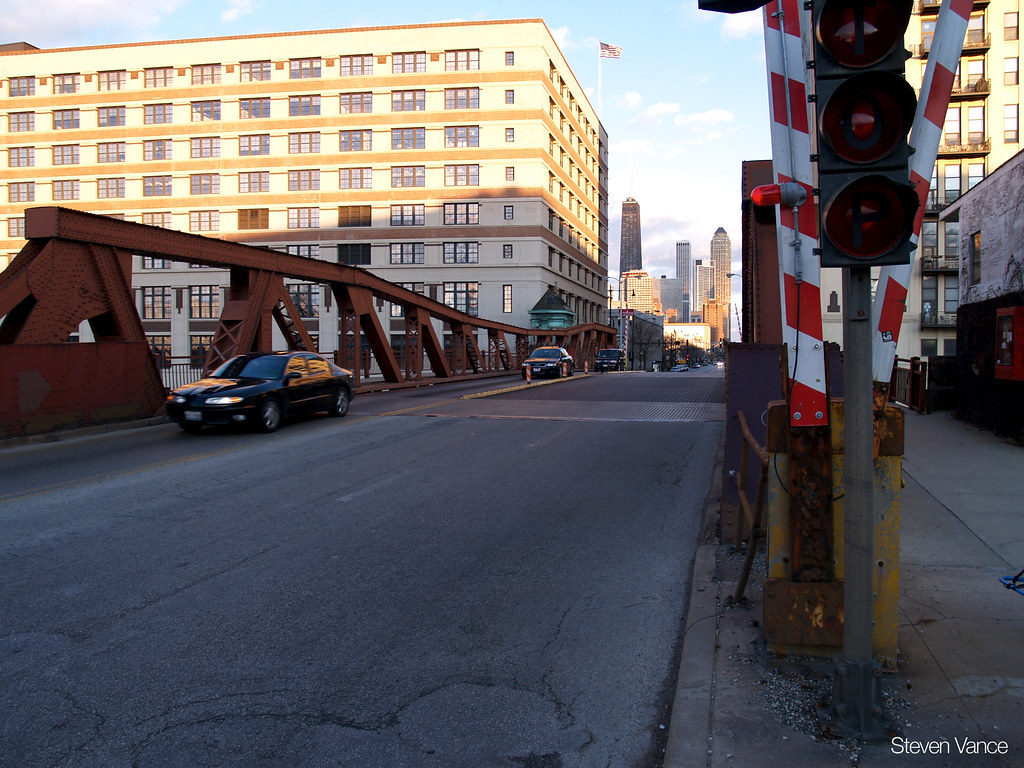
Looking west along the old Chicago Avenue Bridge. The pony (steel) truss bridge allows for road and river traffic over and through the truss, but with no cross brace across the top connecting its two sides. PHOTO: “Looking west on Chicago Avenue bridge” by Steven Vance is licensed under CC BY-NC-SA 2.0
The open-grate roadway and pony truss bascule design were characteristic solutions for heavily trafficked urban waterways. The bridge served as a critical link between the Near North Side and the Near West Side for more than a century.
A pony truss bridge is a steel truss bridge that allows traffic over and through the truss, but with no cross brace across the top connecting its two sides. The truss bridge assembly of the Chicago Avenue Bridge was made of riveted steel beams—and a witness to Chicago’s early 20th century industrial manufacturing might.
As well as being “Hog Butcher For The World, Tool Maker, Stacker of Wheat, Player with Railroads and the Nation’s Freight Handler” as Carl Sandberg wrote in his 1914 poem, Chicago, published in the new (1912) Poetry magazine, Chicago was also at that time a world leader in steel production and bridge design.

Looking east at the new Chicago Avenue Bridge in November 1914. Public Domain.
The basic design of any bascule bridge is similar to a medieval castle drawbridge. A leaf or span rises and descends that permits traffic upon it and— for the Chicago Avenue Bridge— also traffic below it on the Chicago River.
Chicago boasts more than 50 movable bridges. Single-leaf (truss) bascule bridges were constructed where the river was not very wide and a single bridge deck goes up and down between abutments. This was often used for train traffic which was convenient since Chicago was and still remains the railroad capital of the United States.
The more common double-leaf (truss) bascule bridge— including the Chicago Avenue Bridge—consists of two leaves or spans which meet in the middle over the river. Counterweights on each side of the bridge beneath it in a river pit (or pits) balances, stabilizes and fortifies the vertical movement of the bridge deck.
If the bridge deck is single leaf, the “Chicago Style” bridge rises in a piece vertically to one side of the river. If the bridge deck is two leaves, each rise to their side of the river and descend to close again by meeting in the middle of the bridge deck.
Its steel construction and mechanical movable span illustrated Chicago’s emergence as a world leader in infrastructure and civil engineering. The structure was closely tied to the industrial, commercial, and maritime history of the Chicago River.

Structural View of a bascule leaf, Chicago Avenue Bridge. https://tile.loc.gov/storage-services/service/pnp/habshaer/il/il0800/il0823/photos/318219pr.jpg . Fair Use.
Bascule bridges are the most commonly found moveable bridges in the world because they operate quickly and efficiently. The Chicago Avenue Bridge was operated from a companion pitched-roof bridge house with rounded corners and rows of windows clad in decorative (today oxidized green) copper. The foundational portions of the bridge house were constructed of concrete. Upper portions were made of wood with roofing of vitrified tile. So far, the bridge house portion of the structure has not been demolished.
In 1914, the new Chicago Avenue Bridge across a jag of Chicago River abutting the national headquarters of Montgomery Ward whose complex was first built in 1907, made for a sleek, powerful, modern and elegant statement about industry and urban commerce in early 20th century Middle America.

The pitched-roof bridge house of the Chicago Avenue Bridge had rounded corners and rows of windows clad in decorative copper. PHOTO: “Offering a historic bridge for sale is a meaningless and empty gesture. RIP Chicago Avenue bridge.” by reallyboring is licensed under CC BY-NC-ND 2.0
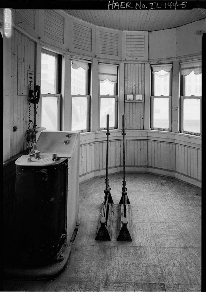
Interior of the concrete bridge house, 1914. Chicago Avenue Bridge. This was one of the first permanent and decorative bridge houses constructed for Chicago. see – https://www.loc.gov/pictures/item/il0823.photos.318222p/resource/ Public Domain.
Historic photographs of the bridge provide a record of a Chicago that was simultaneously industrial, architectural, and intensely urban.

When the Chicago Avenue Bridge opened in 1914, Chicago was the world leader in steel production and bridge design. Chicago Mayor Carter H. Harrison, Jr. (1860-1953) whose name appears on the dedication plaque was a five-term Democrat incumbent from 1897 to 1905 and from 1911 to 1915. PHOTO: “Carter H Harrison Mayor marker – Chicago Avenue Bridge” by swanksalot is licensed under CC BY-NC-SA 2.0
There are numerous variations and designs of the bascule bridge which in Chicago includes the trunnion (“pivot point”) bascule (“seesaw”) bridge. The nation’s first such bridge started operation in Chicago in 1902 over the north branch of the Chicago River at Cortland Street which can still be seen in operation today. The bridge design became known as the “Chicago Style” as its leaf or leaves, suspended on axles (trunnions) with massive concrete counterweights located below the bridge in the riverbank pit, opens and lifts a single or dual bridge deck to clear the river for traffic without blocking the waterway with a central pier.

Counterweight trunnion rack and pinion and counterweight, Chicago Avenue Bridge. see – https://www.loc.gov/pictures/item/il0823.photos.318218p/resource/ Public Domain.
Chicago’s bascule bridges—and the Chicago Avenue Bridge was one of them—were designed to its specific location. Each was designed to take on heavy loads and the attendant vibration which included the ice and snow pack of Chicago’s typically harsh winters. The design and construction into bedrock took into account wind resistance, whether the bridge leaves were open or closed, and to wind speeds of 100 miles per hour in any and all directions.
By 1920, improvements in bascule bridge design allowed for the construction of a double deck trunnion bascule bridge where car, truck and foot traffic could be carried simultaneously on its upper and lower decks. The first such double deck trunnion bascule bridge in Chicago was near the site of the old Fort Dearborn on the Chicago River at Michigan Avenue—today’s busy DuSable Bridge, formerly Michigan Avenue Bridge which opened in May 1920.
The Chicago Avenue Bridge is also significant as it belonged to a set of Chicago city bridges built between 1910 and 1915 whose designs looked to go beyond their utilitarian function to incorporate artistic and other aesthetic elements. Beginning with the Chicago Avenue Bridge in 1913, the Chicago Planning Commission worked with the city’s Bridge Division at the bascule bridge’s design stage.

Engineer’s blueprint of the Chicago Avenue Bridge, 1914. Public Domain. The blueprint shows the technical plans and cross-sections for the historical bascule drawbridge over the Chicago River at West Chicago Avenue. The detailed architectural drawings outline:
- The Top-Down Site Plan (Top): Shows the layout of the river channel, streetcar rails, sidewalks, and neighboring historic properties (like the Montgomery Ward Co. Building, Merchants Lighterage Co., and City Yards).
- The Structural Cross-Section (Middle): Details the bridge’s lane width, clearance dimensions, trolley wires, and structural framing.
- The Profile Elevation (Bottom): Illustrates the trunnion mechanics, bridge towers, operators’ houses, underwater riverbed depth, and the underground utility tunnels beneath the city datum line.
Demolition in 2018 reflected the ongoing tension between infrastructure modernization and historic preservation.
Following the demolition of the Chicago Avenue Bridge in 2018, an immoveable temporary steel girder bridge was installed in 2019 over this span of the Chicago River. For the moment, bridge design has returned to utilitarian functionality alone with little or no artistic or aesthetic program which had been one of the progressive features of the Chicago Avenue Bridge over a century ago.

Temporary replacement bridge, Chicago Avenue at the Chicago River, 2019. PHOTO: “Chicago – Chicago Avenue bridge, north branch of Chicago river” by ukdamian is licensed under CC BY-NC 2.0
SOURCES:
Blasius, Elizabeth. “Chicago Offers Up Historic Chicago Avenue Bridge for Free.” The Architect’s Newspaper, June 25, 2018. https://www.archpaper.com/2018/06/chicago-offers-historic-chicago-avenue-bridge-free/.
“Construction Near Chicago Avenue Bridge to Impact Traffic.” Curbed Chicago, October 29, 2018. https://chicago.curbed.com/2018/10/29/18038134/construction-chicago-avenue-bridge-traffic.
Holth, Nathan. “Chicago Avenue Bridge.” HistoricBridges.org. https://historicbridges.org/bridges/browser/?bridgebrowser=illinois/chicago/.
Library of Congress. “Chicago Avenue Bascule Bridge, Spanning North Branch of Chicago River at Chicago Avenue, Chicago, Cook County, IL.” Historic American Engineering Record, HAER IL-23. https://loc.gov/pictures/item/IL0823/.
Phillips, James S. “The Chicago Type Trunnion Bascule Bridge.” Chicago Loop Bridges. http://chicagoloopbridges.com/Ctype.html.
Preservation Chicago. “THREATENED: Historic Chicago Avenue Bridge Targeted for Demolition.” June 30, 2018. https://preservationchicago.org/newsletter_posts/threatened-historic-chicago-avenue-bridge-targeted-for-demolition/.
Solzman, David M. The Chicago River: An Illustrated History and Guide to the River and Its Waterways. Chicago: Wild Onion Books, 1998.